SUBCHAPTER 07H ‑ STATE GUIDELINES FOR AREAS OF ENVIRONMENTAL CONCERN
SECTION .0100 ‑ INTRODUCTION AND GENERAL COMMENTS
15A NCAC 07H .0101 INTRODUCTION
15A NCAC 07H .0102 CAMA PROVISIONS FOR AECS
15A NCAC 07H .0103 SELECTION OF PROPOSED AREAS FOR AEC DESIGNATION
History Note: Authority G.S. 113A‑101; 113A‑102; 113A‑102(a); 113A‑106; 113A‑107; 113A‑113(a); 113A‑118; 113A‑124; 113A‑124(c)(5);
Eff. September 9, 1977;
Amended Eff. December 1, 1985;
Expired Eff. April 1, 2018 pursuant to G.S. 150B-21.3A.
15a ncac 07h .0104 APPLICATION OF EROSION RATE SETBACK FACTORS
History Note: Authority G.S. 113A-107; 113A-113; 113A-124;
Eff. September 15, 1979;
Amended Eff. August 1, 2010; April 1, 2004; April 1, 1997; April 1, 1995; May 1, 1990; November 1, 1988; September 1, 1988;
Readopted Eff. July 1, 2020;
Repealed Eff. August 1, 2022.
15A NCAC 07H .0105 EFFECTIVE DATE OF RULE AMENDMENTS
Unless explicitly stated otherwise, the Coastal Resources Commission guidelines for Areas of Environmental Concern and local land use plans in effect at the time of permit decision shall be applied to all development proposals covered by this Subchapter.
History Note: Authority G.S. 113A‑107; 113A‑124;
Eff. December 1, 1982;
Readopted Eff. July 1, 2020.
15A NCAC 07H .0106 GENERAL DEFINITIONS
The following definitions apply whenever these terms are used in this Chapter:
(1) "Normal High Water" is the ordinary extent of high tide based on site conditions such as presence and location of vegetation which has its distribution influenced by tidal action, and the location of the apparent high tide line.
(2) "Normal Water Level" is the level of water bodies with less than six inches of lunar tide during periods of little or no wind. It can be determined by the presence of such physical and biological indicators as erosion escarpments, trash lines, water lines, marsh grasses, and barnacles.
(3) Unless specifically limited, the term "structures" includes, but is not limited to, buildings, bridges, roads, piers wharves and docks (supported on piles), bulkheads, breakwaters, jetties, mooring pilings and buoys, pile clusters (dolphins), navigational aids, and elevated boat ramps.
(4) "Mining" is defined as:
(a) the breaking of the surface soil in order to facilitate or accomplish the extraction or removal of mineral, ores, or other solid matter;
(b) any activity or process constituting all or part of a process for the extraction or removal of minerals, ores, soils, and other solid matter from their original Location; or
(c) the preparation, washing, cleaning, or other treatment of minerals, ores, or other solid matter so as to make them suitable for commercial, industrial, or construction use.
This definition applies regardless of whether the mining activity is for a commercial or noncommercial purpose, and regardless of the size of the affected area. Activities such as vibracoring, box coring, surface grab sampling, and other drilling and sampling for geotechnical testing, mineral resource investigations, or geological research are not considered mining. Excavation of mineral resources associated with the construction or maintenance of an approved navigation project in accordance with 15A NCAC 7B .0200 of this Chapter is not considered mining.
(5) "Wind Energy Facility" means the turbines, accessory buildings, transmission facilities, and any other equipment necessary for the operation of the facility that cumulatively, with any other wind energy facility whose turbines are located within one-half mile of one another, have a rated capacity of three megawatts or more of energy.
History Note: Authority G.S. 113A-102; 113A-107;
Eff. June 1, 1995;
Amended Eff. February 1, 2011; August 1, 1998; October 1, 1996;
Readopted Eff. July 1, 2020.
SECTION .0200 – THE ESTUARINE AND OCEAN SYSTEMS
15A nCAC 07H .0201 ESTUARINE AND OCEAN SYSTEM CATEGORIES
Included within the estuarine and ocean system are the following AEC categories:
(a) estuarine waters;
(b) coastal wetlands;
(c) public trust areas; and
(d) estuarine and public trust shorelines.
Each of the AECs is either geographically within the estuary or, because of its location and nature, may affect the estuarine and ocean system.
History Note: Authority G.S. 113A‑113(b)(1); 113A‑113(b)(2); 113A‑113(b)(5); 113A‑113(b)(6)b; 113A‑124;
Eff. September 9, 1977;
Amended Eff August 1, 2000; August 1, 1998;
Readopted Eff. July 1, 2020.
15A NCAC 07H .0202 SIGNIFICANCE OF THE SYSTEMS APPROACH IN ESTUARIES
History Note: Authority G.S. 113A‑107(a); 113A‑107(b); 113A‑124;
Eff. September 9, 1977;
Amended Eff. August 1, 1998;
Expired Eff. April 1, 2018 pursuant to G.S. 150B-21.3A.
15A NCAC 07H .0203 MANAGEMENT OBJECTIVE OF THE ESTUARINE AND OCEAN SYSTEM
It is the objective of the Coastal Resources Commission to conserve and manage estuarine waters, coastal wetlands, public trust areas, and estuarine and public trust shorelines, as an interrelated group of AECs, so as to safeguard and perpetuate their biological, social, economic, and aesthetic values and to ensure that development occurring within these AECs is compatible with natural characteristics so as to minimize the likelihood of significant loss of private property and public resources. Furthermore, it is the objective of the Coastal Resources Commission to protect present common‑law and statutory public rights of access to the lands and waters of the coastal area.
History Note: Authority G.S. 113A‑102(b)(1); 113A‑102(b)(4); 113A‑107(a); 113A‑107(b); 113A‑124;
Eff. September 9, 1977;
Amended Eff. August 1, 2000; October 1, 1993; September 1, 1985;
Readopted Eff. July 1, 2020.
15A NCAC 07H .0204 AECS WITHIN THE ESTUARINE AND OCEAN SYSTEM
History Note: Authority G.S. 113A‑107(a); 113A‑107(b); 113A‑124;
Eff. September 9, 1977;
Amended Eff. August 1, 1998;
Expired Eff. April 1, 2018 pursuant to G.S. 150B-21.3A.
15A NCAC 07H .0205 COASTAL WETLANDS
(a) Definition. "Coastal Wetlands" are defined as any salt marsh or other marsh subject to regular or occasional flooding by tides, including wind tides, that reach the marshland areas through natural or artificial watercourses, provided this does not include hurricane or tropical storm tides. Regular or occasional flooding shall be established through field indicators, including the observation of tidal water on the site, changes in elevation, presence of periwinkle (littoraria spp.), presence of crab burrows, staining, or wrack lines. Coastal wetlands may contain one or more of the following marsh plant species:
(1) Cord Grass (Spartina alterniflora);
(2) Black Needlerush (Juncus roemerianus);
(3) Glasswort (Salicornia spp.);
(4) Salt Grass (Distichlis spicata);
(5) Sea Lavender (Limonium spp.);
(6) Bulrush (Scirpus spp.);
(7) Saw Grass (Cladium jamaicense);
(8) Cat‑tail (Typha spp.);
(9) Salt Meadow Grass (Spartina patens);or
(10) Salt Reed Grass (Spartina cynosuroides).
The coastal wetlands AEC includes any contiguous lands designated by the Secretary of DEQ pursuant to G.S. 113-230(a).
(b) Significance. The unique productivity of the estuarine and ocean system is supported by detritus (decayed plant material) and nutrients that are exported from the coastal wetlands. Without the wetlands, the high productivity levels and complex food chains typically found in the estuaries could not be maintained. Additionally, coastal wetlands serve as barriers against flood damage and control erosion between the estuary and the uplands.
(c) Management Objective. It is the objective of the Coastal Resources Commission to conserve and manage coastal wetlands so as to safeguard and perpetuate their biological, social, economic and aesthetic values, and to coordinate and establish a management system capable of conserving and utilizing coastal wetlands as a natural resource necessary to the functioning of the entire estuarine system.
(d) Use Standards. Suitable land uses are those consistent with the management objective in this Rule. First priority of use shall be allocated to the conservation of existing coastal wetlands. Secondary priority of coastal wetland use shall be given to those types of development activities that require water access and cannot function elsewhere.
Unacceptable land uses include restaurants, businesses, residences, apartments, motels, hotels, trailer parks, parking lots, private roads, highways, and factories. Acceptable land uses include utility easements, fishing piers, docks, wildlife habitat management activities, and agricultural uses such as farming and forestry drainage as permitted under North Carolina's Dredge and Fill Law, G.S. 113-229, or applicable local, state, and federal laws.
In every instance, the particular location, use, and design characteristics shall be in accord with the general use standards for coastal wetlands, estuarine waters, and public trust areas described in Rule .0208 of this Section.
(e) Alteration of Coastal Wetlands. Alteration of coastal wetlands includes mowing or cutting of coastal wetlands vegetation whether by mechanized equipment or manual means. Alteration of coastal wetlands by federal or state resource management agencies as a part of planned resource management activities is exempt from the requirements of this Paragraph. Alteration of coastal wetlands shall be governed according to the following provisions:
(1) Alteration of coastal wetlands shall be exempt from the permit requirements of the Coastal Area Management Act (CAMA) when conducted in accordance with the following criteria:
(A) Coastal wetlands may be mowed or cut to a height of no less than two feet, as measured from the coastal wetland substrate, at any time and at any frequency throughout the year;
(B) Coastal wetlands may be mowed or cut to a height of no less than six inches, as measured from the coastal wetland substrate, once between each December 1 and March 31;
(C) Alteration of the substrate is not allowed;
(D) All cuttings or clippings shall remain in place as they fall;
(E) Coastal wetlands may be mowed or cut to a height of no less than six inches, as measured from the coastal wetland substrate, to create an access path four feet wide or less on waterfront lots without a pier access; and
(F) Coastal wetlands may be mowed or cut by utility companies as necessary to maintain utility easements.
(2) Coastal wetland alteration not meeting the exemption criteria of this Rule shall require a CAMA permit. CAMA permit applications for coastal wetland alterations are subject to review by the North Carolina Wildlife Commission, North Carolina Division of Marine Fisheries, U.S. Fish and Wildlife Service, and National Marine Fisheries Service in order to determine whether or not the proposed activity will have a significant adverse impact on the habitat or fisheries resources.
History Note: Authority G.S. 113A-107; 113A‑113(b)(1); 113A‑124;
Eff. September 9, 1977;
Amended Eff. September 1, 2016; November 1, 2009; August 1, 1998; October 1, 1993; May 1, 1990; January 24, 1978;
Readopted Eff. July 1, 2020.
15A NCAC 07H .0206 ESTUARINE WATERS
(a) Definition. "Estuarine Waters" are defined in G.S. 113A-113(b)(2) to include all the waters of the Atlantic Ocean within the boundary of North Carolina and all the waters of the bays, sounds, rivers and tributaries thereto seaward of the dividing line between coastal fishing waters and inland fishing waters. The boundaries between inland and coastal fishing waters are set forth in an agreement adopted by the Wildlife Resources Commission and the Department of Environment and Natural Resources and in the most current revision of the North Carolina Marine Fisheries Regulations for Coastal Waters, codified at 15A NCAC 3Q .0200.
(b) Significance. Estuarine waters are the dominant component and bonding element of the entire estuarine and ocean system, integrating aquatic influences from both the land and the sea. Estuaries are among the most productive natural environments of North Carolina. They support the valuable commercial and sports fisheries of the coastal area which are comprised of estuarine dependent species such as menhaden, flounder, shrimp, crabs, and oysters. These species must spend all or some part of their life cycle within the estuarine waters to mature and reproduce. Of the 10 leading species in the commercial catch, all but one are dependent on the estuary.
This high productivity associated with the estuary results from its unique circulation patterns caused by tidal energy, fresh water flow, and shallow depth; nutrient trapping mechanisms; and protection to the many organisms. The circulation of estuarine waters transports nutrients, propels plankton, spreads seed stages of fish and shellfish, flushes wastes from animal and plant life, cleanses the system of pollutants, controls salinity, shifts sediments, and mixes the water to create a multitude of habitats. Some important features of the estuary include mud and sand flats, eel grass beds, salt marshes, submerged vegetation flats, clam and oyster beds, and important nursery areas.
Secondary benefits include the stimulation of the coastal economy from the spin off operations required to service commercial and sports fisheries, waterfowl hunting, marinas, boatyards, repairs and supplies, processing operations, and tourist related industries. In addition, there is considerable nonmonetary value associated with aesthetics, recreation, and education.
(c) Management Objective. To conserve and manage the important features of estuarine waters so as to safeguard and perpetuate their biological, social, aesthetic, and economic values; to coordinate and establish a management system capable of conserving and utilizing estuarine waters so as to maximize their benefits to man and the estuarine and ocean system.
(d) Use Standards. Suitable land and water uses shall be those consistent with the management objectives in this Rule. Highest priority of use shall be allocated to the conservation of estuarine waters and their vital components. Second priority of estuarine waters use shall be given to those types of development activities that require water access and use which cannot function elsewhere such as simple access channels; structures to prevent erosion; navigation channels; boat docks, marinas, piers, wharfs, and mooring pilings.
In every instance, the particular location, use, and design characteristics shall be in accord with the general use standards for coastal wetlands, estuarine waters, and public trust areas described in Rule .0208 of this Section.
History Note: Authority G.S. 113A‑107(a); 113A‑107(b); 113A‑113(b)(2); 113A‑124;
Eff. September 9, 1977;
Amended Eff. August 1, 1998; October 1, 1993; November 1, 1991; May 1, 1990; October 1, 1988;
Readopted Eff. July 1, 2020.
15A NCAC 07H .0207 PUBLIC TRUST AREAS
(a) Definition. "Public trust areas" are all waters of the Atlantic Ocean and the lands thereunder from the mean high water mark to the seaward limit of state jurisdiction; all natural bodies of water subject to measurable lunar tides and lands thereunder to the normal high water or normal water level; all navigable natural bodies of water and lands thereunder to the normal high water or normal water level as the case may be, except privately-owned lakes to which the public has no right of access; all water in artificially created bodies of water containing public fishing resources or other public resources which are accessible to the public by navigation from bodies of water in which the public has rights of navigation; and all waters in artificially created bodies of water in which the public has acquired rights by prescription, custom, usage, dedication, or any other means. In determining whether the public has acquired rights in artificially created bodies of water, the following factors shall be considered:
(1) the use of the body of water by the public;
(2) the length of time the public has used the area;
(3) the value of public resources in the body of water;
(4) whether the public resources in the body of water are mobile to the extent that they can move into natural bodies of water;
(5) whether the creation of the artificial body of water required permission from the state; and
(6) the value of the body of water to the public for navigation from one public area to another public area.
(b) Significance. The public has rights in these areas, including navigation and recreation. In addition, these areas support commercial and sports fisheries, have aesthetic value, and are important resources for economic development.
(c) Management Objective. To protect public rights for navigation and recreation and to conserve and manage the public trust areas so as to safeguard and perpetuate their biological, economic and aesthetic value.
(d) Use Standards. Acceptable uses shall be those consistent with the management objectives in Paragraph (c) of this Rule. In the absence of overriding public benefit, any use which jeopardizes the capability of the waters to be used by the public for navigation or other public trust rights which the public may be found to have in these areas shall not be allowed. The development of navigational channels or drainage ditches, the use of bulkheads to prevent erosion, and the building of piers, wharfs, or marinas are examples of uses that may be acceptable within public trust areas, provided that such uses shall not be detrimental to the public trust rights and the biological and physical functions of the estuary. Projects which would directly or indirectly block or impair existing navigation channels, increase shoreline erosion, deposit spoils below normal high water, cause adverse water circulation patterns, violate water quality standards, or cause degradation of shellfish waters are considered incompatible with the management policies of public trust areas. In every instance, the particular location, use, and design characteristics shall be in accord with the general use standards for coastal wetlands, estuarine waters, and public trust areas described in Rule .0208 of this Section.
History Note: Authority G.S. 113A‑107(a); 113A‑107(b); 113A‑113(b)(5); 113A‑124;
Eff. September 9, 1977;
Amended Eff. February 1, 2006; October 1, 1993;
Readopted Eff. July 1, 2020.
15A NCAC 07H .0208 USE STANDARDS
(a) General Use Standards
(1) Uses that are not water dependent shall not be permitted in coastal wetlands, estuarine waters, and public trust areas. Restaurants, residences, apartments, motels, hotels, trailer parks, private roads, factories, and parking lots are examples of uses that are not water dependent. Uses that are water dependent include: utility crossings, wind energy facilities, docks, wharves, boat ramps, dredging, bridges and bridge approaches, revetments, bulkheads, culverts, groins, navigational aids, mooring pilings, navigational channels, access channels and drainage ditches;
(2) Before being granted a permit, the CRC or local permitting authority shall find that the applicant has complied with the following standards:
(A) The location, design, and need for development, as well as the construction activities involved shall be consistent with the management objective of the Estuarine and Ocean System AEC in Rule .0203 of this Section and shall be sited and designed to avoid significant adverse impacts upon the productivity and biologic integrity of coastal wetlands, shellfish beds, submerged aquatic vegetation as defined by the Marine Fisheries Commission in 15A NCAC 03I .0101(4)(i), and spawning and nursery areas;
(B) Development shall comply with State and federal water and air quality rules, statutes, and regulations;
(C) Development shall not cause irreversible damage to documented archaeological or historic resources as identified by the N.C. Department of Natural and Cultural Resources;
(D) Development shall not increase siltation;
(E) Development shall not create stagnant water bodies;
(F) Development shall be timed to avoid significant adverse impacts on life cycles of estuarine and ocean resources; and
(G) Development shall not jeopardize the use of the waters for navigation or for other public trust rights in public trust areas including estuarine waters.
(3) When the proposed development is in conflict with the general or specific use standards set forth in this Rule, the CRC may approve the development if the applicant can demonstrate that the activity associated with the proposed project will have public benefits consistent with the findings and goals of the Coastal Area Management Act identified in G.S. 113A-102, that the public benefits outweigh the adverse effects of the project, that there is no alternate site available for the project, and that all means and measures to mitigate adverse impacts of the project have been incorporated into the project design and shall be implemented at the applicant's expense. Measures taken to mitigate or minimize adverse impacts shall include actions that:
(A) minimize or avoid adverse impacts by limiting the magnitude or degree of the action;
(B) restore the affected environment; or
(C) compensate for the adverse impacts by replacing or providing substitute resources.
(4) "Primary nursery areas" are defined as those areas in the estuarine and ocean system where initial post larval development of finfish and crustaceans takes place and populations are uniformly in their early juvenile stages. Primary nursery areas are designated and described by the N.C. Marine Fisheries Commission (MFC) at 15A NCAC 03R .0103 and by the N.C. Wildlife Resources Commission (WRC) at 15A NCAC 10C .0502;
(5) "Outstanding Resource Waters" (ORW) are defined as those estuarine waters and public trust areas classified by the N.C. Environmental Management Commission (EMC) as defined in 15A NCAC 02B .0225; and
(6) Beds of "submerged aquatic vegetation" are defined as those habitats in public trust and estuarine waters, that occur in both subtidal and intertidal zones and may occur in isolated patches or cover extensive areas, vegetated with one or more species of submergent vegetation as listed in 15A NCAC 03I .0101(4)(i). Any rules relating to beds of submerged aquatic vegetation shall not apply to non-development control activities authorized by the Aquatic Weed Control Act of 1991 (G.S. 113A-220 et seq.).
(7) "Adverse impact", "adverse impacts", "adverse effects", or similar formulations, are defined as an effect or impact that is opposed to the goals of the Coastal Area Management Act as found in G.S. 113A-102(b) and with the provisions of G.S. 113-229(e).
(8) "Significant" as used in this Section includes consideration of both context and intensity. Context means that the impact or effect shall be analyzed from several perspectives that include society as a whole (human, national), the affected subregion of the North Carolina coast, the local area and all directly and indirectly affected parties. Both short- and long-term effects are relevant. Intensity refers to the severity of impact or effect. The following shall be considered in evaluating intensity:
(A) both adverse impacts as defined in Subparagraph (a)(7) of this Rule and impacts that promote or enhance the goals of the Coastal Area Management Act set out at G.S. 113A-102(b);
(B) the degree to which the proposed action affects public health or safety;
(C) unique characteristics of the geographic area;
(D) the degree to which the possible effects on the environment are uncertain or involve unique or unknown risks;
(E) the degree to which the CRC's permit decisions may establish a precedent for future CRC permit decisions;
(F) the degree to which the CRC's permit decisions are related to other CRC permit decisions with individually insignificant but cumulatively significant impacts. Significance cannot be avoided by terming an action temporary or by breaking it down into smaller component parts; and
(G) the degree to which the CRC's permit decision may cause the loss or destruction of scientific, cultural, historical, and environmental resources as those terms are commonly defined and understood.
(b) Specific Use Standards
(1) Navigation channels, canals, and boat basins shall be aligned or located so as to avoid primary nursery areas, shellfish beds, beds of submerged aquatic vegetation as defined in 15A NCAC 07H .0208(a)(6), or areas of coastal wetlands except as otherwise allowed within this Subchapter. Navigation channels, canals and boat basins shall also comply with the following standards:
(A) Navigation channels and canals may not be allowed through regularly and irregularly flooded coastal wetlands if the loss of wetlands will have significant adverse impacts on fishery resources, water quality, or adjacent wetlands. Navigation channels and canals may be allowed if there is no alternative that would avoid the wetland losses;
(B) All dredged material shall be confined landward of regularly and irregularly flooded coastal wetlands and stabilized to prevent entry of sediments into the adjacent water bodies or coastal wetlands;
(C) Dredged material from maintenance of channels and canals through coastal wetlands shall be placed on non‑wetland areas, remnant spoil piles, or disposed of by a method having no wetland impacts. Under no circumstances shall dredged material be placed on regularly or irregularly flooded wetlands. New dredged material disposal areas shall not be located in the buffer area as outlined in 15A NCAC 07H .0209(d)(10);
(D) Widths of excavated canals and channels shall be the minimum required to meet the applicant's needs but not impair water circulation;
(E) Any canal or boat basin shall be excavated no deeper than the depth of the connecting waters;
(F) Construction of finger canal systems are not allowed. Canals shall be either straight or meandering with no right angle corners;
(G) Canals shall be designed so as not to create an erosion hazard to adjoining property. Design may include shoreline stabilization, vegetative stabilization, or setbacks based on soil characteristics; and
(H) Maintenance excavation in canals, channels, and boat basins within primary nursery areas and beds of submerged aquatic vegetation as defined in 15A NCAC 03I .0101(4)(i), by the Marine Fisheries Commission shall be avoided. However, when essential to maintain a traditional and established use, maintenance excavation shall be approved if the applicant meets all of the following criteria:
(i) There has been navigational use of the area;
(ii) There exists a previously permitted channel that was constructed or maintained under permits issued by the State or federal government. If a natural channel was in use, or if a human‑made channel was constructed before permitting was necessary, there shall be evidence that the channel was continuously used for a specific purpose;
(iii) Excavated material can be removed and placed in a disposal area in accordance with Part (b)(1)(B) and Part (b)(1)(C) of this Rule without impacting adjacent nursery areas and beds of submerged aquatic vegetation as defined in 15A NCAC 03I .0101(4)(i) by the Marine Fisheries Commission;
(iv) The original depth and width of a human‑made or natural channel shall not be increased to allow a new or expanded use of the channel; and
(v) Consistent with the provisions of G.S. 113-229.
(2) Hydraulic Dredging
(A) The terminal end of the dredge pipeline shall be positioned at a distance sufficient to preclude erosion of the containment dike and a maximum distance from spillways to allow settlement of suspended solids;
(B) Dredged material shall be either confined on high ground by retaining structures or deposited on beaches for purposes of renourishment if the material is suitable in accordance with 15A NCAC 07H .0208(b)(8) and 15A NCAC 07H .0312 except as provided in Part (G) of this Subparagraph;
(C) Confinement of excavated materials shall be landward of all coastal wetlands and shall employ soil stabilization measures to prevent entry of sediments into the adjacent water bodies or coastal wetlands;
(D) Effluent from diked areas receiving disposal from hydraulic dredging operations shall be contained by pipe, trough, or similar device to a point waterward of emergent vegetation or, where local conditions require, below normal low water or normal water level;
(E) When possible, effluent from diked disposal areas shall be returned to the area being dredged;
(F) A water control structure shall be installed at the intake end of the effluent pipe;
(G) Publicly funded projects shall be considered by review agencies on a case‑by‑case basis with respect to dredging methods and dredged material disposal in accordance with Subparagraph (a)(3) of this Rule; and
(H) Dredged material from closed shellfish waters and effluent from diked disposal areas used when dredging in closed shellfish waters shall be returned to the closed shellfish waters.
(3) Drainage Ditches
(A) Drainage ditches located through any coastal wetland shall not exceed six feet wide by four feet deep (from ground surface) unless the applicant shows that larger ditches are necessary;
(B) Dredged material derived from the construction or maintenance of drainage ditches through regularly flooded marsh shall be placed landward of these marsh areas in a manner that will ensure that entry of sediment into the water or marsh will not occur. Dredged material derived from the construction or maintenance of drainage ditches through irregularly flooded marshes shall be placed on non-wetlands wherever feasible. Non‑wetland areas include existing disposal sites;
(C) Excavation of new ditches through high ground shall take place landward of an earthen plug or other methods to minimize siltation to adjacent water bodies; and
(D) Drainage ditches shall not have a significant adverse impact on primary nursery areas, productive shellfish beds, submerged aquatic vegetation beds as defined by the Marine Fisheries Commission in 15A NCAC 03I .0101(4)(i) or other estuarine habitat. Drainage ditches shall be designed so as to minimize the effects of freshwater inflows, sediment, and the introduction of nutrients to receiving waters. Settling basins, water gates, and retention structures are examples of design alternatives that may be used to minimize sediment introduction.
(4) Nonagricultural Drainage
(A) Drainage ditches shall be designed so that restrictions in the volume or diversions of flow are minimized to both surface and ground water;
(B) Drainage ditches shall provide for the passage of migratory organisms by allowing free passage of water of sufficient depth required to allow passage of those migratory organisms; and
(C) Drainage ditches shall not create stagnant water pools or changes in the velocity of flow.
(5) Marinas. "Marinas" are defined as any publicly or privately owned dock, basin, or wet boat storage facility constructed to accommodate more than 10 boats and providing any of the following services: permanent or transient docking spaces, dry storage, fueling facilities, haulout facilities, and repair service. Excluded from this definition are boat ramp facilities allowing access only, temporary docking, and none of the preceding services. Expansion of existing facilities shall comply with the standards of this Subparagraph for all development other than maintenance and repair necessary to maintain previous service levels. Marinas shall comply with the following standards:
(A) Marinas shall be sited in non‑wetland areas or in deep water areas not requiring dredging, and shall not disturb shellfish resources, beds of submerged aquatic vegetation as defined in 15A NCAC 03I .0101(4)(i) by the Marine Fisheries Commission, or wetland habitats, except for dredging necessary for access to high‑ground sites. The following alternatives for siting marinas shall be allowed.
(i) an upland basin site requiring no alteration of wetland or estuarine habitat and providing flushing by tidal or wind generated water circulation or basin design characteristics;
(ii) an upland basin site requiring dredging for access when the necessary dredging and operation of the marina will not result in significant adverse impacts to existing fishery, shellfish, or wetland resources and the basin design shall provide flushing by tidal or wind generated water circulation;
(iii) an open water site located outside a primary nursery area which utilizes piers or docks rather than channels or canals to reach deeper water; and
(iv) an open water marina requiring excavation of no intertidal habitat, and no dredging greater than the depth of the connecting channel.
(B) Marinas that require dredging shall not be located in primary nursery areas nor in areas which require dredging through primary nursery areas for access. Maintenance dredging in primary nursery areas for existing marinas shall comply with the standards set out in Part (b)(1)(I) of this Rule;
(C) Marinas to be developed in waters subject to public trust rights, other than those created by dredging upland basins or canals for the purpose of providing docking for residential developments shall be allowed no more than 27 square feet of public trust areas for every one linear foot of shoreline adjacent to these public trust areas for construction of docks and mooring facilities. The 27 square feet allocation does not apply to fairway areas between parallel piers or any portion of the pier used only for access from land to the docking spaces;
(E) Marinas shall not be located without written consent from the leaseholders or owners of submerged lands that have been leased from the State or deeded by the State;
(F) Marina basins shall be designed to promote flushing through the following design criteria:
(i) the basin and channel depths shall gradually increase toward open water and shall never be deeper than the waters to which they connect; and
(ii) when possible, an opening shall be provided at opposite ends of the basin to establish flow‑through circulation;
(G) Marinas shall be designed so that the capability of the waters to be used for navigation or for other public trust rights in estuarine or public trust waters are not jeopardized while allowing the applicant access to deep waters;
(H) Marinas shall be located and constructed so as to avoid impacts on navigation throughout all federally maintained channels and their boundaries as designated by the US Army Corps of Engineers. This includes permanent or temporary mooring sites; speed or traffic reductions; or any other device, either physical or regulatory, that may cause a federally maintained channel to be restricted;
(I) Open water marinas shall not be enclosed within breakwaters that preclude circulation sufficient to maintain water quality as determined by the Division of Water Resources.
(J) Marina design shall comply with all applicable EMC requirements 15A NCAC 02B .0200 for management of stormwater runoff. Stormwater management systems shall not be located within the 30-foot buffer area outlined in 15A NCAC 07H .0209(d);
(K) Marinas shall post a notice prohibiting the discharge of any waste from boat toilets and listing the availability of local pump‑out services;
(L) Boat maintenance areas shall be designed so that all scraping, sandblasting, and painting will be done over dry land with collection and containment devices that prevent entry of waste materials into adjacent waters;
(M) All applications for marinas shall be reviewed by the Division of Coastal Management to consider the cumulative impacts of marina development in accordance with G.S. 113A-120(a)(10); and
(N) Replacement of existing marinas to maintain previous service levels shall be allowed provided that the development complies with the standards for marina development within this Section.
(6) Piers and Docking Facilities.
(A) Piers shall not exceed six feet in width. Piers greater than six feet in width shall be permitted only if the greater width is necessary for safe use, to improve public access or to support a water dependent use that cannot otherwise occur;
(B) The total square footage of docks, platforms, and mooring facilities (excluding the pier) allowed shall be eight square feet per linear foot of shoreline with a maximum of 2,000 square feet to limit shading impacts to the substrate. In calculating the total square footage, uncovered open water slips shall not be counted in the total. Projects requiring dimensions greater than those stated in this Rule shall be permitted only if the greater dimensions are necessary for safe use, to improve public access, or to support a water dependent use that cannot otherwise occur. Size restrictions shall not apply to marinas;
(C) Piers and docking facilities over coastal wetlands shall be no wider than six feet and shall be elevated at least three feet above any coastal wetland substrate as measured from the bottom of the decking;
(D) A boathouse shall not exceed 400 square feet except to accommodate a documented need, provided to the Division of Coastal Management by the applicant for a larger boathouse and shall have sides extending no farther than one-half the height of the walls as measured from the Normal Water Level or Normal High Water to the bottom edge of the roofline, and covering only the top half of the walls. Measurements of square footage shall be taken of the greatest exterior dimensions. Boathouses shall not be allowed on lots with less than 75 linear feet of shoreline, except that structural boat covers utilizing a frame-supported fabric covering may be permitted on properties with less than 75 linear feet of shoreline when using screened fabric for side walls. Size restrictions do not apply to marinas;
(E) The total area enclosed by an individual boat lift shall not exceed 400 square feet except to accommodate a documented need for a larger boat lift;
(F) Piers and docking facilities shall be single story. They may be roofed but shall not be designed to allow second story use;
(G) Pier and docking facility length shall be limited by:
(i) not extending into the channel portion of the water body; and
(ii) not extending more than one-fourth the width of a natural water body, or human-made canal or basin. Measurements to determine widths of the water body, canals, or basins shall be made from the waterward edge of any coastal wetland vegetation that borders the water body. The one-fourth length limitation does not apply in areas where the U.S. Army Corps of Engineers, or a local government in consultation with the Corps of Engineers, has established an official pier‑head line. The one-fourth length limitation shall not apply when the proposed pier is located between longer piers or docking facilities within 200 feet of the applicant's property.
(iii) Notwithstanding Subparts (i) and (ii) of this Part, the proposed pier or docking facility shall not be longer than the pier head line established by the piers or docking facilities along the same contiguous shoreline having the same land use, nor longer than one-third the width of the water body. This restriction does not apply to piers 100 feet or less in length unless necessary to avoid unreasonable interference with navigation or other uses of the waters by the public.
(H) Piers or docking facilities longer than 400 feet shall be permitted only if the proposed length gives access to deeper water at a rate of at least 1 foot for each 100 foot increment of length longer than 400 feet, or, if the additional length is necessary to span some obstruction to navigation. Measurements to determine lengths shall be made from the waterward edge of any coastal wetland vegetation that borders the water body;
(I) Piers and docking facilities shall not interfere with the access to any riparian property and shall have a minimum setback of 15 feet between any part of the pier or docking facility and the adjacent property owner's areas of riparian access. The line of division of areas of riparian access shall be established by drawing a line along the channel or deep water in front of the properties, then drawing a line perpendicular to the line of the channel so that it intersects with the shore at the point the upland property line meets the water's edge. The minimum setback provided in the rule may be waived by the written agreement of the adjacent riparian owner(s) or when two adjoining riparian owners are co‑applicants. If the adjacent property is sold before construction of the pier or docking facility commences, the applicant shall obtain a written agreement with the new owner waiving the minimum setback and submit it to the permitting agency prior to initiating any development of the pier. Application of this Rule may be aided by reference to the approved diagram in 15A NCAC 07H .1205(t) illustrating the rule as applied to various shoreline configurations. When shoreline configuration is such that a perpendicular alignment cannot be achieved, the pier shall be aligned to meet the intent of this Rule to the maximum extent practicable as determined by the Director of the Division of Coastal Management; and
(J) Applicants for authorization to construct a pier or docking facility shall provide notice of the permit application to the owner of any part of a shellfish franchise or lease over which the proposed dock or pier would extend. The applicant shall allow the lease holder the opportunity to mark a navigation route from the pier to the edge of the lease.
(7) Bulkheads
(A) Bulkhead alignment, for the purpose of shoreline stabilization, shall approximate the location of normal high water or normal water level;
(B) Bulkheads shall be constructed landward of coastal wetlands in order to avoid significant adverse impacts to coastal resources;
(C) Bulkhead backfill material shall be obtained from an upland source approved by the Division of Coastal Management pursuant to this Section, or if the bulkhead is a part of a permitted project involving excavation from a non‑upland source, the material so obtained may be contained behind the bulkhead;
(D) Bulkheads shall be permitted below normal high water or normal water level only when the following standards are met:
(i) the property to be bulkheaded has an identifiable erosion problem, whether it results from natural causes or adjacent bulkheads, or it has unusual geographic or geologic features, e.g. steep grade bank;
(ii) the bulkhead alignment extends no further below normal high water or normal water level than necessary to allow recovery of the area eroded in the year prior to the date of application, to align with adjacent bulkheads, or to mitigate the unusual geographic or geologic features;
(iii) the bulkhead alignment will not adversely impact public trust rights or the property of adjacent riparian owners; and
(iv) the property to be bulkheaded is in a non-oceanfront area.
(E) Where possible, sloping rip‑rap, gabions, or vegetation shall be used rather than bulkheads.
(8) Beach Nourishment
(A) Beach creation or maintenance shall be allowed to enhance water related recreational facilities for public, commercial, and private use if consistent with all of the following:
(i) Beaches are located in areas where they have historically been found due to natural processes;
(ii) Material placed in the water and along the shoreline shall be clean sand. Grain size shall be equal to that found naturally at the site;
(iii) Beach creation shall not be allowed in primary nursery areas, nor in any areas where siltation from the site would pose a threat to shellfish beds;
(iv) Material shall not be placed on any coastal wetlands or submerged aquatic vegetation beds as defined by the Marine Fisheries Commission in 15A NCAC 03I .0101(4)(i);
(v) Material shall not be placed on any submerged bottom with shellfish resources as identified by the Division of Marine Fisheries during the permit review; and
(vi) Beach construction shall not cause filling of adjacent navigation channels, canals, or boat basins.
(B) Placing unconfined sand material in the water and along the shoreline shall not be allowed as a method of shoreline erosion control;
(C) Material from dredging projects may be used for beach nourishment if:
(i) it is first handled in a manner consistent with dredged material disposal as set forth in 15A NCAC 07H .0208;
(ii) it is allowed to dry prior to being placed on the beach; and
(iii) only that material of acceptable grain size as set forth in Subpart (b)(8)(A)(ii) of this Rule is removed from the disposal site for placement on the beach. Material shall not be placed directly on the beach by dredge or dragline during maintenance excavation.
(D) The renewal of permits for beach nourishment projects shall require an evaluation by the Division of Coastal Management of any significant adverse impacts of the original work; and
(E) Permits issued for beach nourishment shall be limited to authorizing beach nourishment only one time.
(9) Groins
(A) Groins shall not extend more than 25 feet waterward of the normal high water or normal water level unless a longer structure is justified by site specific conditions and by an individual who meets any North Carolina occupational licensing requirements for the type of structure being proposed and approved during the application process;
(B) Groins shall be set back a minimum of 15 feet from the adjoining riparian lines. The setback for rock groins shall be measured from the toe of the structure. This setback may be waived by written agreement of the adjacent riparian owner(s) or when two adjoining riparian owners are co‑applicants. Should the adjacent property be sold before construction of the groin commences, the applicant shall obtain a written agreement with the new owner waiving the minimum setback and submit it to the permitting agency prior to initiating any development of the groin;
(C) Groins shall pose no threat to navigation;
(D) The height of groins shall not exceed one foot above normal high water or normal water level;
(E) No more than two structures shall be allowed per 100 feet of shoreline unless the applicant provides the Division of Coastal Management a design showing that more structures are needed for shoreline stabilization. The groin structures shall be designed by an individual who meets any North Carolina occupational licensing requirements for the structures being proposed.
(F) "L" and "T" sections shall not be allowed at the end of groins; and
(G) Riprap material used for groin construction shall be free from loose dirt and of a size sufficient to prevent its movement from the site by wave and current action.
(10) "Freestanding Moorings".
(A) A "freestanding mooring" is any means to attach a ship, boat, vessel, floating structure, or other water craft to a stationary underwater device, mooring buoy, buoyed anchor, or piling as long as the piling is not associated with an existing or proposed pier, dock, or boathouse;
(B) Freestanding moorings shall be permitted only:
(i) to riparian property owners within their riparian corridors;
(ii) to any applicant proposing to locate a mooring buoy consistent with a water use plan that is included in either the local zoning or land use plan; or
(iii) is associated with commercial shipping, public service, or temporary construction or salvage operations.
(C) All mooring fields shall provide an area for access to any moorings and other land based operations that shall include wastewater pumpout, trash disposal, and vehicle parking;
(D) To protect water quality of shellfishing areas, mooring fields shall not be located within areas where shellfish harvesting for human consumption is a significant existing use or adjacent to such areas if shellfish harvest closure will result from the location of the mooring field. In compliance with Section 101(a)(2) of the Federal Water Pollution Control Act, 33 U.S.C. 1251 (a)(2), and North Carolina Water Quality Standards adopted pursuant to that section, shellfish harvesting is a significant existing use if it can be established that shellfish have been regularly harvested for human consumption since November 28, 1975 or that shellfish are propagating and surviving in a biologically suitable habitat and are available and suitable for harvesting for the purpose of human consumption as determined by the Division of Marine Fisheries in accordance with 15A NCAC 18A .0900. The Division of Marine Fisheries shall be consulted regarding the significance of shellfish harvest as an existing use and the magnitude of the quantities of shellfish that have been harvested or are available for harvest in the area where harvest will be affected by the development;
(E) Moorings shall not be located without written consent from the leaseholders or owners of submerged lands that have been leased from the state or deeded by the State;
(F) Moorings shall be located and constructed so as to avoid impacts on navigation throughout all federally maintained channels. This includes permanent or temporary mooring sites, speed or traffic reductions, or any other device, either physical or regulatory, which may cause a federally maintained channel to be restricted;
(G) Open water moorings shall not be enclosed within breakwaters that preclude circulation and degrade water quality in violation of EMC in accordance with 15A NCAC 02B .0225.
(H) Mooring fields shall have posted in view of patrons a notice prohibiting the discharge of any waste from boat toilets or any other discharge and listing the availability of local pump-out services and waste disposal;
(I) Freestanding mooring buoys and piles shall be evaluated based upon the arc of the swing including the length of the vessel to be moored. Moorings and the attached vessel shall not interfere with the access of any riparian owner nor shall it block riparian access to channels or deep water, which allows riparian access. Freestanding moorings shall not interfere with the ability of any riparian owner to place a pier for access;
(J) Freestanding moorings shall not be established in submerged cable or pipe crossing areas or in a manner that interferes with the operations of an access through any bridge;
(K) Freestanding moorings shall be marked or colored in compliance with U.S. Coast Guard and the WRC requirements and the required marking maintained for the life of the mooring(s); and
(L) The type of material used to create a mooring must be of a design and type of material so as to not present a hazard to navigation or public safety.
(11) Filling of Canals, Basins and Ditches - Notwithstanding the general use standards for estuarine systems as set out in Paragraph (a) of this Rule, filling canals, basins and ditches shall be allowed if all of the following conditions are met:
(A) the area to be filled was not created by excavating lands which were below the normal high water or normal water level;
(B) if the area was created from wetlands, the elevation of the proposed filling does not exceed the elevation of said wetlands so that wetland function will be restored;
(C) the filling will not adversely impact any designated primary nursery area, shellfish bed, beds of submerged aquatic vegetation as defined by the Marine Fisheries Commission in 15A NCAC 03I .0101(4)(i), coastal wetlands, public trust right, or public trust usage; and
(D) the filling will not adversely affect the value and enjoyment of property of any riparian owner.
(12) "Submerged Lands Mining"
(A) Development Standards. Mining of submerged lands shall meet all the following standards:
(i) The Division of Coastal Management shall evaluate the biological productivity and biological significance of mine sites, or borrow sites used for sediment extraction for significant adverse impacts and a protection strategy for these sites provided with the State approval request or permit application;
(ii) Natural reefs, coral outcrops, artificial reefs, seaweed communities, and significant benthic communities identified by the Division of Marine Fisheries or the WRC shall be avoided;
(iii) Mining shall avoid archaeological resources and shipwrecks identified by the Department of Cultural Resources; and unique geological features that require protection from uncontrolled or incompatible development as identified by the Division of Energy, Mineral, and Land Resources pursuant to G.S. 113A-113(b)(4)(g);
(iv) Mining activities shall not be conducted on or within 500 meters of biological communities identified by the Division of Marine Fisheries or the WRC, such as high relief hard bottom areas. "High relief" is defined for this Part as relief greater than or equal to one-half meter per five meters of horizontal distance;
(v) Mining activities shall be timed to minimize impacts on the life cycles of estuarine or ocean resources; and
(vi) Mining activities shall not negatively affect potable groundwater supplies, wildlife, freshwater, estuarine, or marine fisheries.
(B) Permit Conditions. Permits for submerged lands mining shall be conditioned on the applicant amending the mining proposal to include measures necessary to ensure compliance with the provisions of the Mining Act and the rules for development set out in this Subchapter. Permit conditions shall also include:
(i) Monitoring by the applicant to ensure compliance with all applicable development standards; and
(ii) A determination of the necessity and feasibility of restoration shall be made by the Division of Coastal Management as part of the permit or consistency review process. Restoration shall be necessary where it will facilitate recovery of the pre-development ecosystem. Restoration shall be considered feasible unless, after consideration of all practicable restoration alternatives, the Division of Coastal Management determines that the adverse effects of restoration outweigh the benefits of the restoration on estuarine or ocean resources. If restoration is determined to be necessary and feasible, then the applicant shall submit a restoration plan to the Division of Coastal Management prior to the issuance of the permit.
(C) Dredging activities for the purposes of mining natural resources shall be consistent with the development standards set out in 15A NCAC 07H .0208.
(D) Mitigation. Where mining cannot be conducted consistent with the development standards set out in this Rule, the applicant may request mitigation approval under 15A NCAC 07M .0700; and
(13) "Wind Energy Facilities"
(A) An applicant for the development and operation of a wind energy facility shall provide:
(i) an evaluation of the proposed noise impacts of the turbines to be associated with the proposed facility;
(ii) an evaluation of shadow flicker impacts for the turbines to be associated with the proposed facility;
(iii) an evaluation of avian and bat impacts of the proposed facility;
(iv) an evaluation of viewshed impacts of the proposed facility;
(v) an evaluation of potential user conflicts associated with development in the proposed project area; and
(vi) a plan regarding the action to be taken upon decommissioning and removal of the wind energy facility. The plan shall include estimates of monetary costs, time frame of removal, and the proposed site condition after decommissioning.
(B) Development Standards. Development of wind energy facilities shall meet the following standards in addition to adhering to the requirements outlined in Part (a)(13)(A) of this Rule:
(i) Natural reefs, coral outcrops, artificial reefs, seaweed communities, and significant benthic communities identified by the Division of Marine Fisheries or the WRC shall be avoided;
(ii) Development shall not be sited on or within 500 meters of biological communities identified by the Division of Marine Fisheries or the WRC, such as high relief hard bottom areas. High relief is defined for this standard as relief greater than or equal to one-half meter per five meters of horizontal distance;
(iii) Development shall not cause irreversible damage to documented archeological resources including shipwrecks identified by the Department of Natural and Cultural Resources and unique geological features as identified by the State Archeologist pursuant to G.S. 113A-113(b)(4)(g) that require protection from uncontrolled or incompatible development;
(iv) Development activities shall be timed to avoid significant adverse impacts on the life cycles of estuarine or ocean resources, or wildlife;
(v) Development or operation of a wind energy facility shall not jeopardize the use of the surrounding waters for navigation or for other public trust rights in public trust areas or estuarine waters; and
(vi) Development or operation of a wind energy facility shall not interfere with air navigation routes, air traffic control areas, military training routes, or, special use airspace and shall comply with standards adopted by the Federal Aviation Administration and codified under 14 CFR Part 77.13.
(C) Permit Conditions. Permits for wind energy facilities may be conditioned on the applicant amending the proposal to include measures necessary to ensure compliance with the standards for development set out in this Rule. Permit conditions may include monitoring to ensure compliance with all applicable development standards.
History Note: Authority G.S. 113A‑107(b); 113A‑108; 113A‑113(b); 113A-115; 113A-115.1; 113A‑124; 113-229;
Eff. September 9, 1977;
Amended Eff. February 1, 1996; April 1, 1993; February 1, 1993; November 30, 1992;
RRC Objection due to ambiguity Eff. March 21, 1996;
Amended Eff. August 1, 2012(see S.L. 2012-143, s.1.(f)); February 1, 2011; August 1, 2010;
June 1, 2010; August 1, 1998; May 1, 1996;
Readopted Eff. July 1, 2020;
Amended Eff. June 17, 2024; August 1, 2022.
15A NCAC 07H .0209 COASTAL SHORELINES
(a) Description. The Coastal Shorelines category includes the estuarine shorelines and public trust shorelines Area of Environmental Concern (AEC).
(1) Estuarine shorelines AEC are those non-ocean shorelines extending from the normal high water level or normal water level along the estuarine waters, estuaries, sounds, bays, fresh and brackish waters, and public trust areas as set forth in an agreement adopted by the Wildlife Resources Commission and the Department of Environmental Quality described in 15A NCAC 03Q .0202 for a distance of 75 feet landward. For those estuarine shorelines immediately contiguous to waters classified as Outstanding Resource Waters (ORW) by the Environmental Management Commission (EMC), the estuarine shoreline AEC shall extend to 575 feet landward from the normal high water level or normal water level, unless the Coastal Resources Commission establishes the boundary at a greater or lesser extent following required public hearing(s) within the affected county or counties.
(2) Public trust shorelines AEC are those non-ocean shorelines immediately contiguous to public trust areas, as defined in Rule 07H .0207(a) of this Section, located inland of the dividing line between coastal fishing waters and inland fishing waters as set forth in that agreement and extending 30 feet landward of the normal high water level or normal water level.
(b) Significance. When the Commission or the Department evaluate a project in the Coastal Shoreline AECs, such as permitting, variance requests, or federal consistency reviews, they shall consider efforts to avoid and minimize the impacts to the following:
(1) The quality of estuarine and ocean life,
(2) Shore front erosion and flooding,
(3) The productivity of the natural environments, such as those which support commercial and sport fisheries, and
(4) Features that provide important habitat areas for fish and wildlife, such as wetlands, flood plains, bluff shorelines, mud and sand flats, and forested shorelines.
(c) Management Objectives. All shoreline development shall be compatible with the dynamic nature of coastal shorelines as well as the values and the management objectives of the estuarine and ocean system. Included in management objectives are the necessity to conserve and manage the important natural features of the estuarine and ocean system so as to safeguard and perpetuate their biological, social, aesthetic, and economic values; to coordinate and establish a management system capable of conserving and utilizing these shorelines so as to maximize their benefits to the estuarine and ocean system and the people of North Carolina.
(d) Use Standards. Acceptable uses shall be those consistent with the management objectives in Paragraph (c) of this Rule. These uses shall be limited to those types of development activities that will not be detrimental to the public trust rights and the biological and physical functions of the estuarine and ocean system. Every effort shall be made by the permit applicant to avoid or minimize adverse impacts of development to estuarine and coastal systems through the planning and design of the development project. To ensure a project avoids and minimizes adverse impacts, development shall comply with the following standards:
(1) All development projects, proposals, and designs shall preserve natural barriers to erosion, including peat marshland, resistant clay shorelines, and cypress-gum protective fringe areas adjacent to vulnerable shorelines.
(2) All development projects, proposals, and designs shall limit the construction of impervious surfaces and areas not allowing natural drainage to only so much as is necessary to service the primary purpose or use for which the lot is to be developed. Impervious surfaces shall not exceed 30 percent of the AEC area of the lot, unless the applicant can demonstrate, through innovative design, that the protection provided by the design would be equal to or exceed the protection by the 30 percent limitation. Redevelopment of areas exceeding the 30 percent impervious surface limitation shall be permitted if impervious areas are not increased and the applicant designs the project to comply with the rule to the maximum extent feasible.
(3) All development projects, proposals, and designs shall comply with the following mandatory standards of the North Carolina Sedimentation Pollution Control Act of 1973 pursuant to G.S. 113A-50 through 113A-67:
(A) All development projects, proposals, and designs shall provide for a buffer zone along the margin of the estuarine water that is sufficient to confine visible siltation within 25 percent of the buffer zone nearest the land disturbing development.
(B) No development project proposal or design shall propose an angle for graded slopes or fill that is greater than an angle that can be retained by vegetative cover or other erosion‑control devices or structures.
(C) All development projects, proposals, and designs that involve uncovering more than one acre of land shall plant a ground cover sufficient to restrain erosion within 30 working days of completion of the grading; unless the project involves clearing land for the purpose of forming a reservoir later to be inundated.
(4) Development shall not have a significant adverse impact on estuarine and ocean resources. Significant adverse impacts include development that would directly or indirectly impair water quality increase shoreline erosion, alter coastal wetlands or Submerged Aquatic Vegetation (SAV), deposit spoils waterward of normal water level or normal high water, or cause degradation of shellfish beds.
(5) Development shall not interfere with existing public rights of access to, or use of, navigable waters or public resources.
(6) No public facility shall be permitted if such a facility is likely to require public expenditures for maintenance and continued use, unless it can be shown that the public purpose served by the facility outweighs the required public expenditures for construction, maintenance, and continued use.
(7) Development shall not cause irreversible damage to valuable, historic architectural or archaeological resources as documented by the local historic commission or the North Carolina Department of Natural and Cultural Resources.
(8) Established common-law and statutory public rights of access to the public trust lands and waters in estuarine areas shall not be eliminated or restricted. Development shall not encroach upon public accessways nor shall it limit the use of the accessways.
(9) Within the AECs for shorelines contiguous to waters classified as ORW by the EMC, no CAMA permit shall be approved for any project that would be inconsistent with rules adopted by the CRC, EMC or MFC for estuarine waters, public trust areas, or coastal wetlands. For development activities not covered by specific use standards, no permit shall be issued if the activity would, based on site-specific information, degrade the water quality or outstanding resource values.
(10) Within the Coastal Shorelines category (estuarine and public trust shoreline AECs), new development shall be located a distance of 30 feet landward of the normal water level or normal high water level, with the exception of the following:
(A) Water-dependent uses as described in Rule 07H .0208(a)(1) of this Section;
(B) Pile-supported signs (in accordance with local regulations);
(C) Post- or pile-supported fences;
(D) Elevated, slatted, wooden boardwalks exclusively for pedestrian use and six feet in width or less. The boardwalk may be greater than six feet in width if it is to serve a public use or need;
(E) Crab Shedders, if uncovered with elevated trays and no associated impervious surfaces except those necessary to protect the pump;
(F) Decks/Observation Decks limited to slatted, wooden, elevated and unroofed decks that shall not singularly or collectively exceed 200 square feet;
(G) Grading, excavation and landscaping with no wetland fill except when required by a permitted shoreline stabilization project. Projects shall not increase stormwater runoff to adjacent estuarine and public trust waters;
(H) Development over existing impervious surfaces, provided that the existing impervious surface is not increased;
(I) Where application of the buffer requirement would preclude placement of a residential structure with a footprint of 1,200 square feet or less on lots, parcels and tracts platted prior to June 1, 1999, development shall be permitted within the buffer as required in Subparagraph (d)(10) of this Rule, providing the following criteria are met:
(i) Development shall minimize the impacts to the buffer and reduce runoff by limiting land disturbance to only so much as is necessary to construct and provide access to the residence and to allow installation or connection of utilities, such as water and sewer; and
(ii) The residential structure development shall be located a distance landward of the normal high water or normal water level equal to 20 percent of the greatest depth of the lot. Existing structures that encroach into the applicable buffer area may be replaced or repaired consistent with the criteria set out in 15A NCAC 07J .0210 and .0211; and
(J) Where application of the buffer requirement set out in Subparagraph (d)(10) of this Rule would preclude placement of a residential structure on an undeveloped lot platted prior to June 1, 1999 that are 5,000 square feet or less that does not require an on-site septic system, or on an undeveloped lot that is 7,500 square feet or less that requires an on-site septic system, development shall be permitted within the buffer if all the following criteria are met:
(i) The lot on which the proposed residential structure is to be located, is located between:
(I) Two existing waterfront residential structures, both of which are within 100 feet of the center of the lot and at least one of which encroaches into the buffer; or
(II) An existing waterfront residential structure that encroaches into the buffer and a road, canal, or other open body of water, both of which are within 100 feet of the center of the lot;
(ii) Development of the lot shall minimize the impacts to the buffer and reduce runoff by limiting land disturbance to only so much as is necessary to construct and provide access to the residence and to allow installation or connection of utilities;
(iii) Placement of the residential structure and pervious decking shall be aligned no further into the buffer than the existing residential structures and existing pervious decking on adjoining lots;
(iv) The first one and one-half inches of rainfall from all impervious surfaces on the lot shall be collected and contained on-site in accordance with the design standards for stormwater management for coastal counties as specified in 15A NCAC 02H .1005. The stormwater management system shall be designed by an individual who meets applicable State occupational licensing requirements for the type of system proposed and approved during the permit application process. If the residential structure encroaches into the buffer, then no other impervious surfaces shall be allowed within the buffer; and
(v) The lots shall not be adjacent to waters designated as approved or conditionally approved shellfish waters by the Shellfish Sanitation Section of the Division of Marine Fisheries of the Department of Environmental Quality.
(e) The buffer requirements in Paragraph (d) of this Rule shall not apply to Coastal Shorelines where the EMC has adopted rules that contain buffer standards.
(f) Specific Use Standards for ORW Coastal Shorelines.
(1) Within the AEC for estuarine and public trust shorelines contiguous to waters classified as ORW by the EMC, all development projects, proposals, and designs shall limit the built upon area in the AEC to no more than 25 percent or any lower site specific percentage as adopted by the EMC as necessary to protect the exceptional water quality and outstanding resource values of the ORW, and shall:
(A) provide a buffer zone of at least 30 feet from the normal high water line or normal water line; and
(B) otherwise be consistent with the use standards set out in Paragraph (d) of this Rule.
(2) Single-family residential lots that would not be buildable under the low-density standards defined in Subparagraph (f)(1) of this Rule may be developed for single-family residential purposes so long as the development complies with those standards to the maximum extent possible.
(g) Urban Waterfronts.
(1) Definition. Urban Waterfronts are waterfront areas, not adjacent to ORW, in the Coastal Shorelines category that lie within the corporate limits of any municipality duly chartered within the 20 coastal counties of the state. In determining whether an area is an urban waterfront, the following criteria shall be met:
(A) the area lies wholly within the corporate limits of a municipality; and
(B) the area has a central business district or similar commercial zoning classification where there are mixed land uses, and urban level services, such as water, sewer, streets, solid waste management, roads, police and fire protection, or in an area with an industrial or similar zoning classification adjacent to a central business district.
(2) Significance. When the Commission or the Department evaluate a project in Urban Waterfronts, such as permitting, variance requests, or federal consistency reviews, they shall consider efforts to avoid and minimize the impacts to the following:
(A) The cultural, historical, and economic significance of the area,
(B) Maritime traditions and longstanding development patterns,
(C) Planning and stormwater management, and
(D) The local aesthetics.
(3) Management Objectives. To provide for the continued cultural, historical, aesthetic and economic benefits of urban waterfronts. Activities such as in-fill development, reuse and redevelopment facilitate efficient use of already urbanized areas and reduce development pressure on surrounding areas, in an effort to minimize the adverse cumulative environmental effects on estuarine and ocean systems. While recognizing that opportunities to preserve buffers are limited in highly developed urban areas, they are encouraged where practical.
(4) Use Standards:
(A) The buffer requirement pursuant to Subparagraph (d)(10) of this Rule shall not apply to development within Urban Waterfronts that meets the following standards:
(i) The development shall be consistent with the locally adopted land use plan;
(ii) Impervious surfaces shall not exceed 30 percent of the AEC area of the lot. Impervious surfaces may exceed 30 percent if the applicant can demonstrate, through a stormwater management system design, that the protection provided by the design would be equal to or exceed the protection by the 30 percent limitation. The stormwater management system shall be designed by an individual who meets any North Carolina occupational licensing requirements for the type of system proposed and approved during the permit application process. Redevelopment of areas exceeding the 30 percent impervious surface limitation shall be permitted if impervious areas are not increased and the applicant designs the project to comply with the intent of the rule to the maximum extent feasible; and
(iii) The development shall meet all state stormwater management requirements as required by the EMC;
(B) Non-water dependent uses over estuarine waters, public trust waters and coastal wetlands shall be allowed only within Urban Waterfronts as set out below.
(i) Existing structures over coastal wetlands, estuarine waters or public trust areas may be used for commercial non-water dependent purposes. Commercial, non-water dependent uses shall be limited to restaurants and retail services. Residential uses, lodging and new parking areas shall be prohibited.
(ii) For the purposes of this Rule, existing enclosed structures may be replaced or expanded vertically provided that vertical expansion does not exceed the original footprint of the structure, is limited to one additional story over the life of the structure, and is consistent with local requirements or limitations.
(iii) New structures built for non-water dependent purposes are limited to pile-supported, single-story, unenclosed decks and boardwalks, and shall meet the following criteria:
(I) shall provide for enhanced public access to the shoreline;
(II) may be roofed but solid walls and permanent windows are prohibited. Non-permanent enclosures shall be limited to materials that are consistent with this Rule and shall be non-permanent and attached to the structure in a manner that allows removal;
(III) the decks and boardwalks shall not have permanent or attached heating or air conditioning;
(IV) shall require no filling of coastal wetlands, estuarine waters or public trust areas;
(V) shall not extend more than 20 feet waterward of the normal high water level or normal water level;
(VI) shall be elevated at least three feet over the wetland substrate as measured from the bottom of the decking;
(VII) shall have no more than six feet of any dimension extending over coastal wetlands;
(VIII) shall not interfere with access to any riparian property and shall have a minimum setback of 15 feet between any part of the structure and the adjacent property owners' areas of riparian access. The line of division of areas of riparian access shall be established by drawing a line along the channel or deep water in front of the properties, then drawing a line perpendicular to the line of the channel so that it intersects with the shore at the point the upland property line meets the water's edge. The minimum setback provided in the rule may be waived by the written agreement of the adjacent riparian owner(s) or when two adjoining riparian owners are co-applicants. Should the adjacent property be sold before construction of the structure commences, the applicant shall obtain a written agreement with the new owner waiving the minimum setback and submit it to the permitting agency prior to initiating any development;
(IX) shall be consistent with the US Army Corps of Engineers setbacks along federally authorized waterways;
(X) shall have no significant adverse impacts on fishery resources, water quality or adjacent wetlands and there shall be no alternative that would avoid wetlands. Significant adverse impacts include the development that would impair water quality standards, increase shoreline erosion, alter coastal wetlands or Submerged Aquatic Vegetation (SAV), deposit spoils waterward of normal water level or normal high water level, or cause degradation of shellfish beds;
(XI) shall not degrade waters classified as SA or High Quality Waters or ORW as defined by the EMC;
(XII) shall not degrade Critical Habitat Areas or Primary Nursery Areas as defined by the NC Marine Fisheries Commission; and
(XIII) shall not pose a threat to navigation.
History Note: Authority G.S. 113A-107(b); 113A-108; 113A-113(b); 113A-124;
Eff. September 1, 1977;
Amended Eff. April 1, 2001; August 1, 2000; August 3, 1992; December 1, 1991; May 1, 1990; October 1, 1989;
Temporary Amendment Eff. October 15, 2001 (exempt from 270 day requirement-S.L. 2000-142);
Temporary Amendment Eff. February 15, 2002 (exempt from 270 day requirement-S.L. 2001-494);
Amended Eff. April 1, 2019; March 1, 2010; April 1, 2008; August 1, 2002;
Readopted Eff. July 1, 2020;
Amended Eff. November 1, 2025.
SECTION .0300 ‑ OCEAN HAZARD AREAS
15A NCAC 07H .0301 OCEAN HAZARD CATEGORIES
The Ocean Hazard categories of AECs encompass the natural hazard areas along the Atlantic Ocean shoreline where, because of their vulnerability to erosion or other adverse effects of sand, wind, and water, uncontrolled or incompatible development could endanger life or property. Ocean hazard areas include beaches, frontal dunes, inlet lands, and other areas in which geologic, vegetative and soil conditions may subject the area to erosion or flood damage.
History Note: Authority G.S. 113A‑107(a); 113A‑107(b); 113A‑113(b)(6a); 113A‑113(b)(6b); 113A‑113(b)(6d); 113A‑124;
Eff. September 9, 1977;
Readopted Eff. December 1, 2020.
15A NCAC 07H .0302 SIGNIFICANCE OF THE OCEAN HAZARD CATEGORY
(a) Hazards associated with ocean shorelines are due to the constant forces exerted by waves, winds, and currents upon the unstable sands that form the shore. During storms, these forces are intensified and can cause changes in the bordering landforms and to structures located on them. Ocean hazard area property is in the ownership of a large number of private individuals as well as several public agencies and is used by a vast number of visitors to the coast. Ocean hazard areas are critical due to both the severity of the hazards and the intensity of interest in these areas.
(b) The location and form of the various hazard area landforms, in particular the beaches, dunes, and inlets, are in a permanent state of flux, responding to meteorologically induced changes in the wave climate. For this reason, the siting of development on and near these landforms shall be subject to the provisions in this Section in order to avoid their loss or damage. The flexible nature of these landforms presents hazards to development situated immediately on them and offers protection to the land, water, and structures located landward of them. The value of each landform lies in the particular role it plays in affording protection to life and property. Development shall not diminish the energy dissipation and sand storage capacities of the landforms essential to the maintenance of the landforms' protective function.
History Note: Authority G.S. 113A‑107(a); 113A‑107(b); 113A‑113(b)(6a); 113A‑113(b)(6b); 113A‑113(b)(6d); 113A‑124;
Eff. September 9, 1977;
Amended Eff. October 1, 1992;
Readopted Eff. December 1, 2020.
15A NCAC 07H .0303 MANAGEMENT OBJECTIVE OF OCEAN HAZARD AREAS
(a) The CRC recognizes that absolute safety from the destructive forces of the Atlantic Ocean shoreline is an impossibility for development located adjacent to the coast. The loss of life and property to these forces, however, can be greatly reduced by the proper location and design of structures and by care taken in prevention of damage to natural protective features particularly primary and frontal dunes. Therefore, it is the CRC's objective that development in ocean hazard areas shall be sited to minimize danger to life and property and achieve a balance between the financial, safety, and social factors that are involved in hazard area development.
(b) The rules set forth in this Section shall further the goals set out in G.S. 113A‑102(b), to minimize losses to life and property resulting from storms and long‑term erosion, prevent encroachment of permanent structures on public beach areas, preserve the natural ecological conditions of the barrier dune and beach systems, and reduce the public costs of development within ocean hazard areas, and protect common‑law and statutory public rights of access to and use of the lands and waters of the coastal area.
History Note: Authority G.S. 113A‑107(b); 113A‑113(b)(6) a.; 113A‑113(b)(6) b.;113A‑113(b)(6)d.; 113A‑124;
Eff. September 9, 1977;
Amended Eff. October 1, 1992; December 1, 1991; September 1, 1985; February 2, 1981;
Readopted Eff. December 1, 2020.
15A NCAC 07H .0304 AECS WITHIN OCEAN HAZARD AREAS
The ocean hazard AECs contain all of the following areas:
(1) Ocean Erodible Area. This is the area where there exists a substantial possibility of excessive erosion and significant shoreline fluctuation. The oceanward boundary of this area is the mean low water line. The landward extent of this area is the distance landward from the vegetation line as defined in 15A NCAC 07H .0305(a)(5) to the recession line established by multiplying the long‑term annual erosion rate times 90; provided that, where there has been no long‑term erosion or the rate is less than two feet per year, this distance shall be set at 180 feet landward from the vegetation line. For the purposes of this Rule, the erosion rates are the long-term average based on available historical data. The current long-term average erosion rate data for each segment of the North Carolina coast is depicted on maps entitled "North Carolina 2019 Oceanfront Setback Factors & Long-Term Average Annual Erosion Rate Update Study" and approved by the Coastal Resources Commission on February 28, 2019 (except as such rates may be varied in individual contested cases or in declaratory or interpretive rulings). In all cases, the rate of shoreline change shall be no less than two feet of erosion per year. The maps are available without cost from any Local Permit Officer or the Division of Coastal Management on the internet at http://www.nccoastalmanagement.net.
(2) Inlet Hazard Area. The inlet hazard areas are natural‑hazard areas that are especially vulnerable to erosion, flooding, and other adverse effects of sand, wind, and water because of their proximity to dynamic ocean inlets. This area extends landward from the mean low water line a distance encompassing that area within which the inlet migrates, based on statistical analysis, and shall consider such factors as previous inlet territory, structurally weak areas near the inlet, and external influences such as jetties, terminal groins, and channelization. The areas on the maps identified as Inlet Hazard Areas included in the report entitled INLET HAZARD AREAS, The Final Report and Recommendations to the Coastal Resources Commission, 1978, as amended in 1981, by Loie J. Priddy and Rick Carraway are incorporated by reference and are hereby designated as Inlet Hazard Areas, except for:
(a) the location of a former inlet which has been closed for at least 15 years;
(b) inlets that due to shoreline migration, no longer include the current location of the inlet; and
(c) inlets providing access to a State Port via a channel maintained by the United States Army Corps of Engineers.
In all cases, the Inlet Hazard Area shall be an extension of the adjacent ocean erodible areas and in no case shall the width of the inlet hazard area be less than the width of the adjacent ocean erodible area. This report is available for inspection at the Department of Environmental Quality, Division of Coastal Management, 400 Commerce Avenue, Morehead City, North Carolina or at the website referenced in Item (1) of this Rule.
(3) Unvegetated Beach Area. Beach areas within the Ocean Hazard Area where no stable and natural vegetation is present may be designated as Unvegetated Beach Areas on either a permanent or temporary basis as follows:
(a) An area appropriate for permanent designation as an Unvegetated Beach Area is a dynamic area that is subject to rapid unpredictable landform change due to wind and wave action. The areas in this category shall be designated following studies by the Division of Coastal Management. These areas shall be designated on maps approved by the Coastal Resources Commission and available without cost from any Local Permit Officer or the Division of Coastal Management on the internet at the website referenced in Item (1) of this Rule.
(b) An area that is unvegetated as a result of a hurricane or other major storm event may be designated by the Coastal Resources Commission as an Unvegetated Beach Area for a specific period of time, or until the vegetation has re-established in accordance with 15A NCAC 07H .0305(a)(5). At the expiration of the time specified or the re-establishment of the vegetation, the area shall return to its pre-storm designation.
(c) The Commission designates as temporary unvegetated beach areas those oceanfront areas of:
(i) Surf City and North Topsail Beach in which the vegetation line as shown on the United States National Oceanic and Atmospheric Administration imagery dated September 17, 2018 was destroyed as a result of Hurricane Florence in September 2018; and
(ii) Oak Island in which the vegetation line as shown on the United States National Oceanic and Atmospheric Administration and Geological Survey imagery dated August 4, 2020 was destroyed as a result of Hurricane Isaias in August 2020.
The designation AEC boundaries can be found on the Division's website at https://files.nc.gov/ncdeq/Coastal%20Management/GIS/unvegetated_beach_aec.pdf and https://files.nc.gov/ncdeq/Coastal%20Management/GIS/unveg_beachAEC_Oak_Island.zip. This designation shall continue until such time as the stable and natural vegetation has reestablished, or until the area is permanently designated as an unvegetated beach area pursuant to Sub-Item (3)(a) of this Rule.
(4) State Ports Inlet Management Area. These are areas adjacent to and within Beaufort Inlet and the mouth of the Cape Fear River, providing access to a State Port via a channel maintained by the Unites States Army Corps of Engineers. These areas are unique due to the influence of federally-maintained channels, and the critical nature of maintaining shipping access to North Carolina's State Ports. These areas may require specific management strategies not warranted at other inlets to address erosion and shoreline stabilization. State Ports Inlet Management Areas shall extend from the mean low water line landward as designated on maps approved by the Coastal Resources Commission and available without cost from the Division of Coastal Management, and on the internet at the website at https://files.nc.gov/ncdeq/Coastal%20Management/GIS/state_port_aec.pdf.
History Note: Authority G.S. 113A‑107; 113A-107.1; 113A‑113; 113A‑124;
Eff. September 9, 1977;
Amended Eff. December 1, 1993; November 1, 1988; September 1, 1986; December 1, 1985;
Temporary Amendment Eff. October 10, 1996;
Amended Eff. April 1, 1997;
Temporary Amendment Eff. October 10, 1996 Expired on July 29, 1997;
Temporary Amendment Eff. October 22, 1997;
Amended Eff. April 1, 2020; July 1, 2016; September 1, 2015; May 1, 2014; February 1, 2013; January 1, 2010; February 1, 2006; October 1, 2004; April 1, 2004; August 1, 1998;
Readopted Eff. December 1, 2020;
Amended Eff. August 1, 2022; September 1, 2021.
15A NCAC 07H .0305 DefINITION AND DESCRIPTION OF LANDFORMS
This Rule describes natural and man-made features that are found within the ocean hazard area of environmental concern.
(1) Ocean Beaches. Ocean beaches are lands consisting of unconsolidated soil materials that extend from the mean low water line landward to a point where either:
(a) the growth of vegetation occurs; or
(b) a distinct change in slope or elevation alters the configuration of the landform, whichever is farther landward.
(2) Nearshore. The nearshore is the portion of the beach seaward of mean low water that is characterized by dynamic changes both in space and time as a result of storms.
(3) Primary Dunes. Primary dunes are the first mounds of sand located landward of the ocean beaches having an elevation equal to the mean flood level (in a storm having a one percent chance of being equaled or exceeded in any given year) for the area plus six feet. Primary dunes extend landward to the lowest elevation in the depression behind that same mound of sand commonly referred to as the "dune trough".
(4) Frontal Dunes. The frontal dune is the first mound of sand located landward of ocean beaches that has stable and natural vegetation present.
(5) Vegetation Line. The vegetation line refers to the first line of stable and natural vegetation, which shall be used as the reference point for measuring oceanfront setbacks. This line represents the boundary between the normal dry‑sand beach, which is subject to constant flux due to waves, tides, storms and wind, and the more stable upland areas. The vegetation line is generally located at or immediately oceanward of the seaward toe of the frontal dune or erosion escarpment. The Division of Coastal Management or Local Permit Officer shall determine the location of the stable and natural vegetation line based on visual observations of plant composition and density. If the vegetation has been planted, it may be considered stable when the majority of the plant stems are from continuous rhizomes rather than planted individual rooted sets. Planted vegetation may be considered natural when the majority of the plants are mature and additional species native to the region have been recruited, providing stem and rhizome densities that are similar to adjacent areas that are naturally occurring. In areas where there is no stable and natural vegetation present, this line may be established by interpolation between the nearest adjacent stable natural vegetation by on-ground observations or by aerial photographic interpretation.
(6) Pre-project Vegetation Line. In areas within the boundaries of a large-scale beach fill project, the vegetation line that existed within one year prior to the onset of project construction shall be defined as the "pre-project vegetation line". The "onset of project construction" shall be defined as the date sediment placement begins, with the exception of projects completed prior to the original effective date of this Rule, in which case the award of the contract date will be considered the onset of construction. A pre-project vegetation line shall be established in coordination with the Division of Coastal Management using on-ground observation and survey or aerial imagery for all areas of oceanfront that undergo a large-scale beach fill project. Once a pre-project vegetation line is established, and after the onset of project construction, this line shall be used as the reference point for measuring oceanfront setbacks in all locations where it is landward of the vegetation line. In all locations where the vegetation line as defined in this Rule is landward of the pre-project vegetation line, the vegetation line shall be used as the reference point for measuring oceanfront setbacks. A pre-project vegetation line shall not be established where a pre-project vegetation line is already in place, including those established by the Division of Coastal Management prior to the effective date of this Rule. A record of all pre-project vegetation lines, including those established by the Division of Coastal Management prior to the effective date of this Rule, shall be maintained by the Division of Coastal Management for determining development standards as set forth in Rule .0306 of this Section. Because the impact of Hurricane Floyd in September 1999 caused significant portions of the vegetation line in the Town of Oak Island and the Town of Ocean Isle Beach to be relocated landward of its pre-storm position, the pre-project line for areas landward of the beach fill construction in the Town of Oak Island and the Town of Ocean Isle Beach, the onset of which occurred in 2000, shall be defined by the general trend of the vegetation line established by the Division of Coastal Management from June 1998 aerial orthophotography.
(7) Beach Fill. Beach fill refers to the placement of sediment along the oceanfront shoreline. Sediment used solely to establish or strengthen dunes shall not be considered a beach fill project under this Rule. A "large-scale beach fill project" shall be defined as any volume of sediment greater than 300,000 cubic yards or any storm protection project constructed by the U.S. Army Corps of Engineers.
(8) Erosion Escarpment. The normal vertical drop in the beach profile caused from high tide or storm tide erosion.
(9) Measurement Line. The line from which the ocean hazard setback as described in Rule .0306(a) of this Section is measured in the unvegetated beach area of environmental concern as described in Rule .0304(3) of this Section. In areas designated pursuant to Rule .0304(3)(b) of this Section, the Division of Coastal Management shall establish a measurement line by:
(a) determining the average distance the pre-storm vegetation line receded at the closest vegetated site adjacent to the area designated by the Commission as the unvegetated beach AEC; and
(b) mapping a line equal to the average recession determination in Part (a) of this Subparagraph, measured in a landward direction from the first line of stable and natural vegetation line on the most recent pre-storm aerial photography in the area designated as an unvegetated beach AEC.
History Note: Authority G.S. 113A‑107; 113A‑113(b)(6); 113A‑124;
Eff. September 9, 1977;
Amended Eff. December 1, 1992; September 1, 1986; December 1, 1985; February 2, 1981;
Temporary Amendment Eff. October 10, 1996;
Amended Eff. January 1, 1997;
Temporary Amendment Eff. October 10, 1996 Expired on July 29, 1997;
Temporary Amendment Eff. October 22, 1997;
Amended Eff. April 1, 2020; April 1, 2016; April 1, 2008; August 1, 2002; August 1, 1998;
Readopted Eff. December 1, 2020;
Amended Eff. August 1, 2022.
15A NCAC 07h .0306 GENERAL USE STANDARDS FOR OCEAN HAZARD AREAS
(a) In order to protect life and property, all development not otherwise specifically exempted or allowed by law or elsewhere in the Coastal Resources Commission's rules shall be located according to whichever of the following is applicable:
(1) The ocean hazard setback for development shall be measured in a landward direction from the vegetation line, the pre-project vegetation line, or the measurement line, whichever is applicable.
(2) The ocean hazard setback shall be determined by both the size of development and the shoreline long term erosion rate as defined in Rule .0304 of this Section. "Development size" is defined by total floor area for structures and buildings or total area of footprint for development other than structures and buildings. Total floor area includes the following:
(A) The total square footage of heated or air-conditioned living space;
(B) The total square footage of parking elevated above ground level; and
(C) The total square footage of non-heated or non-air-conditioned areas elevated above ground level, excluding attic space that is not designed to be load-bearing.
Decks, roof-covered porches, and walkways shall not be included in the total floor area unless they are enclosed with material other than screen mesh or are being converted into an enclosed space with material other than screen mesh.
(3) With the exception of those types of development defined in 15A NCAC 07H .0309(a), no development, including any portion of a building or structure, shall extend oceanward of the ocean hazard setback. This includes roof overhangs and elevated structural components that are cantilevered, knee braced, or otherwise extended beyond the support of pilings or footings. The ocean hazard setback shall be established based on the following criteria:
(A) A building or other structure less than 5,000 square feet requires a minimum setback of 60 feet or 30 times the shoreline erosion rate, whichever is greater;
(B) A building or other structure greater than or equal to 5,000 square feet but less than 10,000 square feet requires a minimum setback of 120 feet or 60 times the shoreline erosion rate, whichever is greater;
(C) A building or other structure greater than or equal to 10,000 square feet but less than 20,000 square feet requires a minimum setback of 130 feet or 65 times the shoreline erosion rate, whichever is greater;
(D) A building or other structure greater than or equal to 20,000 square feet but less than 40,000 square feet requires a minimum setback of 140 feet or 70 times the shoreline erosion rate, whichever is greater;
(E) A building or other structure greater than or equal to 40,000 square feet but less than 60,000 square feet requires a minimum setback of 150 feet or 75 times the shoreline erosion rate, whichever is greater;
(F) A building or other structure greater than or equal to 60,000 square feet but less than 80,000 square feet requires a minimum setback of 160 feet or 80 times the shoreline erosion rate, whichever is greater;
(G) A building or other structure greater than or equal to 80,000 square feet but less than 100,000 square feet requires a minimum setback of 170 feet or 85 times the shoreline erosion rate, whichever is greater;
(H) A building or other structure greater than or equal to 100,000 square feet requires a minimum setback of 180 feet or 90 times the shoreline erosion rate, whichever is greater;
(I) Infrastructure that is linear in nature, such as roads, bridges, pedestrian access such as boardwalks and sidewalks, and utilities providing for the transmission of electricity, water, telephone, cable television, data, storm water, and sewer requires a minimum setback of 60 feet or 30 times the shoreline erosion rate, whichever is greater;
(J) Parking lots greater than or equal to 5,000 square feet require a setback of 120 feet or 60 times the shoreline erosion rate, whichever is greater;
(K) Notwithstanding any other setback requirement of this Subparagraph, construction of a new building or other structure greater than or equal to 5,000 square feet in a community with an unexpired static line exception or Beach Management Plan approved by the Commission in accordance with 15A NCAC 07J .1200 requires a minimum setback of 120 feet or 60 times the shoreline erosion rate in place at the time of permit issuance, whichever is greater. The setback shall be measured landward from either the vegetation line or measurement line, whichever is farthest landward; and
(L) Notwithstanding any other setback requirement of this Subparagraph, replacement of a structure with a total floor area no greater than 10,000 square feet shall be allowed provided that the structure meets the following criteria:
(i) the structure is in a community with an unexpired static line exception, Beach Management Plan approved by the Commission, or was originally constructed prior to August 11, 2009;
(ii) the structure as replaced does not exceed the original footprint or square footage;
(iii) it is not possible for the structure to be rebuilt in a location that meets the ocean hazard setback criteria required under Subparagraph (a)(3) of this Rule;
(iv) the structure as replaced meets the minimum setback required under Part (a)(3)(A) of this Rule; a minimum setback of 60 feet or 30 times the shoreline erosion rate, whichever is greater; and
(v) the structure is rebuilt as far landward on the lot as feasible.
(4) If a primary dune exists in the AEC, on or landward of the lot where the development is proposed, the development shall be landward of the applicable ocean hazard setback and the crest of the primary dune. For existing lots where setting the development landward of the crest of the primary dune would preclude any practical use of the lot, development may be located oceanward of the primary dune. In such cases, the development may be located landward of the ocean hazard setback, and shall not be located on or oceanward of a frontal dune. For the purposes of this Rule, "existing lots" shall mean a lot or tract of land that, as of June 1, 1979, is specifically described in a recorded plat and cannot be enlarged by combining the lot or tract of land with a contiguous lot or tract of land under the same ownership.
(5) If no primary dune exists, but a frontal dune does exist in the AEC on or landward of the lot where the development is proposed, the development shall be set landward of the frontal dune or ocean hazard setback, whichever is farthest from the vegetation line, pre-project vegetation line, or measurement line, whichever is applicable.
(6) Structural additions or increases in the footprint or total floor area of a building or structure represent expansions to the total floor area and shall meet the setback requirements established in this Rule and 15A NCAC 07H .0309(a). New development landward of the applicable setback may be cosmetically but not be structurally attached to an existing structure that does not conform with current setback requirements.
(7) Established common law and statutory public rights of access to and use of public trust lands and waters in ocean hazard areas shall not be eliminated or restricted, nor shall such development increase the risk of damage to public trust areas. Development shall not encroach upon public accessways, nor shall it limit the intended use of the accessways.
(8) Development setbacks in areas that have received large-scale beach fill as defined in 15A NCAC 07H .0305 shall be measured landward from the pre-project vegetation line as defined in this Section, unless an unexpired static line exception or Beach Management Plan approved by the Commission has been approved for the local jurisdiction by the Coastal Resources Commission in accordance with 15A NCAC 07J .1200.
(9) A local government, group of local governments involved in a regional beach fill project, or qualified "owners' association" as defined in G.S. 47F-1-103(3) that has the authority to approve the locations of structures on lots within the territorial jurisdiction of the association and has jurisdiction over at least one mile of ocean shoreline, may petition the Coastal Resources Commission for approval of a "Beach Management Plan" in accordance with 15A NCAC 07J .1200. If the request for a Beach Management Plan is approved, the Coastal Resources Commission shall allow development setbacks to be measured from a vegetation line that is oceanward of the pre-project vegetation line under the following conditions:
(A) Development meets all setback requirements from the vegetation line defined in Subparagraphs (a)(1) and (a)(3) of this Rule;
(B) Development setbacks shall be calculated from the shoreline erosion rate in place at the time of permit issuance;
(C) No portion of a building or structure, including roof overhangs and elevated portions that are cantilevered, knee braced, or otherwise extended beyond the support of pilings or footings, extends oceanward of the landward-most adjacent habitable building or structure. The alignment shall be measured from the most oceanward point of the adjacent building or structure's roof line, including roofed decks, if applicable. An "adjacent" property is one that shares a boundary line with the site of the proposed development. When no adjacent buildings or structures exist, or the configuration of a lot, street, or shoreline precludes the placement of a building or structure in line with the landward-most adjacent building or structure, an average line of construction shall be determined by the Director of the Division of Coastal Management based on an approximation of the average seaward-most positions of the rooflines of adjacent structures along the same shoreline, extending 500 feet in either direction. If no structures exist within this distance, the proposed structure must meet the applicable setback from the Vegetation Line and will not be held to the landward-most adjacent structure or an average line of structures.
(D) With the exception of swimming pools, the exceptions defined in Rule .0309(a) of this Section shall be allowed oceanward of the pre-project vegetation line.
(b) Development shall not cause irreversible damage to historic architectural or archaeological resources as documented by the local historic commission, the North Carolina Department of Natural and Cultural Resources, or the National Historical Registry.
(c) Mobile homes shall not be placed within the high hazard flood area unless they are within mobile home parks existing as of June 1, 1979.
(d) Development proposals shall incorporate measures to avoid or minimize adverse impacts of the project. These measures shall be implemented at the applicant's expense and may include actions that:
(1) minimize or avoid adverse impacts by limiting the magnitude or degree of the action;
(2) restore the affected environment; or
(3) compensate for the adverse impacts by replacing or providing substitute resources.
(e) Prior to the issuance of any permit for development in the ocean hazard AECs, there shall be a written acknowledgment from the applicant to the Division of Coastal Management that the applicant is aware of the risks associated with development in this hazardous area and the limited suitability of this area for permanent structures. The acknowledgement shall state that the Coastal Resources Commission does not guarantee the safety of the development and assumes no liability for future damage to the development.
(f) The relocation or elevation of structures shall require permit approval.
(1) Structures relocated landward with public funds shall comply with the applicable ocean hazard setbacks and other applicable AEC rules.
(2) Structures relocated landward entirely with non-public funds that do not meet current applicable ocean hazard setbacks may be relocated the maximum feasible distance landward of its present location. Septic tanks shall not be relocated oceanward of the primary structure.
(3) Existing structures shall not be elevated if any portion of the structure is located seaward of the vegetation line.
(g) Permits shall include the condition that any structure shall be relocated or dismantled when it becomes imminently threatened by changes in shoreline configuration as defined in 15A NCAC 07H .0308(b)(2)(B). Any such structure shall be relocated or dismantled within eight years of the time when it becomes imminently threatened, and in any case upon its collapse or subsidence. However, if natural shoreline recovery or beach fill takes place within eight years of the time the structure becomes imminently threatened, so that the structure is no longer imminently threatened, then it need not be relocated or dismantled. This permit condition shall not affect the permit holder's right to seek authorization of temporary protective measures allowed pursuant to 15A NCAC 07H .0308(b)(2).
History Note: Authority G.S. 113A‑107; 113A‑113(b)(6); 113A‑124;
Eff. September 9, 1977;
Amended Eff. December 1, 1991; March 1, 1988; September 1, 1986; December 1, 1985;
RRC Objection due to ambiguity Eff. January 24, 1992;
Amended Eff. March 1, 1992;
RRC Objection due to ambiguity Eff. May 21, 1992;
Amended Eff. February 1, 1993; October 1, 1992; June 19, 1992;
RRC Objection due to ambiguity Eff. May 18, 1995;
Amended Eff. August 11, 2009; April 1, 2007; November 1, 2004; June 27, 1995;
Temporary Amendment Eff. January 3, 2013;
Amended Eff. September 1, 2017; February 1, 2017; April 1, 2016; September 1, 2013;
Readopted Eff. December 1, 2020;
Amended Eff. April 1, 2025; August 1, 2022; December 1, 2021.
15A NCAC 07H .0307 USE STANDARDS FOR OCEAN HAZARD AREAS: EXCEPTIONS
History Note: Authority G.S. 113A‑107(a); 113A‑107(b); 113A‑113(b)(6)a; 113A‑113(b)(6)b; 113A‑113(b)(6)d;
Eff. September 9, 1977;
Amended Eff. January 24, 1978;
Repealed Eff. September 15, 1979.
15A NCAC 07H .0308 SPECIFIC USE STANDARDS FOR OCEAN HAZARD AREAS
(a) For purposes of this Rule, the following definitions apply:
(1) "Adverse impact", " adverse impacts", "adverse effects", or similar formulations, are defined as an effect or impact that is opposed to the goals of the Coastal Area Management Act as found in G.S. 113A-102(b) and with the provisions of G.S. 113-229(e).
(2) "Significant" as used in this Section includes consideration of both context and intensity. Context means that the impact or effect shall be analyzed from several perspectives that include society as a whole (human, national), the affected subregion of the North Carolina coast, the local area and all directly and indirectly affected parties. Both short- and long-term effects are relevant. Intensity refers to the severity of impact or effect. The following shall be considered in evaluating intensity:
(A) both adverse impacts as defined in Subparagraph (a)(1) of this Rule and impacts that promote or enhance the goals of the Coastal Area Management Act as set out at G.S. 113A-102(b);
(B) the degree to which the proposed action affects public health or safety;
(C) unique characteristics of the geographic area;
(D) the degree to which the effects on the quality of the human environment are likely to be disagreed upon;
(E) the degree to which the possible effects on the environment are uncertain or involve unique or unknown risks;
(F) the degree to which the CRC's permit decisions may establish a precedent for future CRC permit decisions;
(G) the degree to which the CRC's permit decisions are related to other CRC permit decisions with individually insignificant but cumulatively significant impacts. Significance cannot be avoided by terming an action temporary or by breaking it down into small component parts; and
(H) the degree to which the CRC's permit decision may cause the loss or destruction of scientific, cultural, historical, and environmental resources as those terms are commonly defined and understood.
(b) Ocean Shoreline Erosion Control Activities:
(1) Use Standards Applicable to all Erosion Control Activities:
(A) All oceanfront erosion response activities shall be consistent with 15A NCAC 07H .0308 and G.S.113A-115.1.
(B) Permanent erosion control structures may cause significant adverse impacts on the value and enjoyment of adjacent properties or public access to and use of the ocean beach, and, therefore, unless specifically authorized under the Coastal Area Management Act, are prohibited. Such structures include bulkheads, seawalls, revetments, jetties, groins, and breakwaters.
(C) Rules concerning the use of oceanfront erosion response measures apply to all oceanfront properties without regard to the size of the structure on the property or the date of its construction.
(D) Shoreline erosion response projects shall not be constructed in beach or estuarine areas that sustain habitat for fish and wildlife species, as identified by State or federal natural resource agencies during project review, unless mitigation measures are incorporated into project design, as set forth in Rule .0306(h) of this Section.
(E) Project construction shall be timed to minimize adverse effects on biological activity.
(F) Prior to completing any erosion response project, all exposed remnants of or debris from failed erosion control structures must be removed by the permittee.
(G) Permanent erosion control structures that would otherwise be prohibited by these standards may be permitted on finding by the Division that:
(i) the erosion control structure is necessary to protect a bridge that provides the only existing road access on a barrier island, that is vital to public safety, and is imminently threatened by erosion as defined in Part (a)(2)(B) of this Rule;
(ii) the erosion response measures of relocation, beach nourishment or temporary stabilization are not adequate to protect public health and safety; and
(iii) the proposed erosion control structure will have no adverse impacts on adjacent properties in private ownership or on public use of the beach.
(H) Structures that would otherwise be prohibited by these standards may also be permitted on finding by the Division that:
(i) the structure is necessary to protect a State or federally registered historic site that is imminently threatened by shoreline erosion as defined in Part (a)(2)(B) of this Rule;
(ii) the erosion response measures of relocation, beach nourishment or temporary stabilization are not adequate and practicable to protect the site;
(iii) the structure is limited in extent and scope to that necessary to protect the site; and
(iv) a permit for a structure under this Part may be issued only to a sponsoring public agency for projects where the public benefits outweigh the significant adverse impacts. Additionally, the permit shall include conditions providing for mitigation or minimization by that agency of significant adverse impacts on adjoining properties and on public access to and use of the beach.
(I) Structures that would otherwise be prohibited by these standards may also be permitted on finding by the Division that:
(i) the structure is necessary to maintain an existing commercial navigation channel of regional significance within federally authorized limits;
(ii) dredging alone is not practicable to maintain safe access to the affected channel;
(iii) the structure is limited in extent and scope to that necessary to maintain the channel;
(iv) the structure shall not have significant adverse impacts on fisheries or other public trust resources; and
(v) a permit for a structure under this Part may be issued only to a sponsoring public agency for projects where the public benefits outweigh the significant adverse impacts. Additionally, the permit shall include conditions providing for mitigation or minimization by that agency of any significant adverse impacts on adjoining properties and on public access to and use of the beach.
(J) The Commission may renew a permit for an erosion control structure issued pursuant to a variance granted by the Commission prior to 1 July 1995. The Commission may authorize the replacement of a permanent erosion control structure that was permitted by the Commission pursuant to a variance granted by the Commission prior to 1 July 1995 if the Commission finds that:
(i) the structure will not be enlarged beyond the dimensions set out in the permit;
(ii) there is no alternative to replacing the structure that will provide the same or similar benefits as determined by DCM based on costs and engineering options; and
(iii) the replacement structure will comply with all applicable laws and with all rules, other than the rule or rules with respect to which the Commission granted the variance, that are in effect at the time the structure is replaced.
(K) Proposed erosion response measures using innovative technology or design shall be considered as experimental and shall be evaluated on a case-by-case basis to determine consistency with 15A NCAC 07M .0200 and general and specific use standards within this Section.
(2) Temporary Erosion Control Structures:
(A) Permittable temporary erosion control structures shall be limited to sandbags placed landward of mean high water and parallel to the shore.
(B) Temporary erosion control structures as defined in Part (A) of this Subparagraph may be used to protect only imminently threatened roads and associated right of ways and buildings and their associated septic systems. A structure is considered imminently threatened if its foundation, septic system, or right-of-way in the case of roads is less than 20 feet away from the erosion scarp. Buildings and roads located more than 20 feet from the erosion scarp or in areas where there is no obvious erosion scarp may also be found to be imminently threatened when site conditions, such as a flat beach profile or accelerated erosion, increase the risk of imminent damage to the structure.
(C) Temporary erosion control structures shall be used to protect only the principal structure and its associated septic system, but not appurtenances such as pools, gazebos, decks or any amenity that is allowed under Rule .0309 of this Section as an exception to the erosion setback requirement.
(D) Temporary erosion control structures may be placed waterward of a septic system when there is no alternative to relocate it on the same or adjoining lot so that it is landward of or in line with the structure being protected.
(E) Temporary erosion control structures shall not extend more than 20 feet past the sides of the structure to be protected except to align with temporary erosion control structures on adjacent properties, where the Division has determined that gaps between adjacent erosion control structures may result in an increased risk of damage to the structure to be protected. The landward side of such temporary erosion control structures shall not be located more than 20 feet waterward of the structure to be protected or the right‑of‑way in the case of roads. If a building or road is found to be imminently threatened and at an increased risk of imminent damage due to site conditions such as a flat beach profile or accelerated erosion, temporary erosion control structures may be located more than 20 feet waterward of the structure being protected. In cases of increased risk of imminent damage, the location of the temporary erosion control structures shall be determined by the Director of the Division of Coastal Management or the Director's designee in accordance with Part (A) of this Subparagraph.
(F) Temporary erosion control structures may remain in place for up to eight years for a building and its associated septic system, a bridge or a road. The property owner shall be responsible for removal of any portion of the temporary erosion control structure exposed above grade within 30 days of the end of the allowable time period.
(G) An imminently threatened structure or property may be protected only once, regardless of ownership, unless the threatened structure or property is located in a community that is actively pursuing a beach nourishment project or an inlet relocation or stabilization project in accordance with Part (H) of this Subparagraph. Existing temporary erosion control structures may be permitted for additional eight-year periods provided that the structure or property being protected is still imminently threatened, the temporary erosion control structure is in compliance with requirements of this Subchapter, and the community in which it is located is actively pursuing a beach nourishment or an inlet relocation or stabilization project in accordance with Part (H) of this Subparagraph. In the case of a building, a temporary erosion control structure may be extended, or new segments constructed, if additional areas of the building become imminently threatened. Where temporary structures are installed or extended incrementally, the time period for removal under Part (F) or (H) of this Subparagraph shall begin at the time the initial erosion control structure was installed. For the purpose of this Rule:
(i) a building and its septic system shall be considered separate structures,
(ii) a road or highway may be incrementally protected as sections become imminently threatened. The time period for removal of each contiguous section of temporary erosion control structure shall begin at the time that the initial section was installed, in accordance with Part (F) of this Subparagraph.
(H) For purposes of this Rule, a community is considered to be actively pursuing a beach nourishment or an inlet relocation or stabilization project in accordance with G.S. 113A-115.1 if it:
(i) has been issued an active CAMA permit, where necessary, approving such project; or
(ii) has been identified by a U.S. Army Corps of Engineers' Beach Nourishment Reconnaissance Study, General Reevaluation Report, Coastal Storm Damage Reduction Study, or an ongoing feasibility study by the U.S. Army Corps of Engineers and a commitment of local or federal money, when necessary; or
(iii) has received a favorable economic evaluation report on a federal project; or
(iv) is in the planning stages of a project designed by the U.S. Army Corps of Engineers or persons meeting applicable State occupational licensing requirements and initiated by a local government or community with a commitment of local or state funds to construct the project or the identification of the financial resources or funding bases necessary to fund the beach nourishment, inlet relocation or stabilization project.
If beach nourishment, inlet relocation, or stabilization is rejected by the sponsoring agency or community, or ceases to be actively planned for a section of shoreline, the time extension is void for that section of beach or community and existing sandbags are subject to all applicable time limits set forth in Part (F) of this Subparagraph.
(I) Once a temporary erosion control structure is determined by the Division of Coastal Management to be unnecessary due to relocation or removal of the threatened structure, it shall be removed to the maximum extent practicable by the property owner within 30 days of official notification from the Division of Coastal Management regardless of the time limit placed on the temporary erosion control structure. If the temporary erosion control structure is determined by the Division of Coastal Management to be unnecessary due to the completion of a storm protection project constructed by the U.S. Army Corps of Engineers, a large-scale beach nourishment project, or an inlet relocation or stabilization project, any portion of the temporary erosion control structure exposed above grade shall be removed by the property owner within 30 days of official notification from the Division of Coastal Management regardless of the time limit placed on the temporary erosion control structure.
(J) Removal of temporary erosion control structures is not required if they are covered by sand. Any portion of the temporary erosion control structure that becomes exposed above grade after the expiration of the permitted time period shall be removed by the property owner within 30 days of official notification from the Division of Coastal Management.
(K) The property owner shall be responsible for the removal of remnants of all portions of any damaged temporary erosion control structure.
(L) Sandbags used to construct temporary erosion control structures shall be tan in color and 3 to 5 feet wide and 7 to 15 feet long when measured flat. Base width of the temporary erosion control structure shall not exceed 20 feet, and the total height shall not exceed 6 feet, as measured from the bottom of the lowest bag.
(M) Soldier pilings and other types of devices to anchor sandbags shall not be allowed.
(N) Existing sandbag structures may be repaired or replaced within their originally permitted dimensions during the time period allowed under Part (F) or (G) of this Subparagraph.
(3) Beach Nourishment. Sand used for beach nourishment shall be compatible with existing grain size and in accordance with Rule .0312 of this Section.
(4) Beach Bulldozing. Beach bulldozing is defined as the process of moving natural beach material from any point seaward of the vegetation line to create a protective sand dike or to obtain material for any other purpose is considered development and may be permitted as an erosion response if the following conditions are met:
(A) The area on which this activity is being performed shall maintain a slope of adequate grade so as to not endanger the public or the public's use of the beach and shall follow the pre-emergency slope as closely as possible. The movement of material utilizing a bulldozer, front end loader, backhoe, scraper, or any type of earth moving or construction equipment shall not exceed one foot in depth measured from the pre-activity surface elevation;
(B) The activity shall not exceed the lateral bounds of the applicant's property unless permission is obtained from the adjoining land owner(s);
(C) Movement of material from seaward of the mean low water line will require a CAMA Major Development and State Dredge and Fill Permit;
(D) The activity shall not increase erosion on neighboring properties and shall not have an adverse effect on natural or cultural resources as identified by the NC Department of Natural and Cultural Resources.
(E) The activity may be undertaken to protect threatened on-site waste disposal systems as well as the threatened structure's foundations.
(c) Dune Protection, Establishment, Restoration and Stabilization.
(1) No development shall be permitted that involves the removal or relocation of primary or frontal dune sand or vegetation that would adversely affect the integrity of the dune's function as a protective barrier against flooding and erosion. Other dunes within the ocean hazard area shall not be disturbed unless the development of the property is otherwise impracticable. Any disturbance of these other dunes shall be allowed only to the extent permitted by this Rule.
(2) Any new dunes established shall be aligned to the greatest extent possible with existing adjacent dune ridges and shall be of the same configuration as adjacent natural dunes.
(3) Existing primary and frontal dunes shall not, except for beach nourishment and emergency situations, be broadened or extended in an oceanward direction.
(4) Adding to dunes shall be accomplished in such a manner that the damage to existing vegetation is minimized. The filled areas shall be replanted or temporarily stabilized until planting can be completed.
(5) Sand used to establish or strengthen dunes shall be of the same general characteristics as the sand in the area in which it is to be placed.
(6) No new dunes shall be created in inlet hazard areas. Reconstruction or repair of existing dune systems as defined in Rule .0305 of this Section and within the Inlet Hazard Area may be permitted.
(7) Sand held in storage in any dune, other than the frontal or primary dune, shall remain on the lot or tract of land to the maximum extent practicable and may be redistributed within the Ocean Hazard AEC provided that it is not placed any farther oceanward than the crest of a primary dune, if present, or the crest of a frontal dune.
(8) No disturbance of a dune area shall be allowed when other techniques of construction can be utilized and alternative site locations exist to avoid dune impacts.
(d) Structural Accessways:
(1) Structural accessways shall be permitted across primary or frontal dunes so long as they are designed and constructed in a manner that does not alter the primary or frontal dune. Structural accessways shall not be considered threatened structures for the purpose of Paragraph (a) of this Rule.
(2) An accessway shall be considered to entail negligible alteration of primary or frontal dunes provided that:
(A) The accessway is exclusively for pedestrian use;
(B) The accessway is a maximum of six feet in width;
(C) Except in the case of beach matting, the accessway is raised on posts or pilings of five feet or less depth, so that wherever possible only the posts or pilings touch the dune, in accordance with any more restrictive local, State, or federal building requirements. Beach matting shall be installed at grade and not involve any excavation or fill of the dune; and
(D) Any areas of vegetation that are disturbed are revegetated as soon as feasible.
(3) An accessway that does not meet Part (2)(A) and (B) of this Paragraph shall be permitted only if it meets a public purpose or need which cannot otherwise be met and it meets Part (2)(C) of this Paragraph. Public fishing piers are allowed provided all other applicable standards of this Rule are met.
(4) In order to preserve the protective nature of primary and frontal dunes, a structural accessway such as a "Hatteras ramp" may be provided for off-road vehicle (ORV) or emergency vehicle access. Such accessways shall be no greater than 15 feet in width and may be constructed of wooden sections fastened together, or other materials approved by the Division, over the length of the affected dune area. Installation of a Hatteras ramp shall be done in a manner that will preserve the dune's function as a protective barrier against flooding and erosion by not reducing the volume of the dune.
(5) Structural accessways and beach matting may be constructed no more than six feet seaward of the waterward toe of the frontal or primary dune, provided they do not interfere with public trust rights and emergency access along the beach. Structural accessways and beach matting are not restricted by the requirement to be landward of the First Line of Stable and Natural Vegetation as described in Rule .0309(a) of this Section. A local, State, or federal entity may install beach matting farther seaward to enhance handicap accessibility at a public beach access, subject to review by the Wildlife Resources Commission and the U.S. Fish and Wildlife Service to determine whether the proposed design or installation will have an adverse impact on sea turtles or other threatened or endangered species.
(e) Building Construction Standards. New building construction and any construction identified in Rule .0306(a)(5) of this Section and 15A NCAC 07J .0210 shall comply with the following standards:
(1) In order to avoid danger to life and property, all development shall be designed and placed so as to minimize damage due to fluctuations in ground elevation and wave action in a 100-year storm. Any building constructed within the ocean hazard area shall comply with relevant sections of the North Carolina Building Code including the Coastal and Flood Plain Construction Standards and the local flood damage prevention ordinance as required by the National Flood Insurance Program. If any provision of the building code or a flood damage prevention ordinance is inconsistent with any of the following AEC standards, the more restrictive provision shall control.
(2) All building in the ocean hazard area shall be on pilings not less than eight inches in diameter if round or eight inches to a side if square.
(3) All pilings shall have a tip penetration greater than eight feet below the lowest ground elevation under the structure. For those structures so located on or seaward of the primary dune, the pilings shall extend to five feet below mean sea level.
(4) All foundations shall be designed to be stable during applicable fluctuations in ground elevation and wave forces during a 100-year storm. Cantilevered decks and walkways shall meet the requirements of this Part or shall be designed to break-away without structural damage to the main structure.
History Note: Authority G.S. 113A-107(a); 113A-107(b); 113A-113(b)(6)a.,b.,d.; 113A-115.1; 113A-124;
Eff. June 1, 1979;
Temporary Amendment Eff. June 20, 1989, for a period of 180 days to expire on December 17, 1989;
Amended Eff. August 3, 1992; December 1, 1991; March 1, 1990; December 1, 1989;
RRC Objection Eff. November 19, 1992 due to ambiguity;
RRC Objection Eff. January 21, 1993 due to ambiguity;
Amended Eff. March 1, 1993; December 28, 1992;
RRC Objection Eff. March 16, 1995 due to ambiguity;
Amended Eff. April 1, 1999; February 1, 1996; May 4, 1995;
Temporary Amendment Eff. July 3, 2000; May 22, 2000;
Amended Eff. April 1, 2019; May 1, 2013; July 1, 2009; April 1, 2008; February 1, 2006; August 1, 2002;
Readopted Eff. December 1, 2020;
Amended Eff. April 1, 2024; January 1, 2024; August 1, 2022; December 1, 2021.
15A NCAC 07H .0309 USE STANDARDS FOR OCEAN HAZARD AREAS: EXCEPTIONS
(a) The following types of development shall be permitted seaward of the oceanfront setback requirements of Rule .0306(a) of this Section if all other provisions of this Subchapter and other state and local regulations are met:
(1) campsites;
(2) driveways and parking areas with clay, packed sand, or gravel;
(3) elevated decks not exceeding a footprint of 500 square feet. Existing decks exceeding a footprint of 500 square feet may be replaced with no enlargement beyond their original dimensions;
(4) beach accessways consistent with Rule .0308(c) of this Section;
(5) unenclosed, uninhabitable gazebos with a footprint of 200 square feet or less;
(6) uninhabitable, single‑story storage sheds with a foundation or floor consisting of wood, clay, packed sand or gravel, and a footprint of 200 square feet or less;
(7) temporary amusement stands consistent with Section .1900 of this Subchapter;
(8) sand fences;
(9) swimming pools; and
(10) fill not associated with dune creation that is obtained from an upland source and is of the same general characteristics as the sand in the area in which it is to be placed.
In all cases, this development shall be permitted only if it is landward of the vegetation line or pre-project vegetation line, whichever is applicable; involves no alteration or removal of primary or frontal dunes which would compromise the integrity of the dune as a protective landform or the dune vegetation; is not essential to the continued existence or use of an associated principal development; and meets all other non‑setback requirements of this Subchapter.
(b) Where application of the Ocean Hazard Area setback requirements of Rule .0306(a) of this Section would preclude placement of a structure in Ocean Erodible Areas, State Ports Inlet Management Areas, and Inlet Hazard Areas, but not Unvegetated Beach Areas, the structure shall be permitted seaward of the applicable setback line if each of the following conditions are met:
(1) The development is set back from the ocean the maximum feasible distance on the existing lot and the development is designed to minimize encroachment into the setback area;
(2) The development is at least 60 feet landward of the vegetation line, measurement line, or pre-project vegetation line, whichever is applicable;
(3) The development is not located on or oceanward of a frontal dune, but is entirely behind the landward toe of the frontal dune at the lowermost point along the profile of the dune's slope;
(4) The development incorporates each of the following design standards, which are in addition to those required by Rule .0308(d) of this Section;
(A) All pilings shall have a tip penetration that extends to at least four feet below mean sea level;
(B) The total floor area of the structure shall be no more than 2,500 square feet. For the purpose of this Section, roof-covered decks and porches that are structurally attached shall be included in the calculation of footprint;
(C) Driveways and parking areas shall be constructed of clay, packed sand or gravel except in those cases where the development does not abut the ocean and is located landward of a paved public street or highway currently in use. In those cases, other material may be used; and
(D) No portion of a building's total floor area, including elevated portions that are cantilevered, knee braced, or otherwise extended beyond the support of pilings or footings, may extend oceanward of the total floor area of the landward-most habitable building or structure. The alignment shall be measured from the most oceanward point of the adjacent building or structure's roof line, including roofed decks. An "adjacent" property is one that shares a boundary line with the site of the proposed development. When no adjacent building or structure exists, or the geometry or orientation of a lot or shoreline precludes the placement of a building in line with the landward most adjacent structure of similar use, an average line of construction shall be determined by the Director of the Division of Coastal Management based on an approximation of the average seaward-most positions of the rooflines of adjacent structures along the same shoreline, extending 500 feet in either direction. If no structures exist within this distance, the proposed structure shall meet the applicable setback from the Vegetation Line but shall not be held to the landward-most adjacent structure or an average line of structures. The ocean hazard setback shall extend landward of the vegetation line, static vegetation line or measurement line, whichever is applicable, a distance no less than 60 feet.
(5) All other provisions of this Subchapter and other state and local regulations are met. If the development is to be serviced by an on‑site waste disposal system, a copy of a valid permit for such a system shall be submitted as part of the CAMA permit application.
(c) The following types of water dependent development shall be permitted seaward of the oceanfront setback requirements of Rule .0306(a) of this Section if all other provisions of this Subchapter and other state and local regulations are met:
(1) piers providing public access; and
(2) maintenance and replacement of existing state-owned bridges, and causeways and accessways to such bridges.
(d) Replacement or construction of a pier house associated with an ocean pier shall be permitted if each of the following conditions is met:
(1) The ocean pier provides public access for fishing and other recreational purposes whether on a commercial, public, or nonprofit basis;
(2) Commercial, non-water dependent uses of the ocean pier and associated pier house shall be limited to restaurants and retail services. Residential uses, lodging, and parking areas shall be prohibited;
(3) The pier house shall be limited to a maximum of two stories;
(4) A new pier house shall not exceed a footprint of 5,000 square feet and shall be located landward of mean high water;
(5) A replacement pier house may be rebuilt not to exceed its most recent footprint or a footprint of 5,000 square feet, whichever is larger;
(6) The pier house shall be rebuilt to comply with all other provisions of this Subchapter; and
(7) If the pier has been destroyed or rendered unusable, replacement or expansion of the associated pier house shall be permitted only if the pier is being replaced and returned to its original function.
(e) In addition to the development authorized under Paragraph (d) of this Rule, small scale, non-essential development that does not induce further growth in the Ocean Hazard Area, such as the construction of single family piers and small-scale erosion control measures that do not interfere with natural oceanfront processes, shall be permitted in the Ocean Hazard Area along those portions of shoreline that exhibit features characteristic of an Estuarine Shoreline. Such features include the presence of wetland vegetation, and lower wave energy and erosion rates than in the adjoining Ocean Erodible Area. Such development shall be permitted under the standards set out in Rule .0208 of this Subchapter. For the purpose of this Rule, small-scale is defined as those projects which are eligible for authorization under 15A NCAC 07H .1100, .1200, and 15A NCAC 07K .0203.
(f) Transmission lines necessary to transmit electricity from an offshore energy-producing facility may be permitted provided that each of the following conditions is met:
(1) The transmission lines are buried under the ocean beach, nearshore area, and primary and frontal dunes, all as defined in Rule .0305 of this Section, in such a manner so as to ensure that the placement of the transmission lines involves no alteration or removal of the primary or frontal dunes; and
(2) The design and placement of the transmission lines shall be performed in a manner so as not to endanger the public or the public's use of the beach.
(g) Existing stormwater outfalls as of the last amended date of this rule within the Ocean Hazard AEC that are owned or maintained by a State agency or local government, may be extended oceanward subject to the provisions contained within 15A NCAC 07J .0200. Outfalls may be extended below mean low water and may be maintained in accordance with 15A NCAC 07K .0103. Shortening or lengthening of outfall structures within the authorized dimensions, in response to changes in beach width, is considered maintenance under 15A NCAC 07K .0103. Outfall extensions may be marked with signage and shall not prevent pedestrian or vehicular access along the beach. This Paragraph does not apply to existing stormwater outfalls that are not owned or maintained by a State agency or local government.
History Note: Authority G.S. 113A-107(a); 113A-107(b); 113A-113(b)(6)a; 113A-113(b)(6)b; 113A-113(b)(6)d; 113A-124;
Eff. February 2, 1981;
Amended Eff. April 1, 2020; June 1, 2010; February 1, 2006; September 17, 2002 pursuant to S.L. 2002-116; August 1, 2000; August 1, 1998; April 1, 1996; April 1, 1995; February 1, 1993; January 1, 1991; April 1, 1987;
Readopted Eff. December 1, 2020;
Amended Eff. November 1, 2025; August 1, 2022.
15A NCAC 07H .0310 USE STANDARDS FOR INLET HAZARD AREAS
(a) Inlet Hazard Areas of Environmental Concern as defined by Rule .0304 of this Section are subject to inlet migration, rapid and severe changes in watercourses, flooding and strong tides. Due to the extremely hazardous nature of the Inlet Hazard Areas, all development within these areas shall be permitted in accordance with the following standards:
(1) All development in the inlet hazard area shall be set back from the vegetation line a distance equal to the setback required in the adjacent ocean hazard area;
(2) Permanent structures shall be permitted at a density of no more than one commercial or residential unit per 15,000 square feet of land area on lots subdivided or created after July 23, 1981;
(3) Only residential structures of four units or less or non‑residential structures of less than 5,000 square feet total floor area shall be allowed within the inlet hazard area, except that access roads to those areas and maintenance and replacement of existing bridges shall be allowed;
(4) Established common‑law and statutory public rights of access to the public trust lands and waters in Inlet Hazard Areas shall not be eliminated or restricted. Development shall not encroach upon public accessways nor shall it limit the intended use of the accessways; and
(5) All other rules in this Subchapter pertaining to development in the ocean hazard areas shall be applied to development within the Inlet Hazard Areas.
(b) The inlet hazard area setback requirements shall not apply to the types of development exempted from the ocean setback rules in 15A NCAC 07H .0309(a), or to the types of development listed in 15A NCAC 07H .0309(c).
(c) In addition to the types of development excepted under Rule .0309 of this Section, small scale development that does not induce further growth in the Inlet Hazard Area, such as the construction of single-family piers and small scale erosion control measures that do not interfere with natural inlet movement, may be permitted on those portions of shoreline within a designated Inlet Hazard Area that exhibit features characteristic of Estuarine Shoreline. Such features include the presence of wetland vegetation, lower wave energy, and lower erosion rates than in the adjoining Ocean Erodible Area. Such development shall be permitted under the standards set out in Rule .0208 of this Subchapter. For the purpose of this Rule, small scale is defined as those projects which are eligible for authorization under 15A NCAC 07H .1100, .1200, and 07K .0203.
History Note: Authority G.S. 113A‑107; 113A‑113(b); 113A‑124;
Eff. December 1, 1981;
Emergency Rule Eff. September 11, 1981, for a period of 120 days to expire on January 8, 1982;
Temporary Amendment Eff. October 30, 1981, for a period of 70 days to expire on January 8, 1982;
Amended Eff. April 1, 1999; April 1, 1996; December 1, 1992; December 1, 1991; March 1, 1988;
Readopted Eff. December 1, 2020;
Amended Eff. August 1, 2022.
15A NCAC 07H .0311 INSTALLATION AND MAINTENANCE OF SAND FENCING
(a) Sand fencing may only be installed for the purpose of building sand dunes by trapping windblown sand, for the protection of the dune(s) and vegetation (planted or existing).
(b) Sand fencing shall not impede existing public access to the beach, recreational use of the beach, or emergency vehicle access. Sand fencing shall not be installed in a manner that impedes or restricts established common law and statutory rights of public access and use of public trust lands and waters.
(c) Sand fencing shall not be installed in a manner that impedes, traps or otherwise endangers sea turtles, sea turtle nests or sea turtle hatchlings. CAMA permit applications for sand fencing shall be subject to review by the Wildlife Resources Commission and the U.S. Fish and Wildlife Service in order to determine whether or not the proposed design or installation will have an adverse impact on sea turtles or other threatened or endangered species.
(d) Non-functioning, damaged, or unsecured sand fencing shall be removed by the property owner.
(e) Sand fencing shall not be placed on the wet sand beach area.
History Note: Authority G.S. 113A‑107; 113A‑113(b)(6);
Eff. August 1, 2002;
Readopted Eff. December 1, 2020.
15A NCAC 07H .0312 TECHNICAL STANDARDS FOR BEACH FILL PROJECTS
Placement of sediment along the oceanfront shoreline is referred to in this Rule as "beach fill." Sediment used solely to establish or strengthen dunes shall conform to the standards contained in 15A NCAC 07H .0308(c). Sediment used to re-establish state-maintained transportation corridors across a barrier island breach in a disaster area as declared by the Governor is not considered a beach fill project under this Rule. Beach fill projects including beach nourishment, dredged material disposal, habitat restoration, storm protection, and erosion control may be permitted under the following conditions:
(1) The applicant shall characterize the recipient beach according to the following methodology. Initial characterizations of the recipient beach shall serve as the baseline for subsequent beach fill projects:
(a) Characterization of the recipient beach is not required for the placement of sediment directly from and completely confined to a cape shoal system, or maintained navigation channel or associated sediment basins within the active nearshore, beach or inlet shoal system. For purposes of this Rule, "cape shoal systems" include Frying Pan Shoals at Cape Fear, Lookout Shoals at Cape Lookout, and Diamond Shoals at Cape Hatteras;
(b) Sediment sampling and analysis shall be used to capture the spatial variability of the sediment characteristics including grain size, sorting and mineralogy within the natural system;
(c) Shore-perpendicular transects shall be established for topographic and bathymetric surveying of the recipient beach. Topographic and bathymetric surveying shall occur along a minimum of five shore-perpendicular transects evenly spaced throughout the entire project area with spacing not to exceed 5,000 feet (1,524 meters) in the shore- parallel direction. Each transect shall extend from the frontal dune crest seaward to a depth of 20 feet (6.1 meters) or to the shore-perpendicular distance 2,400 feet (732 meters) seaward of mean low water, whichever is in a more landward position. Elevation data for all transects shall be compliant with Standards of Practice for Land Surveying in North Carolina pursuant to 21 NCAC 56 .1600. These Rules are hereby incorporated by reference, including subsequent amendments;
(d) Along each transect, at least one sample shall be taken from each of the following morphodynamic zones where present: frontal dune, frontal dune toe, mid berm, mean high water (MHW), mid tide (MT), mean low water (MLW), trough, bar crest and at even depth increments from 6 feet (1.8 meters) to 20 feet (6.1 meters) or to a shore- perpendicular distance 2,400 feet (732 meters) seaward of mean low water, whichever is in a more landward position. The total number of samples taken landward of MLW shall equal the total number of samples taken seaward of MLW;
(e) For the purpose of this Rule, "sediment grain size categories" are defined as "fine" (less than 0.0625 millimeters), "sand" (greater than or equal to 0.0625 millimeters and less than 2 millimeters), "granular" (greater than or equal to 2 millimeters and less than 4.76 millimeters) and "gravel" (greater than or equal to 4.76 millimeters and less than 76 millimeters). Each sediment sample shall report percentage by weight of each of these four grain size categories;
(f) A composite of the simple arithmetic mean for each of the four grain size categories defined in Sub-Item (1)(e) of this Rule shall be calculated for each transect. A grand mean shall be established for each of the four grain size categories by summing the mean for each transect and dividing by the total number of transects. The value that characterizes grain size values for the recipient beach is the grand mean of percentage by weight for each grain size category defined in Sub-Item (1)(e) of this Rule;
(g) Percentage by weight calcium carbonate shall be calculated from a composite of all sediment samples. The value that characterizes the carbonate content of the recipient beach is a grand mean calculated by summing the average percentage by weight calcium carbonate for each transect and dividing by the total number of transects;
(h) The number of sediments greater than or equal to one inch (25.4 millimeters) in diameter, and shell material greater than or equal to three inches (76 millimeters) in diameter shall be differentiated and calculated through visual observation of an area of 10,000 square feet centered on each transect, and between mean tide level (MTL) and the frontal dune toe within the beach fill project boundaries. A simple arithmetic mean shall be calculated for both sediments and shell by summing the totals for each across all transects and dividing by the total number of transects, and these values shall be considered representative of the entire project area, and referred to as the "background" values for large sediment and large shell material;
(i) Beaches that received sediment prior to the effective date of this Rule shall be characterized in a way that is consistent with Sub-Items (1)(a) through (1)(h) of this Rule and may use data collected from the recipient beach prior to the addition of beach fill where data are available, and in coordination with the Division of Coastal Management; and
(j) All data used to characterize the recipient beach shall be provided in digital and hardcopy format to the Division of Coastal Management upon request.
(2) Characterization of borrow areas is not required if completely confined to a cape shoal system. For the purposes of this Rule, "cape shoal systems" include the Frying Pan Shoals at Cape Fear, Lookout Shoals at Cape Lookout, and Diamond Shoals at Cape Hatteras. The applicant shall characterize the sediment to be placed on the recipient beach according to the following methodology:
(a) The characterization of borrow areas including submarine sites, upland sites, and dredged material disposal areas shall be designed to capture the spatial variability of the sediment characteristics including grain size, sorting and mineralogy within the natural system or dredged material disposal area;
(b) The characterization of borrow sites may include historical sediment characterization data where available and collected using methods consistent with Sub-Items (2)(c) through (2)(g) of this Rule, and in coordination with the Division of Coastal Management.
(c) Seafloor surveys shall measure elevation and capture acoustic imagery of the seafloor. Measurement of seafloor elevation shall cover 100 percent, or the maximum extent practicable as determined in consultation with the Division of Coastal Management, of each submarine borrow site and use survey-grade swath sonar (e.g. multibeam or similar technologies). Seafloor imaging without an elevation component (e.g. sidescan sonar or similar technologies) shall also cover 100 percent, or the maximum extent practicable, of each site. Because shallow submarine areas can provide technical challenges and physical limitations for acoustic measurements, seafloor imaging without an elevation component may not be required for water depths less than 10 feet (3 meters). Alternative elevation surveying methods for water depths less than 10 feet (3 meters) may be evaluated on a case-by-case basis by the Division of Coastal Management. Elevation data shall be tide- and motion-corrected and compliant with Standards of Practice for Land Surveying in North Carolina pursuant to 21 NCAC 56 .1600. Seafloor imaging data without an elevation component shall also be compliant with Standards of Practice for Land Surveying in North Carolina pursuant to 21 NCAC 56 .1600. For offshore dredged material disposal sites, only one set of imagery without elevation is required. Sonar imaging of the seafloor without elevation is also not required for borrow sites completely confined to maintained navigation channels, and for sediment deposition basins within the active nearshore, beach or inlet shoal system;
(d) Geophysical imaging of the seafloor subsurface shall be used to characterize each borrow site. Because shallow submarine areas can pose technical challenges and physical limitations for geophysical techniques, subsurface data may not be required in water depths less than 10 feet (3 meters), and the Division of Coastal Management shall evaluate these areas on a case-by-case basis. Subsurface geophysical imaging shall not be required for borrow sites completely confined to maintained navigation channels, and for sediment deposition basins within the active nearshore, beach or inlet shoal system, or upland sites. All final subsurface geophysical data shall use accurate sediment velocity models for time-depth conversions and be compliant with Standards of Practice for Land Surveying in North Carolina pursuant to 21 NCAC 56 .1600;
(e) With the exception of upland borrow sites, sediment sampling of all borrow sites shall use a vertical sampling device no less than 3 inches (76 millimeters) in diameter. Characterization of each borrow site shall use no fewer than five evenly spaced cores or one core per 23 acres (grid spacing of 1,000 feet or 305 meters), whichever is greater.
Characterization of borrow sites completely confined to maintained navigation channels or sediment deposition basins within the active nearshore, beach or inlet shoal system shall use no fewer than five evenly spaced vertical samples per channel or sediment basin, or sample spacing of no more than 5,000 linear feet (1,524 meters), whichever is greater. Two sets of sampling data (with at least one dredging event in between) from maintained navigation channels or sediment deposition basins within the active nearshore, beach or inlet shoal system, or offshore dredged material disposal site (ODMDS) may be used to characterize material for subsequent nourishment events from those areas if the sampling results are found to be compatible with Sub-Item (3)(a) of this Rule. Vertical sampling shall penetrate to a depth equal to or greater than permitted dredge or excavation depth or expected dredge or excavation depths for pending permit applications. Because shallow submarine areas completely confined to a maintained navigation channel or associated sediment basins within the active nearshore, beach or inlet shoal system can pose technical challenges and physical limitations for vertical sampling techniques, geophysical data of and below the seafloor may not be required in water depths less than 10 feet (3 meters), and shall be evaluated by the Division of Coastal Management on a case-by-case basis;
(f) Grain size distributions shall be reported for all sub-samples taken within each vertical sample for each of the four grain size categories defined in Sub-Item (1)(e) of this Rule. Weighted averages for each core shall be calculated based on the total number of samples and the thickness of each sampled interval. A simple arithmetic mean of the weighted averages for each grain size category shall be calculated to represent the average grain size values for each borrow site. Vertical samples shall be geo-referenced and digitally imaged using scaled, color-calibrated photography;
(g) Percentage by weight of calcium carbonate shall be calculated from a composite sample of each core. A weighted average of calcium carbonate percentage by weight shall be calculated for each borrow site based on the composite sample thickness of each core. Carbonate analysis is not required for sediment confined to maintained navigation channels or associated sediment deposition basins within the active nearshore, beach or inlet shoal system; and
(h) All data used to characterize the borrow site shall be provided in digital and hardcopy format to the Division of Coastal Management.
(3) Compliance with these sediment standards shall be certified by an individual licensed pursuant to Chapter 89C or 89E of the N.C. General Statutes. Sediment compatibility shall be determined according to the following criteria:
(a) Sediment completely confined to the permitted dredge depth of a maintained navigation channel or associated sediment deposition basins within the active nearshore, beach or inlet shoal system shall be considered compatible if the average percentage by weight of fine-grained (less than 0.0625 millimeters) sediment is less than 10 percent;
(b) The average percentage by weight of fine-grained sediment (less than 0.0625 millimeters) in each borrow site shall not exceed the average percentage by weight of fine-grained sediment of the recipient beach characterization plus five percent;
(c) The average percentage by weight of granular sediment (greater than or equal to 2 millimeters and less than 4.76 millimeters) in a borrow site shall not exceed the average percentage by weight of coarse-sand sediment of the recipient beach characterization plus 10 percent;
(d) The average percentage by weight of gravel (greater than or equal to 4.76 millimeters and less than 76 millimeters) in a borrow site shall not exceed the average percentage by weight of gravel-sized sediment for the recipient beach characterization plus five percent;
(e) The average percentage by weight of calcium carbonate in a borrow site shall not exceed the average percentage by weight of calcium carbonate of the recipient beach characterization plus 15 percent; and
(f) Techniques that take incompatible sediment within a borrow site or combination of sites and make it compatible with that of the recipient beach characterization shall be evaluated on a case-by-case basis by the Division of Coastal Management.
(4) Excavation and placement of sediment shall conform to the following criteria:
(a) In order to protect threatened and endangered species, and to minimize impacts to fish, shellfish and wildlife resources, no excavation or placement of sediment shall occur within the project area during any seasonal environmental moratoria designated by the Division of Coastal Management in consultation with other State and Federal agencies, unless specifically approved by the Division of Coastal Management in consultation with other State and Federal agencies. The time limitations shall be established during the permitting process and shall be made known prior to permit issuance; and
(b) The total sediments with a diameter greater than or equal to one inch (25.4 millimeters), and shell material with a diameter greater than or equal to three inches (76 millimeters) is considered incompatible if it has been placed on the beach during the beach fill project, is observed between MTL and the frontal dune toe, and is in excess of twice the background value of material of the same size along any 10,000 square feet section of beach within the beach fill project boundaries. In the event that more than twice the background value of incompatible material is placed on the beach, it shall be the permittee's responsibility to remove the incompatible material in coordination with the Division of Coastal Management and other State and Federal resource agencies.
History Note: Authority G.S. 113-229; 113A-102(b)(1); 113A-103(5)(a); 113A-107(a); 113A-113(b)(5); 113A- 113(b)(6); 113A-118; 113A-124;
Eff. February 1, 2007;
Amended Eff. August 1, 2014; September 1, 2013; April 1, 2008;
Readopted December 1, 2020;
Amended Eff. April 1, 2024; September 1, 2021.
15A NCAC 07H .0313 USE STANDARDS FOR STATE PORTS INLET MANAGEMENT AREAS
(a) Development within State Ports Inlet Management Areas are defined by Rule .0304 of this Section in accordance with the standards in this Rule.
(b) All development in the State Ports Inlet Management Areas shall be set back from the first line of stable and natural vegetation, static vegetation line, or measurement line at a distance in accordance with Rule .0305(a)(5) of this Section, except for development exempted under Rule .0309 of this Section.
(c) Notwithstanding the use standards for temporary erosion control structures described in Rule .0308(a)(2) of this Section, a local government or State government agencies may apply for a permit to seek protection of an imminently threatened frontal or primary dune, public and private structures and infrastructure within a State Ports Inlet Management Area. For the purpose of this Rule, a frontal or primary dune, structure, or infrastructure shall be considered imminently threatened in a State Ports Inlet Management Area if:
(1) its foundation, septic system, right-of-way in the case of roads, or waterward toe of the dune is less than 20 feet away from the erosion scarp;
(2) site conditions, such as flat beach profile or accelerated erosion, increase the risk of imminent damage to the structure as determined by the Director of the Division of Coastal Management;
(3) the frontal or primary dune or infrastructure will be imminently threatened within six months as certified by persons meeting all applicable State occupational licensing requirements; or
(4) the rate of erosion from the erosion scarp or shoreline within 100 feet of the infrastructure, structure, frontal or primary dune was greater than 20 feet over the preceding 30 days.
Permit applications to protect property where no structures are imminently threatened require consultation with the US Army Corps of Engineers.
(d) Temporary erosion control structures constructed by a local or state government shall have a base width not exceeding 20 feet, and a height not to exceed six feet. Individual sandbags shall be tan in color and be a minimum of three feet wide and seven feet in length when measured flat.
(e) Established common-law and statutory public rights of access to the public trust lands and waters in State Ports Inlet Management Areas shall not be eliminated or restricted. Development shall not encroach upon public accessways nor shall it limit the intended use of the accessways.
(f) Except where inconsistent with the above standards, all other rules in this Subchapter pertaining to development in the ocean hazard areas shall be applied to development within the State Ports Inlet Management Areas.
(g) In addition to the types of development excepted under Rule .0309 of this Section, small-scale, non-essential development that does not induce further growth in the State Ports Inlet Management Areas, such as the construction of single-family piers and small-scale erosion control measures that do not interfere with natural inlet movement, may be permitted on those portions of shoreline within a designated State Ports Inlet Management Area that exhibit features characteristic of Estuarine Shoreline. Such features include the presence of wetland vegetation, lower wave energy, and lower erosion rates than in the adjoining Ocean Erodible Area. Such development shall be permitted under the standards set out in Rule .0208 of this Subchapter. For the purpose of this Rule, small-scale is defined as those projects which are eligible for authorization under 15A NCAC 07H .1100 and .1200.
History Note: Authority G.S. 113A-107; 113A-107.1; 113A-113; 113A-124;
Eff. April 1, 2020.
SECTION .0400 ‑ PUBLIC WATER SUPPLIES
15A NCAC 07H .0401 PUBLIC WATER SUPPLY CATEGORIES
Public water supply AECs include the following categories: valuable small surface water supply watersheds and public water supply well fields.
History Note: Authority G.S. 113A‑107(a); 113A‑107(b); 113A‑113(b)(3)a; 113A‑124;
Eff. September 9, 1977;
Readopted Eff. June 1, 2021.
15A NCAC 07H .0402 SIGNIFICANCE
(a) These vulnerable, critical water supplies, if degraded, could adversely affect public health or require substantial monetary outlays by affected communities for alternative water source development.
(b) Uncontrolled development within the designated boundaries of a watershed or well field site could cause significant changes in runoff patterns or water withdrawal rates that may adversely affect the quantity and quality of the raw water supply. Also, incompatible development could adversely affect water quality by introducing a wide variety of pollutants from homes, businesses, or industries, either through subsurface discharge, surface runoff, or seepage into the vulnerable water supply.
History Note: Authority G.S. 113A‑107(a); 113A‑107(b); 113A‑113(b)(3)a; 113A‑124;
Eff. September 9, 1977;
Pursuant to G.S. 150B-21.3A, rule is necessary without substantive public interest Eff. March 6, 2018.
15A NCAC 07H .0403 MANAGEMENT OBJECTIVE FOR PUBLIC WATER SUPPLIES
The CRC objective in regulating development within critical water supply areas is the protection and preservation of public water supply well fields and A‑II streams and to coordinate and establish a management system capable of maintaining public water supplies so as to perpetuate their values to the public health, safety, and welfare.
History Note: Authority G.S. 113A‑107(a); 113A‑107(b); 113A‑113(b)(3)a; 113A‑124;
Eff. September 9, 1977;
Pursuant to G.S. 150B-21.3A, rule is necessary without substantive public interest Eff. March 6, 2018.
15A NCAC 07H .0404 AECS WITHIN PUBLIC WATER SUPPLIES
History Note: Authority G.S. 113A‑107(a); 113A‑107(b); 113A‑113(b)(3)a; 113A‑124;
Eff. September 9, 1977;
Amended Eff. May 1, 1990; November 1, 1984; January 24, 1978;
Repealed Eff. June 1, 2021.
15A NCAC 07H .0405 SMALL SURFACE WATER SUPPLY WATERSHEDS
(a) Description. Small surface water supply watersheds are catchment areas situated only within the coastal area which contain a water body classified as WS-III by the Environmental Management Commission. These bodies of water serve as supply for drinking, culinary, or food processing purposes.
(b) Use Standards. The CRC or local permitting officer shall approve a CAMA permit upon finding that the project is in accord with the following standards:
(1) Ground absorption sewage disposal systems shall be located a minimum of 100 feet from WS-III surface waters.
(2) A national pollution discharge elimination system (NPDES) permit shall be secured if required.
(3) Land‑disturbing activities including land clearing, grading, and surfacing shall be in compliance with the mandatory standards of G.S. 113A‑57.
(c) Designated Small Surface Water Supply Watersheds AECs shall follow the standards set forth in this Paragraph. The Fresh Pond located between Kill Devil Hills and Nags Head on Bodie Island and adjacent catchment area.
(1) The lake is approximately one‑quarter mile west of the U.S. 158 bypass.
(2) To protect the water quality of Fresh Pond, the construction of septic tanks and other sources of pollution shall be regulated as follows:
(A) Within 500 feet, horizontal distance of the edge of the pond, no construction of sewers, septic tanks nitrification fields or other possible sources of pollution shall be permitted.
(B) Between the distances of 500 feet and 1200 feet from the edge of the pond, construction of septic tank systems shall be limited to one single septic tank system serving a single family residence not to exceed four bedrooms or its equivalent volume of sewage, on a lot or tract of land not less than 40,000 square feet.
History Note: Authority G.S. 113A‑107(a); 113A‑107(b); 113A‑113(b)(3)a; 113A‑124;
Eff. September 9, 1977;
Amended Eff. May 1, 1990; September 1, 1988; November 1, 1984; February 18, 1980;
Readopted Eff. June 1, 2021.
15A NCAC 07H .0406 PUBLIC WATER SUPPLY WELL FIELDS
(a) Description. Public water supply well fields are areas of well‑drained sands that extend downward from the surface into the shallow ground water table that supplies the public with potable water. These surficial well fields are confined to a definable geographic area identified by the North Carolina Department of Environmental Quality and can be found at https://ncdenr.maps.arcgis.com/apps/webappviewer/index.html?id=26f4e2b3140f4e58825e48781ccebf5e.
(b) Use Standards. Development within these AECs shall be consistent with the following standards:
(1) No ground absorption sewage disposal or subsurface pollution injection systems shall be placed within the designated AEC boundary except to replace systems existing as of July 24, 1987;
(2) Development shall not limit the quality or quantity of the public water supply or the amount of rechargeable water;
(3) The development shall not cause salt water intrusion or result in the discharge of contaminants, as defined in 15A NCAC 02L .0202, into standing or groundwater; and
(4) Groundwater absorption sewage treatment systems may also be used within the AEC boundary if the following provisions are met:
(A) the system is serving development on a lot that was platted as of July 24, 1987;
(B) there is no other viable method of waste treatment for the permittable development of such lot;
(C) there is no space outside the boundaries of the AEC on the lot upon which the treatment system could be located; and
(D) the Environmental Health Section of the North Carolina Department of Health and Human Services, prior to the permit decision by the Division of Coastal Management under G.S. 113A-118, 113A-119, and 113A-120, reviews and approves the proposed system as complying with existing rules.
(c) Designated public water supply well field. The CRC has designated Cape Hatteras Well Field as a public water supply well field which shall be subject to the use standards as set out in Paragraph (b) of this Rule. The County of Dare is supplied with raw water from a well field located south of N.C. 12 on Hatteras Island between Frisco and Buxton. The area of environmental concern is bounded by a line located 1,000 feet from the centerlines of three tracts. The first tract is identified as "well field" on maps entitled "Cape Hatteras Wellfield Area of Environmental Concern" approved by the Coastal Resources Commission on July 24, 1987, and extends approximately 12,000 feet west from Water Association Road. The second tract is conterminous with the first tract, is identified as "future well field" on said maps and extends approximately 8,000 feet to the east of Water Association Road. The third tract is identified as "future well field" on said maps and extends approximately 6,200 feet along the National Park Service boundary east of Water Association Road. A map of the Cape Hatteras Well Field AEC is available from the Division of Coastal Management, 400 Commerce Avenue, Morehead City, NC 28557.
History Note: Authority G.S. 113A‑107(a); 113A‑107(b); 113A‑113(b)(3)a.; 113A‑124; 113A-124(c)(8);
Eff. September 9, 1977;
Amended Eff. December 1, 1997; April 1, 1995; May 1, 1990; October 1, 1987;
November 1, 1984;
Readopted Eff. June 1, 2021.
SECTION .0500 ‑ NATURAL AND CULTURAL RESOURCE AREAS
15A NCAC 07H .0501 GENERAL
The fourth and final group of AECs is gathered under the heading of fragile coastal natural and cultural resource areas and is defined as areas containing environmental, natural or cultural resources of more than local significance in which uncontrolled or incompatible development could result in major or irreversible damage to natural systems or cultural resources, scientific, educational, or associative values, or aesthetic qualities.
History Note: Authority G.S. 113A‑107(a); 113A‑107(b); 113A‑113(b)(4e) to (b)(4g); 113A‑124;
Eff. September 9, 1977;
Amended Eff. June 1, 1979;
RRC objection September 17, 2022 and rule returned to agency on October 5, 2023;
Returned to Code pursuant to order of Wake County Superior Court, currently under appeal, Eff. March 3, 2025.
15A NCAC 07H .0502 SIGNIFICANCE
(a) Fragile coastal natural resource areas are generally recognized to be of educational, scientific, or cultural value because of the natural features of the particular site. These features in the coastal area serve to distinguish the area designated from the vast majority of coastal landscape and therein establish its value. Such areas may be key components of systems unique to the coast which act to maintain the integrity of that system.
(b) Areas that contain outstanding examples of coastal processes or habitat areas of significance to the scientific or educational communities are a second type of fragile coastal natural resource area. These areas are essentially self‑contained units or "closed systems" minimally dependent upon adjoining areas.
(c) Finally, fragile areas may be particularly important to a locale either in an aesthetic or cultural sense.
(d) Fragile coastal cultural resource areas are generally recognized to be of educational, associative, scientific, aesthetic, or cultural value because of their special importance to our understanding of past human settlement of and interaction with the coastal zone. Their importance serves to distinguish the designated areas as significant among the historic architectural or archaeological remains in the coastal zone, and therein established their value.
History Note: Authority G.S. 113A‑107(a),(b); 113A‑113(b)(4e) to (b)(4g); 113A‑124;
Eff. September 9, 1977;
Amended Eff. June 1, 1979;
RRC objection September 17, 2022 and rule returned to agency on October 5, 2023;
Returned to Code pursuant to order of Wake County Superior Court, currently under appeal, Eff. March 3, 2025.
15A NCAC 07H .0503 NOMINATION AND DESIGNATION PROCEDURES
(a) Special Designation Process. The nomination and designation of a coastal complex natural area, a unique coastal geologic formation, a coastal area that sustains remnant species, a significant coastal archaeological resource, or a significant coastal historic architectural resource area of environmental concern shall follow the procedures set forth in this Rule and in GS 113A-115.
(b) Nomination. An area may be nominated by any person or group at any time for Coastal Resources Commission (CRC) consideration. Nominations may, for example, be made by citizens, interest groups, local governments, or state and federal agencies. Nominations shall be on a standard form and shall be submitted to the Division of Coastal Management (DCM). The nomination shall include information relating to the location, size, importance, ownership, and uniqueness of the proposed site. Nomination forms are available from the Division of Coastal Management.
(c) Preliminary Evaluation. After receipt of a nomination, the Division of Coastal Management shall conduct a preliminary evaluation of the proposed site. The land owner, local government, and CRC and CRAC members in whose jurisdiction the site is located shall be informed of the proposed nomination. Representatives of these groups shall meet to discuss the proposed nomination and shall complete a preliminary evaluation within 60 days after receipt of the nomination. Various protection methods shall be examined to determine if AEC designation is appropriate.
(d) CRC Endorsement. A report on the preliminary evaluation shall be presented to the CRC so that it may determine whether to endorse the evaluations and proceed with a more detailed analysis of the site. This report shall be made at the first CRC meeting after the preliminary evaluation is completed. All parties involved in the nomination and preliminary evaluation shall be informed, in writing, of the Commission's decision to proceed or not to proceed with a detailed review of the site in question. For sites that do not receive CRC endorsement for detailed review, recommendations for some other form of protection may be discussed with the landowner. Other forms of protection include, registry with the North Carolina Natural Heritage Program, conservation easement to a public agency or to a local conservation foundation, donation or acquisition of title, or other strategies.
(e) Detailed Review. A detailed review of the proposed site shall be initiated under DCM supervision after CRC endorsement. This shall include the development of a management plan, if applicable, or site specific use standards. Opportunity shall be given to local government officials, interest groups, and those with scientific expertise to comment on the specific biological/physical or cultural values of the site together with appropriate management strategies to safeguard the values identified. This review shall be completed within 90 days, starting from the date of the official CRC endorsement. At the conclusion of this review, the report on the detailed review shall be presented to the CRC for their consideration.
(f) Public Hearing. If, after receiving the detailed review, the CRC decides to consider formal designation of the site as an AEC and adopt the particular management plan or use standards developed, a public hearing or hearings shall be conducted and notice of hearing published and distributed in accordance with the requirements of G.S. 113A‑115 and G.S. 150B-21.2. Copies of the site description and of any proposed rules shall be made available for public inspection at the county courthouse in each affected county and at the Morehead City Office of the Division of Coastal Management. At the hearing(s) the CRC shall present the documentation and recommendations in support of the designation decision.
(g) Formal Designation. After consideration of all comments, the Commission shall make its final judgment. If the site is designated as an AEC, the CRC shall also adopt a management strategy or use standards applicable to the AEC.
History Note: Authority G.S. 113A‑107(a),(b); 113A‑113(b)(4)e,f,g, and h; 113A‑124;
Eff. September 9, 1977;
Amended Eff. June 1, 2005; May 1, 1988; May 1, 1985; February 1, 1982; June 1, 1979;
RRC objection September 17, 2022 and rule returned to agency on October 5, 2023;
Returned to Code pursuant to order of Wake County Superior Court, currently under appeal, Eff. March 3, 2025.
15A NCAC 07H .0504 AECS WITHIN CATEGORY
History Note: Authority G.S. 113A‑107(a),(b); 113A‑113(b)(4) e., f., g., and h.; 113A‑124;
Eff. September 9, 1977;
Amended Eff. December 1, 1991; June 1, 1979;
RRC objection September 16, 2022 and rule returned to agency on December 7, 2022.
15A NCAC 07H .0505 COASTAL AREAS THAT SUSTAIN REMNANT SPECIES
(a) Description. Coastal areas that sustain remnant species are those areas that support native plants or animals determined to be rare or endangered (synonymous with threatened and endangered), within the coastal area. Such places provide habitats necessary for the survival of existing populations or communities of rare or endangered species within the coastal area. Determination will be made by the Commission based upon the listing adopted by the North Carolina Wildlife Resources Commission or the federal government listing; upon written reports or testimony of experts indicating that a species is rare or endangered within the coastal area; and upon consideration of written testimony of local government officials, interest groups, and private land owners.
(b) Significance. The continued survival of certain habitats that support native plants and animals in the coastal area is vital for the preservation of our natural heritage and for the protection of natural diversity which is related to biological stability. These habitats and the species they support provide a valuable educational and scientific resource that cannot be duplicated.
(c) Management Objective. To protect unique habitat conditions that are necessary to the continued survival of threatened and endangered native plants and animals and to minimize land use impacts that might jeopardize these conditions.
History Note: Authority G.S. 113A‑107(a),(b); 113A‑113(b)(4)f; 113A‑124;
Eff. September 9, 1977;
RRC objection September 17, 2022 and rule returned to agency on October 5, 2023;
Returned to Code pursuant to order of Wake County Superior Court, currently under appeal, Eff. March 3, 2025.
15A NCAC 07H .0506 COASTAL COMPLEX NATURAL AREAS
(a) Description. Coastal complex natural areas are defined as lands that support native plant and animal communities and provide habitat qualities which have remained essentially unchanged by human activity. Such areas may be either significant components of coastal systems or especially notable habitat areas of scientific, educational, or aesthetic value. They may be surrounded by landscape that has been modified but does not drastically alter conditions within the natural area. Such areas may have been altered by human activity and/or subject to limited future modifications, e.g. the placement of dredge spoil, if the CRC determines that the modifications benefit the plant or animal habitat or enhance the biological, scientific or educational values which will be protected by designation as an AEC.
(b) Significance. Coastal complex natural areas function as key biological components of natural systems, as important scientific and educational sites, or as valuable scenic or cultural resources. Often these natural areas provide habitat suitable for threatened or endangered species or support plant and animal communities representative of pre‑settlement conditions. These areas help provide a historical perspective to changing natural habitats in the coastal area and together are important and irreplaceable scientific and educational resources. The CRC may determine significance of a natural area by consulting the Natural Heritage Priority List maintained by the Natural Heritage Program within the Division of Parks and Recreation. The CRC will establish a standing committee, composed of two or more members of the CRC, one or more members of the CRAC, and three or more members of the Natural Area Advisory Committee, to evaluate areas not included in the Natural Heritage Priority List.
(c) Management Objectives. The management objectives of this Rule are to protect the features of a designated coastal complex natural area in order to safeguard its biological relationships, educational and scientific values, and aesthetic qualities. Specific objectives for each of these functions shall be related to the following policy statement either singly or in combination:
(1) To protect the natural conditions or the sites that function as key or unique components of coastal systems. The interactions of various life forms are the foremost concern and include sites that are necessary for the completion of life cycles, areas that function as links to other wildlife areas (wildlife corridors), and localities where the links between biological and physical environments are most fragile.
(2) To protect the identified scientific and educational values and to ensure that the site will be accessible for related study purposes.
(3) To protect the values of the designated coastal complex natural area as expressed by the local government and citizenry. These values should be related to the educational and aesthetic qualities of the feature.
History Note: Authority G.S. 113A‑107(a),(b); 113A‑113(b)(4)e; 113A‑24;
Eff. September 9, 1977;
Amended Eff. October 1, 1988; February 1, 1982;
RRC objection September 17, 2022 and rule returned to agency on October 5, 2023;
Returned to Code pursuant to order of Wake County Superior Court, currently under appeal, Eff. March 3, 2025.
15A NCAC 07H .0507 UNIQUE COASTAL GEOLOGIC FORMATIONS
(a) Description. Unique coastal geologic formations are defined as sites that contain geologic formations that are unique or otherwise significant components of coastal systems, or that are especially notable examples of geologic formations or processes in the coastal area. Such areas will be evaluated by the Commission after identification by the State Geologist.
(b) Significance. Unique coastal geologic areas are important educational, scientific, or scenic resources that would be jeopardized by uncontrolled or incompatible development.
(c) Management Objectives. The CRC's objective is to preserve unique resources of more than local significance that function as key physical components of natural systems, as important scientific and educational sites, or as valuable scenic resources. Specific objectives for each of these functions shall be related to the following policy statements either singly or in combination:
(1) To ensure that the designated geologic feature will be able to freely interact with other components of the identified systems. These interactions are often the natural forces acting to maintain the unique qualities of the site. The primary concern is the relationship between the geologic feature and the accompanying biological component associated with the feature. Other interactions which may be of equal concern are those relating the geologic feature to other physical components, specifically the relationship of the geologic feature to the hydrologic elements; ground water and surface runoff.
(2) To ensure that the designated geologic feature or process will be preserved for and be accessible to the scientific and educational communities for related study purposes.
(3) To protect the values of the designated geologic feature as expressed by the local government and citizenry. These values should be related to the educational and aesthetic qualities of the feature.
(d) Designation. The Coastal Resources Commission hereby designates Jockey's Ridge as a unique coastal geologic formation area of environmental concern. The boundaries of the area of environmental concern shall be as depicted on a map approved by the Coastal Resources Commission on December 4, 1987, and on file with the Division of Coastal Management. This area includes the entire rights of way of US 158 Bypass, SR 1221 (Sound Side Road), Virginia Dare Trail, and Conch Street where these roads bound this area. Jockey's Ridge is the tallest active sand dune along the Atlantic Coast of the United States. Located within the Town of Nags Head in Dare County, between US 158 and Roanoke Sound, the Ridge represents the southern extremity of a back barrier dune system which extends north along Currituck Spit into Virginia. Jockey's Ridge is an excellent example of a medano, a large isolated hill of sand, asymmetrical in shape and lacking vegetation. Jockey's Ridge is the largest medano in North Carolina and has been designated a National Natural Landmark by the U.S. Department of the Interior.
(e) Use Standards. Jockey's Ridge. Development within the Jockey's Ridge AEC shall be consistent with the following minimum use standards:
(1) Development which requires the removal of greater than ten cubic yards of sand per year from the area within the AEC boundary shall require a permit;
(2) All sand which is removed from the area within the AEC boundary in accordance with 7H .0507(e)(1) shall be deposited at locations within the Jockey's Ridge State Park designated by the Division of Coastal Management in consultation with the Division of Parks and Recreation;
(3) Development activities shall not significantly alter or retard the free movement of sand except when necessary for the purpose of maintaining or constructing a road, residential/commercial structure, accessway, lawn/garden, or parking area.
History Note: Authority G.S. 113A‑107(a),(b); 113A‑113(b)(4)g.; 113A‑124;
Eff. September 9, 1977;
Amended Eff. March 1, 1988;
RRC objection September 17, 2022 and rule returned to agency on October 5, 2023;
Codifier determined that agency's findings of need did not meet criteria for emergency rule on December 20, 2023;
Emergency Adoption Eff. January 3, 2024;
Emergency Rule Exp. Eff. May 13, 2024;
Returned to Code pursuant to order of Wake County Superior Court, currently under appeal, Eff. March 3, 2025.
15A NCAC 07H .0508 USE STANDARDS
Permits for development in designated fragile coastal natural or cultural resource areas will be approved upon finding that:
(1) The proposed design and location will cause no major or irreversible damage to the stated values of a particular resource. One or more of the following values must be considered depending upon the stated significance of the resource:
(a) Development shall preserve the values of the individual resource as it functions as a critical component of a natural system.
(b) Development shall not adversely affect the values of the resource as a unique scientific, associative, or educational resource.
(c) Development shall be consistent with the aesthetic values of a resource as identified by the local government and citizenry.
(2) No reasonable alternative sites are available outside the designated AEC.
(3) Reasonable mitigation measures have been considered and incorporated into the project plan. These measures shall include consultation with recognized authorities and with the CRC.
(4) The project will be of equal or greater public benefit than those benefits lost or damaged through development.
(5) Use standards will not address farming and forestry activities that are exempted in the definition of development (G.S. 113A‑103(5)a.4).
History Note: Authority G.S. 113A‑107(a),(b); 113A‑113(b)(4e) to (b)(4h); 113A‑124;
Eff. September 9, 1977;
Amended Eff. February 1, 1982; June 1, 1979;
RRC objection September 17, 2022 and rule returned to agency on October 5, 2023;
Codifier determined that agency's findings of need did not meet criteria for emergency rule on December 20, 2023;
Emergency Adoption Eff. January 3, 2024;
Emergency Rule Exp. Eff. May 13, 2024;
Returned to Code pursuant to order of Wake County Superior Court, currently under appeal, Eff. March 3, 2025.
15A NCAC 07H .0509 SIGNIFICANT COASTAL ARCHAEOLOGICAL RESOURCES
(a) Description. Significant coastal archaeological resources are defined as areas that contain archaeological remains (objects, features, and/or sites) that have more than local significance to history or prehistory. Such areas will be evaluated by the North Carolina Historical Commission in consultation with the Commission as part of the procedure set forth in Rule .0503 of this Section.
(b) Significance. Significant coastal archaeological resources are important educational, scientific, or aesthetic resources. Such resources would be jeopardized by uncontrolled or incompatible development. In general, significant archaeological resources possess integrity of location, design, setting, workmanship, materials, and association and:
(1) are associated with events that have made a significant contribution to the broad patterns of history; or
(2) are associated with the lives of persons significant in history; or
(3) embody the distinctive characteristics of a type, period, or method of construction, or represent a significant and distinguishable entity whose components may lack individual distinction; or
(4) have yielded, or may be likely to yield, information important in history or prehistory.
(c) Management Objectives. The CRC's objective is to conserve coastal archaeological resources of more than local significance to history or prehistory that constitute important scientific sites, or are valuable educational, associative, or aesthetic resources. Specific objectives for each of these functions shall be related to the following policy statements either singly or in combination:
(1) to give the highest priority to the development of a preservation management plan to provide long‑term, effective management of the archaeological resource; only that development which would have minimal adverse effects on the archaeological resource will be acceptable;
(2) to conserve significant archaeological resources, including their spatial and structural context and characteristics through in‑situ preservation and/or scientific study;
(3) to insure that the designated archaeological resource, or the information contained therein, be preserved for and be accessible to the scientific and educational communities for related study purposes;
(4) to protect the values of the designated archaeological resource as expressed by the local government and citizenry; these values should be related to the educational, associative, or aesthetic qualities of the resource.
(d) General Use Standards.
(1) Significant concentrations of archaeological material, preferably reflecting a full range of human behavior, should be preserved in‑situ for future research by avoidance during planned construction activities. Areas for avoidance should be selected only after sufficient archaeological investigations have been made. See Subparagraph (d)(2)(B) of this Rule to determine the nature, extent, conditions and relative significance of the cultural deposits. Three avoidance measures should be considered, preferably in combination:
(A) incorporation of "no impact" spaces in construction plans such as green spaces between lots;
(B) definition of restrictions limiting specific types of ground disturbing activities;
(C) donation of preservation easements to the state or, upon approval by the N.C. Division of Archives and History, a legitimate historic preservation agency or organization.
(2) Any activities which would damage or destroy the fragile contents of a designated site's surface or subsurface shall be expressly prohibited until an archaeological investigation and subsequent resource management plan has been implemented. Such investigation and management plan shall be developed in full consultation with the North Carolina Division of Archives and History. In this way, potentially damaging or destructive activities (e.g., construction, roads, sewer lines, land‑scaping) may be managed both during initial phases of construction and after the development is completed. Such archaeological investigations shall comply with the following criteria:
(A) all archaeological work will be conducted by an experienced professional archaeologist;
(B) initial archaeological investigations conducted as part of the permit review process will be implemented in three parts: Phase I, a reconnaissance level investigation to determine the nature and extent of archaeological materials over the designated area; Phase II, an intensive level investigation which represents a direct outgrowth of Phase I findings and through systematic data recovery assesses the potential importance of identified concentrations of archaeological materials; Phase III, mitigation of adverse effects to recognized areas of importance. Evaluations of research potential will be made and prioritized in order of importance, based upon the status of previous research in the area and the integrity of the remains;
(C) an archaeological research design will be required for all archaeological investigations. All research designs will be subject to the approval of the North Carolina Division of Archives and History prior to conducting the work. A research proposal must allow at least 30 days for review and comment by the North Carolina Division of Archives and History;
(D) data will be collected and recorded accurately and systematically and artifacts will be curated according to accepted professional standards at an approved repository.
(e) Designations. The Coastal Resources Commission hereby designates Permuda Island as a significant coastal archaeological resource area of environmental concern. Permuda Island is a former barrier island located within Stump Sound in southwestern Onslow County. The island is 1.2 miles long and .1 ‑ .25 miles wide. Archaeological evidence indicates earliest occupation from the Middle Woodland Period (300 B.C. ‑ 800 A.D.) through the late Woodland Period (800 A.D. ‑ 1650 A.D.) and historic occupations predating the Revolutionary War. Archaeological remains on the island consist of discrete shell heaps, broad and thick layers of shell midden, prehistoric refuse pits and postholes, as well as numerous ceramic vessel fragments and well‑preserved animal bone remains. The resources offer extensive research opportunities.
History Note: Authority G.S. 113A‑107(a); 113A‑107(b); 113A‑113(b)(4h); 113A‑124;
Eff. June 1, 1979;
Amended Eff. October 1, 1988; January 1, 1985;
RRC September 17, 2022 and rule returned to agency on October 5, 2023;
Codifier determined that agency's findings of need did not meet criteria for emergency rule on December 20, 2023;
Emergency Adoption Eff. January 3, 2024;
Emergency Rule Exp. Eff. May 13, 2024;
Returned to Code pursuant to order of Wake County Superior Court, currently under appeal, Eff. March 3, 2025.
15A NCAC 07H .0510 SIGNIFICANT COASTAL HISTORIC ARCHITECTURAL RESOURCES
(a) Description. Significant coastal historic architectural resources are defined as districts, structures, buildings, sites or objects that have more than local significance to history or architecture. Such areas will be evaluated by the North Carolina Historical Commission in consultation with the Commission as part of the procedure set forth in Rule .0503 of this Section.
(b) Significance. Significant coastal historic architectural resources are important educational, scientific, associative, or aesthetic resources. Such resources would be jeopardized by uncontrolled or incompatible development. In general, significant historic architectural resources possess integrity of design, setting, workmanship, materials, and association and:
(1) are associated with events that have made a significant contribution to the broad patterns of history; or
(2) are associated with the lives of persons significant in history; or
(3) embody the distinctive characteristics of a type, period, or method of construction, or represent a significant and distinguishable entity whose components may lack individual distinction; or
(4) have yielded, or may be likely to yield, information important in history.
(c) Management Objectives. The CRC's objective is to conserve coastal historic architectural resources of more than local significance which are valuable educational, scientific, associative or aesthetic resources. Specific objectives for each of these functions shall be related to the following policy statements either singly or in combination:
(1) to conserve historic architectural resources as a living part of community life and development, including their structural and environmental characteristics, in order to give a sense of orientation to the people of the state;
(2) to insure that the designated historic architectural resource be preserved, as a tangible element of our cultural heritage, for its educational, scientific, associative or aesthetic purposes;
(3) to protect the values of the designated historic architectural resource as expressed by the local government and citizenry; these values should be related to the educational, scientific, associative or aesthetic qualities of the resource.
History Note: Authority G.S. 113A‑107(a); 113A‑107(b); 113A‑113(b)(4h); 113A‑124;
Eff. June 1, 1979;
RRC objection September 17, 2022 and rule returned to agency on October 5, 2023;
Returned to Code pursuant to order of Wake County Superior Court, currently under appeal, Eff. March 3, 2025.
SECTION .0600 ‑ DEVELOPMENT STANDARDS APPLICABLE TO ALL AECS
15A NCAC 07H .0601 NO VIOLATION OF ANY RULE
History Note: Authority G.S. 113A‑107(a),(b); 113A‑124;
Eff. September 9, 1977;
RRC objection September 16, 2022 and rule returned to agency on December 7, 2022.
15A NCAC 07H .0602 POLLUTION OF WATERS
No development shall be allowed in any AEC which would have a substantial likelihood of causing pollution of the waters of the state in which shellfishing is an existing use to the extent that such waters would be officially closed to the taking of shellfish. This rule shall also apply to development adjacent to or within closed shellfish waters when a use attainability study of those waters documents the presence of a significant shellfish resource in an area that could be expected to be opened for shellfishing given reasonable efforts to control the existing sources of pollution.
History Note: Authority G.S. 113A‑107(a),(b); 113A‑124;
Eff. September 9, 1977;
Amended Eff. July 1, 1987.
15A NCAC 07H .0603 MINIMUM ALTITUDES
History Note: Authority G.S. 113A‑107(a),(b);
Eff. March 1, 1990;
RRC objection September 16, 2022 and rule returned to agency on December 7, 2022.
15A NCAC 07H .0604 NOISE POLLUTION
History Note: Authority G.S. 113A‑107(a),(b);
Eff. March 1, 1990;
RRC objection September 16, 2022 and rule returned to agency on December 7, 2022.
SECTION .0700 ‑ TECHNICAL APPENDIX 1: DEFINITIONS FOR PUBLIC TRUST AREAS
15A NCAC 07H .0701 MEAN HIGH WATER
15A NCAC 07H .0702 MEAN WATER LEVEL
History Note: Authority G.S. 113A‑107(a),(b); 113A‑113(b)(5);
Eff. September 9, 1977;
Repealed Eff. November 1, 1984.
SECTION .0800 ‑ TECHNICAL APPENDIX 2: OCEAN HAZARD AREAS
15A NCAC 07H .0801 PHYSICAL PROCESSES IN OCEAN HAZARD AREAS
15A NCAC 07H .0802 DYNAMIC EQUILIBRIUM
15A NCAC 07H .0803 BEACHES
15A NCAC 07H .0804 SAND DUNES
15A NCAC 07H .0805 SEDIMENT TRANSPORT
15A NCAC 07H .0806 INLETS
15A NCAC 07H .0807 WASHOVER AREAS
History Note: Authority G.S. 113A‑107(a),(b); 113A‑113(b)(6)a,(b)(6)b; (b)(6)d;
Eff. September 9, 1977;
Repealed Eff. November 1, 1984.
SECTION .0900 ‑ TECHNICAL APPENDIX 3: INLET LANDS
15A NCAC 07H .0901 IDENTIFICATION PROCEDURE FOR INLET LANDS
15A NCAC 07H .0902 DESIGNATION OF NON‑STABILIZED INLETS
History Note: Authority G.S. 113A‑107(a),(b); 113A‑113(b)(6)d;
Eff. September 9, 1977;
Amended Eff. January 24, 1978;
Repealed Eff. September 15, 1979.
SECTION .1000 ‑ TECHNICAL APPENDIX 4: PUBLIC WATER SUPPLIES
15A NCAC 07H .1001 SMALL SURFACE WATER SUPPLY WATERSHEDS
15A NCAC 07H .1002 PUBLIC WATER SUPPLY WELL FIELDS
15A NCAC 07H .1003 BIBLIOGRAPHY
History Note: Authority G.S. 113A‑107(a),(b); 113A‑113(a),(b)(3)a;
Eff. September 9, 1977;
Amended Eff. February 18, 1980;
Repealed Eff. November 1, 1984.
SECTION .1100 - GENERAL PERMIT FOR CONSTRUCTION OF BULKHEADS AND RIPRAP REVETMENTS FOR SHORELINE PROTECTION IN ESTUARINE AND PUBLIC TRUST WATERS AND OCEAN HAZARD AREAS
15A NCAC 07H .1101 PURPOSE
A permit for construction of bulkheads and riprap revetments under this Section shall allow the construction of bulkheads and riprap revetments for shoreline protection in the public trust waters and estuarine waters AECs subject to the procedures outlined in Subchapter 07J, Section .1100 and according to the Rules in this Section. This permit shall not apply to shoreline protection along the oceanfront or to waters and shorelines adjacent to the Ocean Hazard AEC with the exception of those shorelines that feature characteristics of the Estuarine Shoreline AEC. Such features include the presence of wetland vegetation, lower wave energy, and lower erosion rates than the adjoining Ocean Erodible Area.
History Note: Authority G.S. 113A-107(a); 113A-107(b); 113A-113(b); 113A-118.1; 113A-124; 113-229;
Eff. March 1, 1984;
Amended Eff. July 1, 2009; April 1, 2003;
Readopted Eff. April 1, 2022.
15A NCAC 07H .1102 APPROVAL PROCEDURES
(a) An applicant for a General Permit under this Subchapter shall contact the Division of Coastal Management and request approval for development.
(b) The applicant shall provide:
(1) provide site location, dimensions of the project area, and the applicant's name and address, confirmation that the applicant has obtained a written statement, signed by the adjacent riparian property owners indicating that they have no objections to the proposed work; or
(2) confirmation that the applicant has notified adjacent riparian property owners by certified mail of the proposed work. The notice shall instruct adjacent property owners to provide written comments on the proposed development to DCM within 10 days of receipt of the notice and indicate that no response shall be interpreted as no objection. DCM shall review all comments and determine, based on their relevance to the potential impacts of the proposed project, if the proposed project can be approved by a General Permit. If DCM determines that the project exceeds the guidelines established by the General Permit process provided in 15A NCAC 07J .1100, DCM shall notify the applicant that an application for a major development permit shall be required.
(c) No work shall begin until an on-site meeting is held with the applicant and a DCM representative so that the proposed alignment may be marked. A General Permit to proceed with the proposed development shall be issued if the DCM representative finds that the application meets all the requirements of this Rule. Construction of the bulkhead or riprap revetment shall be completed within 120 days of the issuance of the general permit or the authorization shall expire and it shall be necessary to re-examine the structure alignment to determine if the general permit may be reissued.
History Note: Authority G.S. 113A-107(a); 113A-107(b); 113A-113(b); 113A-118.1; 113A-124; 113A-118; 113A-120; 113-229;
Eff. March 1, 1984;
Amended Eff. July 1, 2009; October 1, 2007; September 1, 2006; January 1, 1990; December 1, 1987;
Readopted Eff. April 1, 2022.
15A NCAC 07H .1103 PERMIT FEE
The applicant shall pay a permit fee of four hundred dollars ($400.00) for riprap revetments. The applicant shall pay a permit fee of four hundred dollars ($400.00) for bulkheads. Permit fees shall be paid by check or money order payable to the Department of Environmental Quality.
History Note: Authority G.S. 113-229; 113A-107; 113A-118.1; 113A-119; 113A-119.1; 113A-124;
Eff. March 1, 1984;
Amended Eff. October 5, 2009; September 1, 2006; August 1, 2000; March 1, 1991;
Readopted Eff. April 1, 2022;
Amended Eff. January 1, 2024.
15A NCAC 07H .1104 GENERAL CONDITIONS
(a) This permit authorizes only the construction of bulkheads and riprap revetments conforming to the standards in this Section.
(b) Individuals shall allow authorized representatives of the Department of Environmental Quality to make inspections at any time in order to ensure that the activity being performed under authority of this general permit is in accordance with the terms and conditions prescribed herein.
(c) There shall be no interference with the use of the waters by the public by the existence of the bulkhead or the riprap revetment authorized herein. Bulkheads and riprap revetments authorized in this Section shall not interfere with the established or traditional rights of navigation of the waters by the public.
(d) This permit shall not be applicable to proposed construction where the Division of Coastal Management has determined, based on an initial review of the application, that notice and review pursuant to G.S. 113A-119 is necessary because there are unresolved questions concerning the proposed activity's impact on adjoining properties or on water quality, air quality, coastal wetlands, cultural or historic sites, wildlife, fisheries resources, or public trust rights.
(e) This permit shall not eliminate the need to obtain any other required State, local, or federal authorization.
(f) Development carried out under permit set forth in this Section shall be consistent with all State, federal, local requirements, and local land use plans current at the time of authorization.
Development carried out under the permit set forth in this Section shall be consistent with all State, federal, local requirements, and local land use plans current at the time of authorization.
History Note: Authority G.S. 113A-107(a); 113A-107(b); 113A-113(b); 113A-118.1; 113A-124; 113-229;
Eff. March 1, 1984;
Amended Eff. May 1, 1990; December 1, 1987;
RRC Objection due to ambiguity Eff. May 19, 1994;
Amended Eff. July 1, 2009; August 1, 1998; July 1, 1994;
Readopted Eff. April 1, 2022.
15A NCAC 07H .1105 SPECIFIC CONDITIONS
(a) Along shorelines void of wetland vegetation:
(1) New bulkheads shall have an average approximation of normal high water or normal water level. The bulkhead position shall not exceed a distance of five feet waterward of normal high water or normal water level at any point along its alignment.
(2) New bulkheads or riprap revetments on shorelines within manmade upland basins, canals, and ditches, shall be positioned so as not to exceed an average distance of two feet and maximum distance of five feet waterward of normal high water or normal water level.
(3) When replacing an existing bulkhead, the new alignment shall be positioned so as not to exceed a maximum distance of two feet waterward of the current bulkhead alignment. To tie into a like structure on the adjacent property, replacement bulkhead position shall not exceed a maximum distance of five feet waterward of the current bulkhead alignment. When replacing a bulkhead where lands landward of the bulkhead were lost in the last year, bulkheads shall be positioned a maximum of two feet waterward of the original or existing alignment.
(4) Riprap revetments shall be positioned so as not to exceed a maximum distance of 10 feet waterward of the normal high water or normal water level at any point along its alignment.
(b) Along shorelines with wetland vegetation, bulkheads and riprap revetments shall be positioned so that all construction is to be accomplished landward of such vegetation.
(c) Bulkheads shall be constructed of vinyl, steel sheet pile, concrete, stone, timber, or other materials approved by the Division of Coastal Management.
(d) Riprap revetments shall be constructed of granite, marl, concrete without exposed rebar, or other materials approved by the Division of Coastal Management.
(e) Revetment material shall be free from loose dirt or other materials not approved by the Division of Coastal Management.
(f) Revetment material shall be of size approved by the Division of Coastal Management to prevent movement of the material from the site by wave action or currents.
(g) Construction design for riprap revetments shall take into consideration the height of the area to be protected i.e., bulkhead height, escarpment height, water depth, and the alignment shall allow for a slope no flatter than three feet horizontal per one foot vertical and no steeper than 1½ feet horizontal per one foot vertical.
(h) All backfill material shall be obtained from an upland source pursuant to 15A NCAC 07H .0208. The bulkhead or riprap revetment shall be constructed prior to any backfilling activities and shall be structurally tight so as to prevent seepage of backfill materials through the structure.
(i) No excavation, grading or fill shall be permitted except for that which may be required for the construction of the bulkhead or riprap revetment. This permit shall not authorize any excavation waterward of the approved alignment.
(j) Runoff from construction shall not increase the amount of suspended sediments in adjacent waters. Sedimentation and erosion control devices, measures, or structures shall be implemented to ensure that eroded materials do no enter adjacent wetlands, watercourses and property, e.g. silt fence, diversion swales or berms, sand fence, etc.
(k) If one contiguous acre or more of property is to be excavated or filled, an erosion and sedimentation control plan shall be filed with and approved by the Division of Energy, Mineral, and Land Resources, or local government having and a delegated program prior to commencing the land-disturbing activity.
(l) For the purposes of these Rules, the Atlantic Intracoastal Waterway (AIWW) is considered a natural shoreline.
(m) Construction authorized by this general permit shall be limited to a maximum shoreline length of 500 feet.
History Note: Authority G.S. 113A-107(a); 113A-107(b); 113A-113(b); 113A-118.1; 113A-124; 113-229;
Eff. March 1, 1984;
Amended Eff. August 1, 2012 (see S.L. 2012-143, s.1.(f)); July 1, 2009; April 1, 2005; December 1, 1991; January 1, 1989; December 1, 1987;
Readopted Eff. April 1, 2022.
SECTION .1200 - GENERAL PERMIT FOR CONSTRUCTION OF PIERS AND DOCKING FACILITIES: IN ESTUARINE AND PUBLIC TRUST WATERS AND OCEAN HAZARD AREAS
15A NCAC 07H .1201 PURPOSE
A permit under this Section shall allow the construction of piers and docking facilities, including pile supported or floating, in the Estuarine and Public Trust Waters AECs and construction of piers and docks within Coastal Wetland AECs according to the authority provided in Subchapter 07J .1100 and according to the rules in this Section. This permit shall not apply to oceanfront shorelines or to waters and shorelines adjacent to the Ocean Hazard AEC with the exception of those shorelines that feature characteristics of the Estuarine Shoreline AEC. Such features include the presence of wetland vegetation, lower wave energy, and lower erosion rates than the adjacent Ocean Erodible Area.
History Note: Authority G.S. 113A-107(a); 113A-107(b); 113A-113(b); 113A-118.1; 113A-124;
Eff. March 1, 1984;
Amended Eff. July 1, 2009; April 1, 2003;
Readopted Eff. December 1, 2021.
15A NCAC 07H .1202 APPROVAL PROCEDURES
(a) An applicant for a General Permit under this Subchapter shall contact the Division of Coastal Management and request approval for development.
(b) The applicant shall provide:
(1) the site location, dimensions of the project area and name, and his or her address; and
(2) confirmation that a written statement has been obtained signed by the adjacent riparian property owners indicating that they have no objections to the proposed work; or
(3) confirmation that the adjacent riparian property owners have been notified by certified mail of the proposed work. The notice shall instruct adjacent property owners to provide any comments on the proposed development in writing for consideration by permitting officials to the Division of Coastal Management within 10 days of receipt of the notice and indicate that no response will be interpreted as no objection. Division staff shall review all comments and determine, based on their relevance to the potential impacts of the proposed project, if the proposed project can be approved by a General Permit. If Division staff finds that the comments are worthy of more in‑depth review, the Division shall notify the applicant that he or she must submit an application for a major development permit.
(c) No work shall begin until an on-site meeting is held with the applicant and a Division of Coastal Management representative to review the proposed development. A permit to to proceed with the proposed development shall be issued if the Division representative finds that the application meets all the requirements of this Subchapter. Construction shall be completed within 120 days of the issuance of the general permit or the authorization shall expire and it shall be necessary to re-examine the proposed development to determine if the general permit may be reissued.
(d) Any modification or addition to the permitted project shall require prior approval from the Division of Coastal Management.
History Note: Authority G.S. 113A‑107(a); 113A‑107(b); 113A‑113(b); 113A‑118.1; 113A‑124;
Eff. March 1, 1984;
Amended Eff. October 1, 2007; August 1, 1998; January 1, 1990;
Readopted Eff. December 1, 2021.
15A NCAC 07H .1203 PERMIT FEE
The applicant shall pay a permit fee of four hundred dollars ($400.00) by check or money order payable to the Department of Environmental Quality.
History Note: Authority G.S. 113-229; 113A‑107; 113A‑118.1; 113A‑119; 113A-119.1; 113A‑124;
Eff. March 1, 1984;
Amended Eff. September 1, 2006; August 1, 2000; March 1, 1991;
Readopted Eff. December 1, 2021;
Amended Eff. January 1, 2024.
15A NCAC 07H .1204 GENERAL CONDITIONS
(a) Piers and docking facilities authorized by the general permit set forth in this Section shall be for the exclusive use of the land owner or occupant and shall not be leased, rented, or used for any commercial purpose. Piers and docking facilities shall provide docking space for no more than two boats. Docking facilities providing docking space for more than two boats shall be reviewed through the major permitting process due to their greater potential for adverse impacts and, therefore, are not authorized by this general permit, excluding the exceptions described in Rule .1205 of this Section.
(b) Individuals shall allow representatives of the Department of Environmental Quality to make inspections at any time in order to ensure that the activity being performed under the authority of the general permit set forth in this Section is in accordance with the terms and conditions prescribed herein.
(c) There shall be no interference with navigation or use of the waters by the public through the existence of piers and docking facilities.
(d) The permit set forth in this Section shall not be applicable to proposed construction where the Department determines that the proposed activity will endanger adjoining properties or significantly affect historic, cultural, scenic, conservation or recreation values, identified in G.S. 113A-102 and G.S. 113A-113(b)(4).
(e) The permit set forth in this Section does not eliminate the need to obtain any other required State, local, or federal authorization.
(f) Development carried out under the permit set forth in this Section shall be consistent with all State, federal, local requirements, and local land use plans current at the time of authorization.
History Note: Authority G.S. 113A-107(a); 113A-107(b); 113A-113(b); 113A-118.1; 113A-124;
Eff. March 1, 1984;
Amended Eff. May 1, 1990;
RRC Objection due to ambiguity Eff. May 19, 1994;
Amended Eff. August 1, 2014; July 1, 2009; August 1, 1998; July 1, 1994;
Readopted Eff. December 1, 2021.
15A NCAC 07H .1205 SPECIFIC CONDITIONS
(a) Piers and docking facilities may extend or be located up to a maximum of 400 feet waterward from the normal high water line or the normal water level, whichever is applicable.
(b) Piers and docking facilities shall not extend beyond the established pier length along the same shoreline for similar use. This restriction shall not apply to piers and docking facilities 100 feet or less in length unless necessary to avoid interference with navigation or other uses of the waters by the public such as blocking established navigation routes or interfering with access to adjoining properties as determined by the Division of Coastal Management. The length of piers and docking facilities shall be measured from the waterward edge of any wetlands that border the water body.
(c) Piers and docking facilities longer than 200 feet shall be permitted only if the proposed length gives access to deeper water at a rate of at least one foot at each 100 foot increment of pier length longer than 200 feet, or if the additional length is necessary to span some obstruction to navigation. Measurements to determine pier and docking facility lengths shall be made from the waterward edge of any coastal wetland vegetation that borders the water body.
(d) Piers shall be no wider than six feet and shall be elevated at least three feet above any coastal wetland substrate as measured from the bottom of the decking.
(e) The total square footage of shaded impact for docks and mooring facilities (excluding the pier) allowed shall be 8 square feet per linear foot of shoreline with a maximum of 800 square feet. In calculating the shaded impact, uncovered open water slips shall not be counted in the total.
(f) The maximum size of any individual component of the docking facility authorized by this general permit shall not exceed 400 square feet.
(g) Docking facilities shall not be constructed in a designated Primary Nursery Area with less than two feet of water at normal low water level or normal water level under the general permit set forth in this Section without prior approval from the Division of Marine Fisheries or the Wildlife Resources Commission.
(h) Piers and docking facilities located over shellfish beds or submerged aquatic vegetation as defined by the Marine Fisheries Commission may be constructed without prior consultation from the Division of Marine Fisheries or the Wildlife Resources Commission if the following two conditions are met:
(1) Water depth at the docking facility location is equal to or greater than two feet of water at normal low water level or normal water level; and
(2) The pier and docking facility is located to minimize the area of submerged aquatic vegetation or shellfish beds under the structure as determined by the Division of Coastal Management.
(i) Floating piers and floating docking facilities located in Primary Nursery Areas, over shellfish beds, or over submerged aquatic vegetation shall be allowed if the water depth between the bottom of the proposed structure and the substrate is at least 18 inches at normal low water level or normal water level.
(j) Docking facilities shall have no more than six feet of any horizontal dimension extending over coastal wetlands and shall be elevated at least three feet above any coastal wetland substrate as measured from the bottom of the decking.
(k) The width requirements established in Paragraph (d) of this Rule shall not apply to pier structures in existence on or before July 1, 2001 when structural modifications are needed to prevent or minimize storm damage. In these cases, pilings and cross bracing may be used to provide structural support as long as they do not extend more than two feet on either side of the principal structure. These modifications shall not be used to expand the floor decking of platforms and piers.
(l) Boathouses shall not exceed a combined total of 400 square feet and shall have sides extending no further than one-half the height of the walls as measured in a downward direction from the top wall plate or header to the Normal Water Level or Normal High Water and only covering the top half of the walls. Measurements of square footage shall be taken of the greatest exterior dimensions. Boathouses shall not be allowed on lots with less than 75 linear feet of shoreline. Structural boat covers, utilizing frame-supported fabric covering, can be permitted on properties with less than 75 linear feet of shoreline when using screened fabric for side walls.
(m) The area enclosed by a boat lift shall not exceed 400 square feet.
(n) Piers and docking facilities shall be single story. They may be roofed but shall not allow second story use.
(o) Pier and docking facility alignments along federally maintained channels shall also meet Corps of Engineers regulations for construction pursuant to Section 10 of the Rivers and Harbors Act of 1899 (33 U.S.C. 403).
(p) Piers and docking facilities shall in no case extend more than 1/4 the width of a natural water body, human-made canal, or basin. Measurements to determine widths of the water body, human-made canals, or basins shall be made from the waterward edge of any coastal wetland vegetation which borders the water body. The 1/4 length limitation shall not apply when the proposed pier and docking facility is located between longer structures within 200 feet of the applicant's property. However, the proposed pier and docking facility shall not be longer than the pier head line established by the adjacent piers and docking facilities or longer than 1/3 the width of the water body.
(q) Piers and docking facilities shall not interfere with the access to any riparian property, and shall have a minimum setback of 15 feet between any part of the pier and docking facility and the adjacent property lines extended into the water at the points that they intersect the shoreline. The minimum setbacks provided in this Paragraph may be waived by the written agreement of the adjacent riparian owner(s), or when two adjoining riparian owners are co-applicants. Should the adjacent property be sold before construction of the pier commences, the applicant shall obtain a written agreement with the new owner waiving the minimum setback and submit it to the Division of Coastal Management prior to initiating any development of the pier or docking facility. The line of division of areas of riparian access shall be established by drawing a line along the channel or deep water in front of the property, then drawing a line perpendicular to the line of the channel so that it intersects with the shore at the point the upland property line meets the water's edge. Application of this Rule may be aided by reference to the diagram in Paragraph (t) of this Rule illustrating the Rule as applied to various shoreline configurations. Copies of the diagram may be obtained from the Division of Coastal Management website at http://www.nccoastalmanagement.net.When shoreline configuration is such that a perpendicular alignment cannot be achieved, the pier or docking facility shall be aligned to meet the intent of this Rule to the maximum extent practicable.
(r) Piers and docking facilities shall provide docking space for no more than two boats, as defined in 15A NCAC 07M .0602(a), except when stored on a platform that has already been accounted for within the shading impacts condition of this general permit. Boats stored on floating or fixed platforms shall not count as docking spaces.
(s) Applicants for authorization to construct a pier or docking facility shall provide notice of the permit application to the owner of any part of a shellfish franchise or lease over which the proposed pier or docking facility would extend. The applicant shall allow the lease holder the opportunity to mark a navigation route from the pier to the edge of the lease.
(t) The diagram shown below illustrates various shoreline configurations:
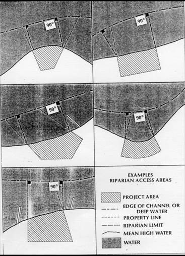
(u) Shared piers or docking facilities shall be allowed, provided that in addition to complying with Paragraphs (a) through (t) of this Rule the following shall also apply:
(1) The shared pier or docking facility shall be confined to two adjacent riparian property owners and the landward point of origination of the structure shall overlap the shared property line;
(2) Shared piers and docking facilities shall be designed to provide docking space for no more than four boats;
(3) The total square footage of shaded impact for docks and mooring facilities shall be calculated using Paragraph (e) of this Rule and in addition shall allow for combined shoreline of both properties;
(4) The property owners of the shared pier shall not be required to obtain a 15-foot waiver from each other as described in Paragraph (q) of this Rule as is applies to the shared riparian line for any work associated with the shared pier, provided that the title owners of both properties have executed a shared pier agreement that has become a part of the permit file; and
(5) The construction of a second access pier or docking facility not associated with the shared pier shall not be authorized under the general permit set forth in this Section.
History Note: Authority G.S. 113A-107(a); 113A-107(b); 113A-113(b); 113A-118.1; 113A-124;
Eff. March 1, 1984;
Amended Eff. December 1, 1991; May 1, 1990; March 1, 1990;
RRC Objection due to ambiguity Eff. March 18, 1993;
Amended Eff. August 1, 1998; April 23, 1993;
Temporary Amendment Eff. December 20, 2001;
Amended Eff. August 1, 2014; July 1, 2009; April 1, 2003;
Readopted Eff. December 1, 2021;
Amended Eff. August 1, 2022.
section .1300 – general permit to construct boat ramps along estuarine and public trust shorelines and into estuArine and public trust waters
15A NCAC 07H .1301 PURPOSE
A person requesting the construction of boat ramps along estuarine and public trust shorelines and into Estuarine and Public Trust Waters AECs shall apply for a General Permit according to the rules in this Section. This permit shall not apply to oceanfront shorelines or to waters and shorelines adjacent to the Ocean Hazard AEC with the exception of those shorelines that feature characteristics of the Estuarine Shoreline AEC. Such features include the presence of wetland vegetation, lower wave energy, and lower erosion rates than the adjacent Ocean Erodible Area.
History Note: Authority G.S. 113A‑107(a); 113A‑107(b); 113A‑113(b); 113A‑118.1; 113A‑124;
Eff. March 1, 1984;
Amended Eff. April 1, 2003; August 1, 2000;
Readopted Eff. October 1, 2022.
15A NCAC 07H .1302 APPROVAL PROCEDURES
(a) An applicant for a General Permit under this Subchapter shall contact the Division of Coastal Management at the Regional Office indicated on the map located at https://ncdenr.maps.arcgis.com/apps/webappviewer/index.html?id=1a5881ec85ca40679988982e02665b51 and request approval for development as defined in G.S. 113A-130(5).
(b) The applicant shall provide:
(1) the site location, dimensions of the project area, and his or her name and address; and
(2) confirmation that a written statement has been obtained, signed by the adjacent riparian property owners, indicating that they have no objections to the proposed work; or
(3) confirmation that the adjacent riparian property owners have been notified by certified mail of the proposed work. The notice shall instruct adjacent property owners to provide any comments on the proposed development in writing to the Division of Coastal Management within ten days of receipt of the notice and indicate that no response by the adjacent property owners shall be interpreted as the adjacent property owners having no objection. Division staff shall review all comments and determine, based on their relevance to the potential impacts of the proposed project, if the proposed project can be approved by a General Permit. If Division staff finds that the comments are worthy of more in-depth review, the Division shall notify the applicant that he or she must submit an application for a major development permit.
(c) No work shall begin until an on‑site meeting is held with the applicant and a Division of Coastal Management representative to review the proposed development. A permit to proceed with the proposed development shall be issued if the Division representative finds that the application meets all the requirements of this Subchapter. Construction permitted under this Section shall be completed within 120 days of permit issuance or such permit shall expire. If the applicant seeks a new permit under this Section, the Division of Coastal Management shall re-examine the proposed development to determine if the General Permit may be reissued.
History Note: Authority G.S. 113A‑107(a); 113A‑107(b); 113A‑113(b); 113A‑118.1; 113A‑124;
Eff. March 1, 1984;
Amended Eff. August 1, 2007; September 1, 2006; January 1, 1990;
Readopted Eff. October 1, 2022.
15A NCAC 07H .1303 PERMIT FEE
The applicant shall pay a permit fee of four hundred ($400.00) by check or money order payable to the Department of Environmental Quality.
History Note: Authority G.S. 113A‑107; 113A‑113(b); 113A‑118.1; 113A‑119; 113A-119.1; 113A‑124;
Eff. March 1, 1984;
Amended Eff. September 1, 2006; August 1, 2000; March 1, 1991;
Readopted Eff. October 1, 2022;
Amended Eff. January 1, 2024.
15A NCAC 07H .1304 GENERAL CONDITIONS
(a) Structures authorized by this permit shall be non‑commercial boat ramps constructed of acceptable material and conforming to the standards herein.
(b) Permittees shall allow authorized representatives of the Department of Environmental Quality to make inspections at any time in order to ensure that the activity being performed under authority of the General Permit set forth in this Section is in accordance with the terms and conditions prescribed herein.
(c) There shall be no interference with navigation or use of the waters by the public through the existence of boat ramps.
(d) The permit set forth in this Section shall not be applicable to proposed construction where the Department has determined based on an initial review of the application that notice and review pursuant to G.S. 113A-119 is required because there are unresolved questions concerning the proposed activity's impact on Areas of Environmental Concern.
History Note: Authority G.S. 113A‑107(a); 113A‑107(b); 113A‑113(b); 113A‑118.1; 113A‑124;
Eff. March 1, 1984;
Amended Eff. May 1, 1990;
RRC Objection due to ambiguity Eff. May 19, 1994;
Amended Eff. August 1, 1998; July 1, 1994;
Readopted Eff. October 1, 2022.
15A NCAC 07H .1305 SPECIFIC CONDITIONS
(a) Boat ramps shall be no wider than 15 feet and shall not extend more than 20 feet waterward of the normal high water level or normal water level.
(b) Excavation and ground disturbing activities above and below the normal high water level or normal water level will be limited to that necessary to establish ramp slope and provide a ramp no greater in size than specified by this general permit.
(c) Placement of fill materials below normal high water level, or normal water level, will be limited to the ramp structure and any associated riprap groins. Boat ramps may be constructed of concrete, wood, steel, clean riprap, marl, or any other suitable equivalent materials approved by the Division of Coastal Management. No coastal wetland vegetation shall be excavated or filled at any time during construction.
(d) The permit set forth in this Section allows for up to a six-foot wide launch access dock, fixed or floating, immediately adjacent to a new or existing boat ramp. The length shall be limited to the length of the permitted boat ramp with a maximum length of 20 feet waterward of the normal high water level or normal water level. No permanent slips are authorized by this permit.
(e) Groins shall be allowed as a structural component on one or both sides of a new or existing boat ramp to reduce scouring. The groins shall be limited to the length of the permitted boat ramp with a maximum length of 20 feet waterward of the normal high water level or normal water level.
(f) The height of sheetpile groins shall not exceed one foot above normal high water level or normal water level and the height of riprap groins shall not exceed two feet above normal high water level or normal water level.
(g) Riprap groins shall not exceed a base width of five feet.
(h) Material used for groin construction shall be free from loose dirt or any other pollutant. Riprap material must be of sufficient size to prevent its movement from the approved alignment by wave action or currents.
(i) "L" and "T" sections shall not be allowed at the end of groins.
(j) Groins shall be constructed of granite, marl, concrete without exposed rebar, timber, vinyl sheet pile, steel sheet pile, or other suitable equivalent materials approved by the Division of Coastal Management.
(k) Boat ramps and their associated structures authorized under this permit shall not interfere with the access to any riparian property and shall have a minimum setback of 15 feet between any part of the boat ramp or associated structures and the adjacent property owners' areas of riparian access. The minimum setbacks provided in the rule may be waived by the written agreement of the adjacent riparian owners, or when two adjoining riparian owners are co-applicants. Should the adjacent property be sold before construction of the boat ramp or associated structures commences, the applicant shall obtain a written agreement with the new owner waiving the minimum setback and submit it to the Division of Coastal Management prior to initiating any development of the boat ramp or associated structures authorized under this permit.
History Note: Authority G.S. 113A-107(a); 113A-107(b); 113A-113(b); 113A-118.1; 113A-124;
Eff. March 1, 1984;
Amended Eff. August 1, 2014;
Readopted Eff. October 1, 2022.
SECTION .1400 - GENERAL PERMIT FOR CONSTRUCTION OF GROINS IN ESTUARINE AND PUBLIC TRUST WATERS AND OCEAN HAZARD AREAS
15A NCAC 07H .1401 PURPOSE
A person requesting the construction of groins in the Estuarine and Public Trust Waters AECs shall apply for a General Permit according to the rules in this Section. This general permit shall not apply to the oceanfront shorelines or to waters and shorelines adjacent to the Ocean Hazard AEC with the exception of those shorelines that feature characteristics of the Estuarine Shoreline AEC. Such features include the presence of wetland vegetation, lower wave energy, and lower erosion rates than the adjacent Ocean Erodible Area.
History Note: Authority G.S. 113A‑107(a); 113A‑107(b); 113A‑113(b); 113A‑118.1; 113A-124(c);
Eff. March 1, 1984;
Temporary Amendment Eff. December 1, 2002;
Amended Eff. February 1, 2009; August 1, 2004; April 1, 2003;
Readopted Eff. October 1, 2022.
15A NCAC 07H .1402 APPROVAL PROCEDURES
(a) An applicant for a General Permit under this Subchapter shall contact the Division of Coastal Management at the Regional Office indicated on the map located at https://ncdenr.maps.arcgis.com/apps/webappviewer/index.html?id=1a5881ec85ca40679988982e02665b51 and request approval for development as defined in G.S. 113A-130(5).
(b) The applicant shall provide:
(1) the site location, dimensions of the project area, and his or her name and address; and
(2) confirmation that a written statement has been obtained, signed by the adjacent riparian property owners, indicating that they have no objections to the proposed work; or
(3) confirmation that the adjacent riparian property owners have been notified by certified mail of the proposed work. The notice shall instruct adjacent property owners to provide any comments on the proposed development in writing to the Division of Coastal Management within 10 days of receipt of the notice and shall indicate that no response by the adjacent property owners shall be interpreted as the adjacent property owners having no objection. Division staff of Coastal Management shall review all comments and determine, based on their relevance to the potential impacts of the proposed project, if the proposed project can be approved by a General Permit. If Division staff finds that the comments are worthy of more in-depth review, the Division shall notify the applicant that he or she must submit an application for a major development permit.
(c) No work shall begin until an on-site meeting is held with the applicant and a Division of Coastal Management representative to review the proposed development. A permit to proceed with the proposed development shall be issued if the Division representative finds that the application meets all the requirements of this Subchapter. Construction permitted under this Section shall be completed within 120 days of permit issuance or such permit shall expire. If the applicant seeks a new permit under this Section, the Division of Coastal Management shall re-examine the proposed development to determine if the General Permit may be reissued.
(d) Any modification or addition to the authorized project shall require approval from the Division of Coastal Management in accordance with 15A NCAC 07J .0405.
History Note: Authority G.S. 113A‑107(a); 113A‑107(b); 113A‑113(b); 113A‑118.1; 113A‑124;
Eff. March 1, 1984;
Amended Eff. February 1, 2009; October 1, 2007; August 1, 2004; May 1, 1990; January 1, 1990;
Readopted Eff. October 1, 2022.
15A NCAC 07H .1403 PERMIT FEE
The applicant shall pay a permit fee of four hundred dollars ($400.00) by check or money order payable to the Department of Environmental Quality.
History Note: Authority G.S. 113A‑107; 113A‑113(b); 113A‑118.1; 113A‑119; 113A-119.1; 113A‑124;
Eff. March 1, 1984;
Amended Eff. September 1, 2006; August 1, 2000; March 1, 1991;
Readopted Eff. October 1, 2022;
Amended Eff. January 1, 2024.
15A NCAC 07H .1404 GENERAL CONDITIONS
(a) Structures authorized by a General Permit in this Section shall be timber, sheetpile, or riprap groins.
(b) Permittees shall allow authorized representatives of the Department of Environmental Quality to make inspections at any time in order to ensure that the activity being performed under authority of the General Permit set forth in this Section is in accordance with the terms and conditions prescribed herein.
(c) The placement of groins authorized in this Rule shall not interfere with the established or traditional rights of navigation of the waters by the public.
(d) The permit set forth in this Section shall not be applicable to proposed construction where the Department has determined based on an initial review of the application, that notice and review pursuant to G.S. 113A-119 is required because there are unresolved questions concerning the proposed activity's impact on Areas of Environmental Concern.
History Note: Authority G.S. 113A‑107(a); 113A‑107(b); 113A‑113(b); 113A‑118.1; 113A‑124;
Eff. March 1, 1984;
Amended Eff. May 1, 1990;
RRC Objection due to ambiguity Eff. May 16, 1994;
Amended Eff. August 1, 1998; July 1, 1994;
Temporary Amendment Eff. December 1, 2002;
Amended Eff. February 1, 2009; August 1, 2004;
Readopted Eff. October 1, 2022.
15A NCAC 07H .1405 SPECIFIC CONDITIONS
(a) Groins shall be perpendicular to the shoreline and shall not extend more than 25 feet waterward of the normal high water or normal water level.
(b) Riprap groins shall not exceed a base width of 10 feet.
(c) Groins shall be set back at least 15 feet from the riparian access dividing line as measured from the closest point of the structure. This setback may be waived by written agreement of the adjacent riparian owners or when two adjoining riparian owners are co‑applicants. Should the adjacent property be sold before construction of the groin commences, the applicant shall obtain a written agreement with the new owner waiving the minimum setback and submit it to the Division of Coastal Management prior to initiating any development of the groin.
(d) The height of sheetpile groins shall not exceed one foot above normal high water or the normal water level and the height of riprap groins shall not exceed two feet above normal high water or the normal water level.
(e) Material used for groin construction shall be free from loose dirt. Groin material must be of sufficient size to prevent its movement from the site by wave action or currents.
(f) Structure spacing shall be two times the groin length as measured from the centerline of the structure. Spacing may be less than two times the groin length around channels, docking facilities, boat lifts, or boat ramps and when positioned to prevent sedimentation or accretion around channels, docking facilities, boat lifts, or boat ramps.
(g) "L" and "T" sections shall not be allowed at the end of groins.
(h) Groins shall be constructed of granite, marl, concrete without exposed rebar, timber, vinyl sheet pile, steel sheet pile, or other suitable equivalent materials approved by the Division of Coastal Management.
History Note: Authority G.S. 113A‑107(a); 113A‑107(b); 113A‑113(b); 113A‑118.1; 113A‑124;
Eff. March 1, 1984;
Temporary Amendment Eff. December 1, 2002;
Amended Eff. February 1, 2009; August 1, 2004;
Readopted Eff. October 1, 2022.
SECTION .1500 ‑ GENERAL PERMIT FOR EXCAVATION WITHIN OR CONNECTING TO EXISTING CANALS, CHANNELS, BASINS, OR DITCHES IN ESTUARINE WATERS, PUBLIC TRUST WATERS, AND COASTAL SHORELINE AECS
15A NCAC 07H .1501 PURPOSE
A person requesting excavation within or connecting to existing canals, channels, basins, or ditches in Estuarine Waters, Public Trust Waters, and Coastal Shorelines AECs for the purpose of maintaining water depths and creating new boat basins from non‑wetland areas that will be used for private, non‑commercial activities shall apply for a General Permit according to the rules of this Section.
History Note: Authority G.S. 113A‑107(a),(b); 113A‑113(b); 113A‑118.1; 113‑229(c1);
Eff. July 1, 1984;
Amended Eff. July 1, 2015; December 1, 1987;
Readopted Eff. October 1, 2022.
15A NCAC 07H .1502 APPROVAL PROCEDURES
(a) An applicant for a General Permit under this Subchapter shall contact the Division of Coastal Management at the Regional Office indicated on the map located at https://ncdenr.maps.arcgis.com/apps/webappviewer/index.html?id=1a5881ec85ca40679988982e02665b51 and request approval for development as defined in G.S. 113A-130(5).
(b) The applicant shall provide:
(1) the site location, dimensions of the project area, and his or her name and address; and
(2) confirmation that a written statement has been obtained, signed by the adjacent riparian property owners, indicating that they have no objections to the proposed work; or
(3) confirmation that the adjacent riparian property owners have been notified by certified mail of the proposed work. The notice shall instruct adjacent property owners to provide any comments on the proposed development in writing to the Division of Coastal Management within ten days of receipt of the notice and indicate that no response by the adjacent property owners will be interpreted as the adjacent property owners having no objection. Division staff shall review all comments and determine, based on their relevance to the potential impacts of the proposed project, if the proposed project can be approved by a General Permit. If Division staff finds that the comments are worthy of more in-depth review, the Division shall notify the applicant that he or she must submit an application for a major development permit.
(c) No work shall begin until an onsite meeting is held with the applicant and a Division of Coastal Management representative to review the proposed development. A Permit to proceed with the proposed development shall be issued if the Division representative finds that the application meets all the requirements of this Subchapter. Construction permitted under this Section shall be completed within 120 days of the date of permit issuance or such permit shall expire. If the applicant seeks a new permit under this Section, the Division of Coastal Management shall re-examine the proposed development to determine if the General Permit may be reissued.
History Note: Authority G.S. 113A‑107(a),(b); 113A‑113(b); 113A‑118.1; 113-229(c1);
Eff. July 1, 1984;
Amended Eff. July 1, 2015; January 1, 1990; December 1, 1987;
Readopted Eff. October 1, 2022.
15A NCAC 07H .1503 APPLICATION FEE
The applicant shall pay a permit fee of four hundred dollars ($400.00) for maintenance excavation up to 1,000 cubic yards. Permit fees shall be paid by check or money order payable to the Department of Environmental Quality.
History Note: Authority G.S. 113-229; 113A‑107; 113A‑118.1; 113A‑119; 113A-119.1; 113A‑124;
Eff. July 1, 1984;
Amended Eff. September 1, 2006; August 1, 2000; March 1, 1991;
Readopted Eff. October 1, 2022;
Amended Eff. January 1, 2024.
15A NCAC 07H .1504 GENERAL CONDITIONS
(a) Permittees shall allow representatives of the Department of Environmental Quality to make inspections at any time to ensure that the activity being performed under authority of the General Permit set forth in this Section is in accordance with the terms and conditions prescribed herein.
(b) The permit set forth in this Section shall not be applicable to proposed construction where the Department has determined based on an initial review of the application that notice and review pursuant to G.S. 113A-119 is required because there are unresolved questions concerning the proposed activity's impact on Areas of Environmental Concern.
(c) No new basins shall be allowed that result in closure of shellfish waters according to the closure policy of the Division of Marine Fisheries, 15A NCAC 18A .0911.
History Note: Authority G.S. 113A‑107(a),(b); G.S. 113A-108; 113A‑113(b); 113A‑118.1; 113-229(c1);
Eff. July 1, 1984;
Amended Eff. May 1, 1990; December 1, 1987;
RRC Objection due to ambiguity Eff. May 19, 1994;
Amended Eff. July 1, 2015; August 1, 1998; July 1, 1994;
Readopted Eff. October 1, 2022.
15A NCAC 07H .1505 SPECIFIC CONDITIONS
Proposed maintenance excavation shall meet each of the following specific conditions to be eligible for authorization by this general permit.
(1) New basins shall be allowed only when they are located entirely in highground and join existing man‑made canals or basins.
(2) New basins shall be no larger than 50 feet in either length or width and no deeper than the waters they join.
(3) New basins shall be for the private non‑commercial use of the land owner.
(4) Maintenance excavation shall involve the removal of no more than 1,000 cubic yards of material as part of a single and complete project.
(5) All excavated material shall be placed entirely on high ground above the mean high tide or ordinary high water line, and above any marsh, or other wetland.
(6) All spoil material shall be stabilized or retained so as to prevent any excavated material from re‑entering the surrounding waters, marsh, or other wetlands.
(7) The proposed project shall not involve the excavation of any marsh, submerged aquatic vegetation as defined at 15A NCAC 03I .0101 by the Marine Fisheries Commission, or other wetlands.
(8) Maintenance excavation shall not exceed the original dimensions of the canal, channel, basin, or ditch and in no case be deeper than 6 feet below mean low water or ordinary low water, nor deeper than connecting channels.
(9) Proposed excavation in existing channels and basins shall not allow for a public or commercial use.
(10) Maintenance excavation as well as excavation of new basins shall not be allowed within or with connections to primary nursery areas without prior approval from the Division of Marine Fisheries or Wildlife Resources Commission.
(11) Bulkheads shall be allowed as a structural component on one or more sides of the permitted basin to stabilize the shoreline from erosion.
(12) The bulkhead shall not exceed a distance of two feet waterward of the normal high water or normal water level at any point along its alignment.
(13) Bulkheads shall be constructed of vinyl or steel sheet pile, concrete, stone, timber, or other materials approved by the Division of Coastal Management.
(14) All backfill material shall be obtained from an upland source pursuant to 15A NCAC 07H .0208. The bulkhead shall be constructed prior to any backfilling activities and shall be constructed so as to prevent seepage of backfill materials through the structure.
(15) Construction of bulkhead authorized by this general permit in conjunction with bulkhead authorized under 15A NCAC 07H .1100 shall be limited to a combined maximum shoreline length of 500 feet.
History Note: Authority G.S. 113A‑107(a),(b); 113A‑108; 113A‑113(b); 113A‑118.1; 113-229(c1);
Eff. July 1, 1984;
Amended Eff. July 1, 2015; September 1, 1988; December 1, 1987;
Readopted Eff. October 1, 2022.
SECTION .1600 ‑ GENERAL PERMIT FOR THE INSTALLATION OF AERIAL AND SUBAQUEOUS UTILITY LINES WITH ATTENDANT STRUCTURES IN COASTAL WETLANDS: ESTUARINE WATERS: PUBLIC TRUST WATERS AND ESTUARINE SHORELINES
15A NCAC 07H .1601 PURPOSE
A person requesting the installation of utility lines both aerially and subaqueously in the Coastal Wetland, Estuarine Waters, Public Trust Areas, and Estuarine and Public Trust Shoreline AECs shall apply for a General Permit according to rules in this Section. This general permit shall not apply to the ocean hazard AECs.
History Note: Authority G.S. 113A‑107(a)(b); 113A‑113(b); 113A‑118.1; 113-229(c1);
Eff. March 1, 1985;
Amended Eff. August 1, 2000; August 1, 1998;
Readopted Eff. October 1, 2022.
15A NCAC 07H .1602 APPROVAL PROCEDURES
(a) An applicant for a General Permit under this Subchapter shall contact the Division of Coastal Management at the Regional Office indicated on the map located at https://ncdenr.maps.arcgis.com/apps/webappviewer/index.html?id=1a5881ec85ca40679988982e02665b51 and request approval for development as defined in G.S. 113A-130(5).
(b) The applicant shall provide:
(1) the site location, dimensions of the project area, and his or her name and address; and
(2) confirmation that a written statement has been obtained, signed by the adjacent riparian property owners, indicating that they have no objections to the proposed work; or
(3) confirmation that the adjacent riparian property owners have been notified by certified mail of the proposed work. The notice shall instruct adjacent property owners to provide any comments on the proposed development in writing to the Division of Coastal Management within ten days of receipt of the notice and indicate that no response by the adjacent property owners will be interpreted as the adjacent property owners having no objection. Division staff shall review all comments and determine, based on their relevance to the potential impacts of the proposed project, if the proposed project can be approved by a General Permit. If Division staff finds that the comments are worthy of more in‑depth review, the Division shall notify the applicant that he or she must submit an application for a major development permit.
(c) No work shall begin until an on‑site meeting is held with the applicant and a Division of Coastal Management representative to review the proposed development. A Permit to proceed with the proposed development shall be issued if the Division representative finds that the application meets all the requirements of this Subchapter. Construction permitted under this Section shall begin within twelve months of the date of permit issuance or such permit shall expire. If the applicant seeks a new permit under this Section, the Division of Coastal Management shall re-examine the proposed development to determine if the General Permit may be reissued.
History Note: Authority G.S. 113A‑107(a)(b); 113A‑113(b); 113A‑118.1; 113-229(c1);
Eff. March 1, 1985;
Amended Eff. January 1, 1990;
Readopted Eff. October 1, 2022.
15A NCAC 07H .1603 PERMIT FEE
The applicant shall pay a permit fee of four hundred dollars ($400.00) by check or money order payable to the Department of Environmental Quality.
History Note: Authority G.S. 113A‑107; 113A‑113(b); 113A‑118.1; 113A‑119; 113A-119.1; 113-229(c1);
Eff. March 1, 1985;
Amended Eff. September 1, 2006; August 1, 2000; March 1, 1991;
Readopted Eff. October 1, 2022.
15A NCAC 07H .1604 GENERAL CONDITIONS
(a) Utility lines for the purpose of this General Permit are any pipes or pipelines for the transportation of potable water, domestic sanitary sewage, natural gas, and any cable, line, or wire for the transmission, of electrical energy, telephone and telegraph messages, and radio and television communication.
(b) There shall be no alteration of preconstruction bottom contours. Fill authorized by a permit set forth in this Section shall include only that necessary to backfill or bed the utility line. Any excess material shall be removed to an upland disposal area.
(c) The utility line crossing shall not adversely affect a public water supply intake.
(d) The utility line route or construction method shall not disrupt the movement of those species of aquatic life indigenous to the waterbody.
(e) Permittees shall allow authorized representatives of the Department of Environmental Quality to make inspections at any time to ensure that the activity being performed under authority of the General Permit set forth in this Section is in accordance with the terms and conditions prescribed herein.
(f) The permit set forth in this Section shall not be applicable to proposed construction where the Department has determined based on an initial review of the application, that notice and review pursuant to G.S. 113A-119 is required because there are unresolved questions concerning the proposed activity impact on Areas of Environmental Concern.
History Note: Authority G.S. 113A‑107(a)(b); 113A‑113(b); 113A‑118.1; 113-229(c1);
Eff. March 1, 1985;
Amended Eff. May 1, 1990;
RRC Objection due to ambiguity Eff. May 19, 1994;
Amended Eff. August 1, 1998; July 1, 1994;
Readopted Eff. October 1, 2022.
15A NCAC 07H .1605 SPECIFIC CONDITIONS
Proposed utility line installations shall meet each of the following specific conditions to be eligible for authorization by this General Permit:
(1) All domestic sanitary sewer line requests must be accompanied by a statement of prior approval from the NC Division Water Quality.
(2) All spoils which are permanently removed must be placed on a high ground disposal site and stabilized so as not to return to waters, marsh, or other wetlands.
(3) Any additional backfill material required shall consist of sand or rock and not contain organic matter.
(4) Finished grades or subaqueous or wetland crossing must be returned to preproject contours.
(5) There can be no work within any productive shellfish beds.
(6) No excavation or filling activities will be permitted between April 1 and September 30 of any year within any designated primary nursery area.
(7) Subaqueous lines must be placed at a depth of six feet below the project depth of federal projects. For non-federal projects, subaqueous lines shall be installed at a minimum depth of two feet below the bottom contour.
(8) The minimum clearance for aerial communication lines or any lines not transmitting electricity shall be 10 feet above the clearance required for bridges in the vicinity.
(9) The minimum clearance for aerial electrical transmission lines shall be consistent with those established by the US Army Corps of Engineers and US Coast per 33 CFR 322.5 (i).
(10) The installation of a utility line on pipe bents or otherwise above the elevation of mean high or mean ordinary water must be of sufficient height to allow for traditional navigation in the water body. The utility line shall not interfere with the waterflow of normal or flood waters.
(11) Natural gas lines shall not exceed 11 inches in diameter.
History Note: Authority G.S. 113A‑107(a)(b); 113A‑113(b); 113A‑118.1; 113-229(c1);
Eff. March 1, 1985;
Amended Eff. August 1, 1998;
Readopted Eff. October 1, 2022.
SECTION .1700 ‑ GENERAL PERMIT FOR EMERGENCY WORK REQUIRING A CAMA AND/OR A DREDGE AND FILL PERMIT
15A NCAC 07H .1701 PURPOSE
This permit allows work necessary to protect property or prevent further damage to property caused by a sudden or unexpected natural event or structural failure which imminently endangers life or structure. For the purposes of this general permit, major storms such as hurricanes, northeasters, or southwesters may be considered a sudden unexpected natural event although such storms may be predicted and publicized in advance.
History Note: Authority G.S. 113‑229(cl); 113A‑107(a),(b); 113A‑113(b); 113A‑118.1;
Eff. November 1, 1985;
Readopted Eff. July 1, 2022.
15A NCAC 07H .1702 APPROVAL PROCEDURES
(a) Any person wishing to undertake development in an area of environmental concern necessary to protect life or endangered structures will notify the Division of Coastal Management or Local Permit Office (LPO) when a possible emergency situation exists.
(b) The applicant may qualify for approval of work described in this permit after an onsite inspection by the LPO or Division of Coastal Management Field Consultant and upon his or her findings that the proposed emergency work requires a CAMA or Dredge and Fill permit. The LPO shall issue the permit if the required emergency measures constitute minor development in accordance with G.S. 113A-118(2).
(c) Once the LPO or Consultant determines that the applicant's proposed project may qualify for an emergency permit, he or she shall consult with the applicant and assist him or her in preparing an application. The applicant shall include a sketch showing existing conditions and the proposed work.
(d) The applicant for an emergency permit shall take all reasonable steps to notify adjacent riparian landowners of the application, and prior to receiving a permit will certify by signing the permit the following:
(1) that a copy of the application and sketch has been served on all adjacent riparian landowners, or if service of a copy was not feasible, that the applicant has explained the project to all adjacent riparian landowners;
(2) that the applicant has explained to all adjacent riparian landowners that they have a right to oppose the issuance of a permit by filing objections with the local CAMA permit officer or with the Secretary of the Department of Environmental Quality; and
(3) that, as to adjacent riparian landowners not contacted, the applicant has made a reasonable attempt to contact them and furnish them with the required information.
(e) All work authorized by this general permit will cease after thirty days from the date of issuance.
History Note: Authority G.S. 113‑229(cl); 113A‑107(a),(b); 113A‑113(b); 113A‑118.1;
Eff. November 1, 1985;
Amended Eff. May 1, 1990;
Readopted Eff. July 1, 2022.
15A NCAC 07H .1703 PERMIT FEE
The agency shall not charge a fee for permitting work necessary to respond to emergency situations except in the case when a temporary erosion control structure is used. In those cases, the applicant shall pay a permit fee of four hundred dollars ($400.00) by check or money order made payable to the Department.
History Note: Authority G.S. 113-229(cl); 113A-107(a),(b); 113A-113(b); 113A-118.1; 113A-119;
Eff. November 1, 1985;
Amended Eff. September 1, 2006; August 1, 2002; March 1, 1991; October 1, 1993;
Readopted Eff. July 1, 2022.
15A NCAC 07H .1704 GENERAL CONDITIONS
(a) Work permitted by means of an emergency general permit shall be subject to the following limitations:
(1) No work shall begin until an onsite meeting is held with the applicant and a Division of Coastal Management representative so that the scope of the proposed emergency work can be delineated.
(2) No work shall be permitted other than that which is necessary to protect against or reduce the imminent danger caused by the emergency, to restore the damaged property to its condition immediately before the emergency, or to re-establish public facilities or transportation corridors.
(3) Any permitted temporary erosion control projects shall be located no more than 20 feet waterward of the imminently threatened structure or the right-of way in the case of roads, except as provided under 15A NCAC 07H .0308. If a building or road is found to be imminently threatened and at increased risk of imminent damage due to site conditions, such as a flat beach profile or accelerated erosion, temporary erosion control structures may be located more than 20 feet waterward of the structure being protected. In cases of increased risk of imminent damage, the location of the temporary erosion control structures shall be determined by the Director of the Division of Coastal Management or the Director's designee.
(4) Fill materials used in conjunction with emergency work for storm or erosion control shall be obtained from an upland source. Excavation below MHW in the Ocean Hazard AEC may be allowed to obtain material to fill sandbags used for emergency protection.
(5) This emergency general permit allows the use of oceanfront erosion control measures for all oceanfront properties without regard to the size of the existing structure on the property or the date of construction.
(b) Individuals shall allow authorized representatives of the Department of Environmental Quality to make inspections to ensure that the activity being performed under authority of this emergency general permit is in accordance with these Rules.
(c) Development shall not jeopardize the use of the waters for navigation or for other public trust rights in public trust areas including estuarine waters.
(d) This permit shall not be applicable to proposed construction where the Department has determined, based on an initial review of the application, that notice and review pursuant to G.S. 113A-119 is necessary because there are unresolved questions concerning the proposed activity's impact on adjoining properties or on water quality, air quality, coastal wetlands, cultural or historic sites, wildlife, fisheries resources, or public trust rights.
(e) This permit does not eliminate the need to obtain any other state, local, or federal authorization.
(f) Development carried out under this permit must be consistent with all local requirements, CAMA rules, and local land use plans, storm hazard mitigation, and post-disaster recovery plans current at the time of authorization.
History Note: Authority G.S. 113-229(cl); 113A-107(a),(b); 113A-113(b); 113A-118; 113A-118.1;
Eff. November 1, 1985;
Amended Eff. December 1, 1991; May 1, 1990;
RRC Objection due to ambiguity Eff. May 19, 1994;
Amended Eff. April 1, 2019; May 1, 2010; August 1, 1998; July 1, 1994;
Readopted Eff. July 1, 2022.
15A NCAC 07H .1705 SPECIFIC CONDITIONS
(a) Temporary Erosion Control Structures in the Ocean Hazard AEC.
(1) Permittable temporary erosion control structures shall be limited to sandbags placed landward of mean high water and parallel to the shore.
(2) Temporary erosion control structures as defined in Subparagraph (1) of this Paragraph may be used to protect only imminently threatened roads and associated right of ways, and buildings and their associated septic systems. A structure is considered imminently threatened if its foundation, septic system, or right-of-way in the case of roads is less than 20 feet away from the erosion scarp. Buildings and roads located more than 20 feet from the erosion scarp or in areas where there is no obvious erosion scarp may also be found to be imminently threatened when the Division determines that site conditions, such as a flat beach profile or accelerated erosion, increase the risk of imminent damage to the structure.
(3) Temporary erosion control structures shall be used to protect only the principal structure and its associated septic system, but not appurtenances such as pools, gazebos, decks or any amenity that is allowed under 15A NCAC 07H .0309 as an exception to the erosion setback requirement.
(4) Temporary erosion control structures may be placed waterward of a septic system when there is no alternative to relocate it on the same or adjoining lot so that it is landward of or in line with the structure being protected.
(5) Temporary erosion control structures shall not extend more than 20 feet past the sides of the structure to be protected except to align with temporary erosion control structures on adjacent properties, where the Division has determined that gaps between adjacent erosion control structures may result in an increased risk of damage to the structure being protected. The landward side of such temporary erosion control structures shall not be located more than 20 feet waterward of the structure to be protected or the right-of-way in the case of roads. If a building or road is found to be imminently threatened and at increased risk of imminent damage due to site conditions such as a flat beach profile or accelerated erosion, temporary erosion control structures may be located more than 20 feet waterward of the structure being protected. In cases of increased risk of imminent damage, the location of the temporary erosion control structures shall be determined by the Director of the Division of Coastal Management or the Director's designee.
(6) Temporary erosion control structures may remain in place for up to eight years for a building and its associated septic system, or a bridge or a road. The property owner shall be responsible for removal of any portion of the temporary erosion control structure exposed above grade within 30 days of the end of the allowable time period.
(7) For purposes of this Rule, a community is considered to be actively pursuing a beach nourishment or an inlet relocation or stabilization project if it:
(A) has an active CAMA permit, where necessary, approving such project;
(B) has been identified by a U.S. Army Corps of Engineers' Beach Nourishment Reconnaissance Study, General Reevaluation Report, Coastal Storm Damage Reduction Study, or an ongoing feasibility study by the U.S. Army Corps of Engineers and a commitment of local or federal money, when necessary; or
(C) has received a favorable economic evaluation report on a federal project; or
(D) is in the planning stages of a project designed by the U.S. Army Corps of Engineers or persons meeting applicable State occupational licensing requirements and initiated by a local government or community with a commitment of local or state funds to construct the project or the identification of the financial resources or funding bases necessary to fund the beach nourishment or inlet relocation or stabilization project.
If beach nourishment, inlet relocation or stabilization is rejected by the sponsoring agency or community, or ceases to be actively planned for a section of shoreline, the time extension is void for that section of beach or community and existing sandbags shall be subject to all applicable time limits set forth in Subparagraph (6) of this Paragraph.
(8) Once a temporary erosion control structure is determined by the Division of Coastal Management to be unnecessary due to relocation or removal of the threatened structure, it shall be removed by the property owner to the maximum extent practicable within 30 days of official notification from the Division of Coastal Management, regardless of the time limit placed on the temporary erosion control structure. If the temporary erosion control structure is determined by the Division of Coastal Management to be unnecessary due to the completion of a storm protection project constructed by the U.S. Army Corps of Engineers, a large scale beach nourishment project, or an inlet relocation or stabilization project, any portion of the temporary erosion control structure exposed above grade shall be removed by the permittee within 30 days of official notification by the Division of Coastal Management regardless of the time limit placed on the temporary erosion control structure.
(9) Removal of temporary erosion control structures is not required if they are covered by sand. Any portion of a temporary erosion control structure that becomes exposed above grade after the expiration of the permitted time period shall be removed by the property owner within 30 days of official notification from the Division of Coastal Management.
(10) The property owner shall be responsible for the removal of remnants of all portions of any damaged temporary erosion control structure.
(11) Sandbags used to construct temporary erosion control structures shall be tan in color and 3 to 5 feet wide and 7 to 15 feet long when measured flat. Base width of the structure shall not exceed 20 feet, and the total height shall not exceed 6 feet, as measured from the bottom of the lowest bag.
(12) Soldier pilings and other types of devices to anchor sandbags shall not be allowed.
(13) Excavation below mean high water in the Ocean Hazard AEC may be allowed to obtain material to fill sandbags used for emergency protection.
(14) An imminently threatened structure may be protected by a temporary erosion control structure only once regardless of ownership, unless the threatened structure is located in a community that is actively pursuing a beach nourishment project, an inlet relocation or stabilization project in accordance with Subparagraph (7) of this Paragraph. Existing temporary erosion control structures may be permitted for additional eight-year periods provided that the structure being protected is still imminently threatened, the temporary erosion control structure is in compliance with requirements of this Subparagraph, and the community in which it is located is actively pursuing a beach nourishment or an inlet relocation or stabilization project in accordance with Subparagraph (7) of this Paragraph. In the case of a building, a temporary erosion control structure may be extended, or new segments constructed, if additional areas of the building become imminently threatened. Where temporary structures are installed or extended incrementally, the time period for removal under Subparagraph (6) or (7) of this Paragraph shall begin at the time the initial erosion control structure is installed. For the purpose of this Rule:
(A) a building and its associated septic system shall be considered as separate structures; and
(B) a road or highway shall be allowed to be incrementally protected as sections become imminently threatened. The time period for removal of each contiguous section of sandbags shall begin at the time that section is installed in accordance with Subparagraph (6) or (7) of this Paragraph.
(15) Existing temporary erosion control structures may be repaired or replaced within their originally permitted dimensions during the time period allowed under Subparagraph (6) or (7) of this Paragraph.
(b) Erosion Control Structures in the Estuarine Shoreline, Estuarine Waters, and Public Trust AECs. Work permitted by this Rule shall be subject to the following limitations:
(1) The erosion control structure shall be located no more than 20 feet waterward of the imminently threatened structure. If a building or road is found to be imminently threatened and at increased risk of imminent damage due to site conditions such as a flat shore profile or accelerated erosion, temporary erosion control structures may be located more than 20 feet waterward of the structure being protected. In cases of increased risk of imminent damage, the location of the temporary erosion control structures shall be determined by the Director of the Division of Coastal Management or the Director's designee.
(2) Fill material used in conjunction with emergency work for storm or erosion control in the Estuarine Shoreline, Estuarine Waters, and Public Trust AECs shall be obtained from an upland source.
(c) Protection, Rehabilitation, or Temporary Relocation of Public Facilities or Transportation Corridors. This permit authorizes only the immediate protection or temporary rehabilitation or relocation of existing public facilities. Long-term stabilization or relocation of public facilities shall be consistent with local governments' post-disaster recovery plans and policies which are part of their Land Use Plans.
(1) Work permitted by this general permit shall be subject to the following limitations:
(A) no work shall be permitted other than that which is necessary to protect against or reduce the imminent danger caused by the emergency or to restore the damaged property to its condition immediately before the emergency;
(B) the erosion control structure shall be located no more than 20 feet waterward of the imminently threatened structure or the right-of-way in the case of roads. If a public facility or transportation corridor is found to be imminently threatened and at increased risk of imminent damage due to site conditions such as a flat shore profile or accelerated erosion, temporary erosion control structures may be located more than 20 feet waterward of the facility or corridor being protected. In cases of increased risk of imminent damage, the location of the temporary erosion control structures shall be determined by the Director of the Division of Coastal Management or the Director's designee in accordance with Subparagraph (a)(1) of this Rule;
(C) any fill materials used in conjunction with emergency work for storm or erosion control shall be obtained from an upland source except that dredging for fill material to protect public facilities or transportation corridors shall be considered in accordance with standards in 15A NCAC 07H .0208; and
(D) all fill materials or structures associated with temporary relocations which are located within Coastal Wetlands, Estuarine Water, or Public Trust AECs shall be removed after the emergency event has ended and the area restored to pre-disturbed conditions.
History Note: Authority G.S. 113-229(cl); 113A-107(a),(b); 113A-113(b); 113A-115.1; 113A-118.1;
Eff. November 1, 1985;
Amended Eff. April 1, 1999; February 1, 1996; June 1, 1995;
Temporary Amendment Eff. July 3, 2000; May 22, 2000;
Amended Eff. April 1, 2019; May 1, 2013; May 1, 2010; August 1, 2002;
Readopted Eff. July 1, 2022.
SECTION .1800 ‑ GENERAL PERMIT TO ALLOW BEACH BULLDOZING IN THE OCEAN HAZARD AEC
15A NCAC 07H .1801 PURPOSE
This permit will allow beach bulldozing needed to reconstruct or repair dune systems, as defined in Rule .0305 of this Subchapter. For the purpose of this general permit, "beach bulldozing" is defined as the process of moving natural beach material from any point seaward of the first line of stable vegetation to repair damage to frontal or primary dunes. This general permit is subject to the procedures outlined in Subchapter 07J .1100, and shall not apply where a town or community has a Major Permit for either an ongoing beach bulldozing project or project completed within 30 days of a request for a General Permit.
History Note: Authority G.S. 113‑229(cl); 113A-107;113A‑113(b); 113A‑118.1;
Eff. December 1, 1987;
Amended Eff. September 1, 2016;
Readopted Eff. April 1, 2022;
Amended Eff. August 1, 2022.
15A NCAC 07H .1802 APPROVAL PROCEDURES
(a) An applicant for a General Permit under this Subchapter shall contact the Division of Coastal Management and request approval for development.
(b) The applicant shall provide:
(1) the site location, dimensions of the project area, and their name and address;
(2) Confirmation that a written statement has been obtained signed by the adjacent riparian property owners indicating that they have no objections to the proposed work; or
(3) confirmation that the adjacent riparian property owners have been notified by certified mail of the proposed work. The notice shall instruct adjacent property owners to provide any comments on the proposed development in writing for consideration by permitting official to the Division of Coastal Management within 10 days of receipt of the notice and indicate that no response wil be interpreted as no objection. Division staff shall review all comments and determine, based on their relevance to the potential impacts of the proposed project, if the proposed project can be approved by a General Permit. If Division staff determines that the project exceeds the guidelines established by the General Permit process provided in 15A NCAC 07J .1100, Division staff shall notify the applicant that they must submit an application for a major development permit.
(c) No work shall begin until an on‑site meeting is held with the applicant and DCM representative. All bulldozing shall be completed within 30 days of the date of permit issuance.
History Note: Authority G.S. 113-229(c1); 113-229(c2); 113A-107; 113A‑113(b); 113A‑118.1;113A-120;
Eff. December 1, 1987;
Amended Eff. September 1, 2016; January 1, 1990;
Readopted Eff. April 1, 2022.
15A NCAC 07H .1803 PERMIT FEE
The applicant shall pay a permit fee of four hundred dollars ($400.00) by check or money order payable to the Department.
History Note: Authority G.S. 113‑229(c1); 113A‑107; 113A‑113(b); 113A‑118.1; 113A‑119; 113A-119.1;
Eff. December 1, 1987;
Amended Eff. September 1, 2006; August 1, 2000; March 1, 1991;
Readopted Eff. April 1, 2022.
15A NCAC 07H .1804 GENERAL CONDITIONS
(a) This General Permit shall not be applicable to proposed construction where the Division of Coastal Management has determined, based on an initial review of the application, that notice and review pursuant to G.S. 113A-119 is necessary because there are unresolved questions concerning the proposed activity's impact on adjoining properties or on water quality, air quality, coastal wetlands, cultural or historic sites, wildlife, fisheries resources, or public trust rights. If a shipwreck is unearthed, all work shall stop immediately and the Division of Coastal Management shall be contacted.
(b) This General Permit shall not eliminate the need to obtain any other required State, local, or federal authorization.
(c) Development carried out under a permit as set forth in this Section shall be consistent with all State, federal and local requirements, and local Land Use Plans in effect at the time of authorization.
History Note: Authority G.S. 113-229(c1); 113A-102(b)(4)(e); 113A-107;113A‑113(b); 113A‑118.1;
Eff. December 1, 1987;
Amended Eff. May 1, 1990;
RRC Objection due to ambiguity Eff. May 19, 1994;
Amended Eff. September 1, 2016; August 1,1998; July 1, 1994;
Readopted Eff. April 1, 2022.
15A nCAC 07H .1805 SPECIFIC CONDITIONS
(a) The area where beach bulldozing is being performed shall maintain a slope that follows the pre-emergency slopes as closely as possible so as not to endanger the public or the public's use of the beach. The movement of material by a bulldozer, front‑end loader, backhoe, scraper, or any type of earth moving or construction equipment shall not exceed one foot in depth measured from the pre‑activity surface elevation.
(b) The activity shall not exceed the lateral bounds of the applicant's property without the written permission of the adjoining landowner(s).
(c) The permit shall not authorize movement of material from seaward of the mean low water line.
(d) Adding sand to dunes shall be accomplished in such a manner that the damage to existing vegetation is minimized. Upon completion of the project, the fill areas shall be replanted with native vegetation, such as Sea Oats (Uniola paniculata), or if outside the planting season, shall be stabilized with sand fencing until planting can occur.
(e) In order to minimize adverse impacts to threatened and endangered species, no bulldozing shall occur inside the Ocean Hazard AEC within the period of April 1 through November 15 of any year, or anytime inside an Inlet Hazard AEC without the prior approval of the Division of Coastal Management, in coordination with the North Carolina Wildlife Resources Commission, the United States Fish and Wildlife Service, and the United States Army Corps of Engineers.
(f) If one contiguous acre or more of oceanfront property is to be excavated or filled, an erosion and sedimentation control plan shall be filed with and approved by the Division of Energy, Mineral, and Land Resources, or local government having jurisdiction. This plan must be approved prior to commencing the land disturbing activity.
History Note: Authority G.S. 113-229(c1); 113A-107; 113A‑113(b); 113A‑118.1;
Eff. December 1, 1987;
Temporary Amendment Eff. September 2, 1998;
Amended Eff. September 1, 2016; August 1, 2012 (see S.L. 2012-143, s.1.(f)); August 1, 2000;
Readopted Eff. April 1, 2022;
Amended Eff. September 1, 2022.
section .1900 – general permit to allow for temporary stRuctures within THE ESTUARINE and ocean SYSTEMS aecs
15A NCAC 07H .1901 PURPOSE
A permit under this Section shall allow for the placement of temporary structures within the estuarine and ocean systems AECs according to the provisions provided in 15A NCAC 07J .1100 and according to the rules in this Section.
History Note: Authority G.S. 113‑229(c1); 113A‑107(a)(b); 113A‑113(b); 113A‑118.1;
Eff. March 1, 1989;
Amended Eff. April 1, 2020; August 1, 2000;
Readopted Eff. July 1, 2022.
15A NCAC 07H .1902 APPROVAL PROCEDURES
(a) The applicant shall contact the Division of Coastal Management at the address provided in 15A NCAC 07A .0101 and complete an application requesting approval for development. For temporary structures associated with scientific research, permit applicants shall be lead investigators on behalf of accredited educational institutions, or state or federal agencies.
(b) If a temporary structure is to be located less than 400 feet waterward of normal high water or normal water level, or within the established pier head line as determined by the Division of Coastal Management, the applicant shall provide:
(1) a written statement signed by the adjacent riparian property owners indicating that they have no objections to the proposed work; or
(2) confirmation that the adjacent riparian property owners have been notified by certified mail of the proposed work. Such notice should instruct adjacent property owners to provide any comments on the proposed development in writing for consideration by permitting officials to the Division of Coastal Management within ten days of receipt of the notice, and indicate that no response will be interpreted as no objection. DCM staff will review all comments and determine, based on their relevance to the potential impacts of the proposed project, if the proposed project can be approved by a General Permit. If DCM determines that the project exceeds the conditions established by this General Permit, DCM shall notify the applicant that a Major Permit application shall be required.
(c) No work shall begin until an onsite meeting is held with the applicant and a Division of Coastal Management representative to inspect and mark the site of construction of the proposed development. Temporary structures authorized by this General Permit may remain in place for a maximum of one year from the date of issuance. The project site shall be restored to pre-development conditions and all structures shall be removed within one year of permit issuance, or by the date specified with the General Permit.
History Note: Authority G.S. 113‑229(cl); 113A‑107(a)(b); 113A‑113(b); 113A‑118.1;
Eff. March 1, 1989;
Amended Eff. April 1, 2020; January 1, 1990;
Readopted Eff. July 1, 2022.
15A NCAC 07H .1903 PERMIT FEE
The applicant shall pay a permit fee of four hundred dollars ($400.00) by check or money order payable to the Department of Environmental Quality.
History Note: Authority G.S. 113‑229(c1); 113A‑107; 113A‑118.1; 113A‑119; 113A-119.1; 113A-124;
Eff. March 1, 1989;
Amended Eff. September 1, 2006; August 1, 2000; March 1, 1991;
Readopted Eff. July 1, 2022;
Amended Eff. January 1, 2024.
15A NCAC 07H .1904 GENERAL CONDITIONS
(a) Temporary structures for the purpose of this general permit are those which are constructed or installed within the estuarine and ocean system AECs and because of their dimensions or functions cannot be authorized by another General Permit within this Subchapter.
(b) There shall be no encroachment oceanward of the first line of stable vegetation within the ocean hazard AEC except for the placement of auxiliary structures such as signs, fences, posts, or pilings.
(c) There shall be no fill or excavation activity below normal high water or normal water level.
(d) This permit shall not be applicable to proposed development where the Division of Coastal Management determines that the proposed activity would endanger adjoining properties or significantly affect historic, cultural, scenic, conservation, or recreation value, identified in G.S. 113A-102 and G.S. 113A-113(b)(4).
(e) Individuals shall allow authorized representatives of the Department of Environmental Quality to make periodic inspections at any time necessary to ensure that the activity being performed under authority of this general permit is in accordance with the terms and conditions prescribed herein.
(f) This permit does not eliminate the need to obtain any other state, local or federal authorization, nor, to abide by rules or regulations adopted by any federal, state, or local agency.
(g) Development carried out under this permit shall be consistent with all local requirements and local land use plans current at the time of authorization.
History Note: Authority G.S. 113‑229(c1); 113A‑107(a)(b); 113A‑113(b); 113A‑118.1;
Eff. March 1, 1989;
Amended Eff. May 1, 1990; March 1, 1990;
RRC Objection due to ambiguity Eff. May 19, 1994;
Amended Eff. April 1, 2020; August 1, 1998; July 1, 1994;
Readopted Eff. July 1, 2022.
15A NCAC 07H .1905 SPECIFIC CONDITIONS
Proposed temporary structures shall meet each of the following specific conditions to be eligible for authorization by the general permit:
(1) All aspects of the structure shall be removed and the site returned to pre‑project conditions at the expiration of this general permit.
(2) There shall be no work within any productive shellfish beds without authorization from the Division of Marine Fisheries.
(3) The proposed structure shall not involve the disturbance of any marsh, submerged aquatic vegetation, or other wetlands including excavation or filling of these areas.
(4) The proposed activity shall not disrupt navigation and transportation channels and shall be marked to prevent being a hazard to navigation.
(5) The proposed structure shall not impede public access or other public trust uses.
(6) The proposed structure shall not be habitable.
(7) There shall be no disturbance of existing dunes.
(8) Temporary structures authorized by this permit shall not individually or cumulatively exceed 100 square meters in size.
(9) Structures shall not be constructed in a designated Primary Nursery Area without approval from the Division of Marine Fisheries or the Wildlife Resources Commission.
History Note: Authority G.S. 113‑229(c1); 113A‑107(a)(b); 113A‑113(b); 113A‑118.1;
Eff. March 1, 1989;
Amended Eff. April 1, 2020; May 1, 1990;
Readopted Eff. July 1, 2022.
SECTION .2000 - GENERAL PERMIT FOR AUTHORIZING MINOR MODIFICATIONS AND REPAIR TO EXISTING PIER/MOORING FACILITIES IN ESTUARINE AND PUBLIC TRUST WATERS and ocean hazard areas
15A NCAC 07H .2001 PURPOSE
A person requesting reconfiguration, minor modifications, repair, or improvements to existing pier and mooring facilities in estuarine waters and public trust areas shall apply for a General Permit according to the rules in this Section. This permit shall not apply to oceanfront shorelines or to waters and shorelines adjacent to the Ocean Hazard AEC with the exception of those shorelines that feature characteristics of the Estuarine Shoreline AEC. Such features include the presence of wetland vegetation, lower wave energy, and lower erosion rates than the adjacent Ocean Erodible Area. A Division of Coastal Management representative will make the determination whether the site features characteristics of the Estuarine Shoreline at the time of permit application.
History Note: Authority G.S. 113A‑107; 113A‑118.1;
Eff. October 1, 1993;
Amended Eff. April 1, 2003;
Readopted Eff. October 1, 2022.
15A NCAC 07H .2002 APPROVAL PROCEDURES
(b) The applicant shall provide:
(1) information on site location, dimensions of the project area, and his or her name and address; and
(2) confirmation that a written statement has been obtained, signed by the adjacent riparian property owners, indicating that they have no objections to the proposed work; or
(c) No work shall begin until an on-site meeting is held with the applicant and a Division of Coastal Management representative to review the proposed development. A permit to proceed with the proposed development shall be issued if the Division representative finds that the application meets all the requirements of this Subchapter. Construction permitted under this Section shall be completed within 120 days of permit issuance or such permit shall expire. If the applicant seeks a new permit under this Section, the Division of Coastal Management shall re-examine the proposed development to determine if the General Permit may be reissued.
History Note: Authority G.S. 113A‑107; 113A‑118.1;
Eff. January 1, 1994;
Amended Eff. August 1, 2007;
Readopted Eff. October 1, 2022.
15A NCAC 07H .2003 PERMIT FEE
The applicant shall pay a permit fee of four hundred dollars ($400.00) by check or money order payable to the Department of Environmental Quality.
History Note: Authority G.S. 113A‑107; 113A‑118.1; 113A-119; 113A-119.1; 113A-124;
Eff. October 1, 1993;
Amended Eff. September 1, 2006; August 1, 2000;
Readopted Eff. October 1, 2022;
Amended Eff. January 1, 2024.
15A NCAC 07H .2004 GENERAL CONDITIONS
(a) Permittees shall allow authorized representatives of the Department of Environmental Quality to make inspections at any time in order to ensure that the activity being performed under the authority of the General Permit set forth in this Section is in accordance with the terms and conditions prescribed herein.
(b) There shall be no interference with navigation or use of the waters by the public by the existence of piers or mooring pilings.
(c) The permit set forth in this Section shall not be applicable to proposed construction where the Department has determined based on an initial review of the application that notice and review pursuant to G.S. 113A-119 is required because there are unresolved questions concerning the proposed activity's impact on Areas of Environmental Concern.
(d) This permit shall not be applicable where the Department determines that the proposed modification will result in closure of waters to shellfishing under rules adopted by the Commission for Public Health.
History Note: Authority G.S. 113A‑107; 113A‑118.1;
Eff. January 1, 1994;
Amended Eff. August 1,1998;
Readopted Eff. October 1, 2022.
15A NCAC 07H .2005 SPECIFIC CONDITIONS
(a) All proposed work must be carried out within the existing footprint of the development with no increase in the number of slips and no change in the existing use. "Existing footprint" is defined as the area delineated by the outer most line of tie pilings, ends of piers, and upland basin or area within an enclosing breakwater, whichever is greater.
(b) Modifications to piers and mooring facilities shall not interfere with the access to any riparian property and shall have a minimum setback of 15 feet between any part of the pier or pilings and the adjacent property lines extended into the water at the points that they intersect the shoreline. The minimum setbacks provided in the rule may be waived by the written agreement of the adjacent riparian owners, or when two adjoining riparian owners are co-applicants. Should the adjacent property be sold before construction of the pier or pilings commences, the applicant shall obtain a written agreement with the new owner waiving the minimum setback and submit it to the Division of Coastal Management prior to initiating any development. The line of division of areas of riparian access shall be established by drawing a line along the channel or deep water in front of the property, then drawing a line perpendicular to a line of the channel so that it intersects with the shore at the point the upland property line meets the water's edge. When shoreline configuration is such that a perpendicular alignment cannot be achieved, the pier shall be aligned to meet the intent of this rule to the maximum extent practicable.
History Note: Authority G.S. 113A‑107; 113A‑118.1;
Eff. October 1, 1993;
Readopted Eff. October 1, 2022.
Section .2100 - GENERAL PERMIT FOR CONSTRUCTION OF SHEETPILE SILL FOR SHORELINE PROTECTION IN ESTUARINE AND PUBLIC TRUST WATERS AND OCEAN HAZARD AREAS
15A NCAC 07H .2101 PURPOSE
Persons seeking to construct offshore parallel sheetpile sills constructed from timber, vinyl, or steel sheetpiles for shoreline protection in conjunction with existing or created coastal wetlands shall apply for a general permit under this Section. This permit shall only be applicable in Estuarine Waters and Public Trust Areas. This permit shall not apply to oceanfront shorelines or to waters and shorelines adjacent to the Ocean Hazard AEC with the exception of those shorelines that feature characteristics of Estuarine Shorelines. Such features include the presence of wetland vegetation, lower wave energy, and lower erosion rates than in adjoining Ocean Erodible Area. A Division of Coastal Management representative will make the determination whether the site features characteristics of the Estuarine Shoreline at the time of permit application.
History Note: Authority G.S. 113A‑107; 113A‑118.1;
Eff. June 1, 1994;
Amended Eff. February 1, 2009; April 1, 2003; August 1, 2000;
Readopted Eff. October 1, 2022.
15A NCAC 07H .2102 APPROVAL PROCEDURES
(a) An applicant for a General Permit under this Subchapter shall contact the Division of Coastal Management at the Regional Office indicated on the map located at https://ncdenr.maps.arcgis.com/apps/webappviewer/index.html?id=1a5881ec85ca40679988982e02665b51 and request approval for development as defined in G.S. 113A-130(5).
(b) The applicant shall provide:
(1) information on site location, dimensions of the project area, and his or her name and address; and
(2) confirmation that a written statement has been obtained, signed by the adjacent riparian property owners, indicating that they have no objections to the proposed work; or
(3) confirmation that the adjacent riparian property owners have been notified by certified mail of the proposed work. The notice shall instruct adjacent property owners to provide any comments on the proposed development in writing to the Division of Coastal Management within 10 days of receipt of the notice and indicate that no response by the adjacent property owners shall be interpreted as the adjacent property owners having no objection. Division staff shall review all comments and determine, based on their relevance to the potential impacts of the proposed project, if the proposed project can be approved by a General Permit. If Division staff finds that the comments are worthy of more in-depth review, the Division shall notify the applicant that he or she must submit an application for a major development permit.
(c) No work shall begin until an on‑site meeting is held with the applicant and a Division of Coastal Management representative to review the proposed development. A permit to proceed with the proposed development shall be issued if the Division representative finds that the application meets all the requirements of this Subchapter. Construction permitted under this Section shall be completed within 120 days of the permit issuance or such permit shall expire. If the applicant seeks a new permit under this Section, the Division of Coastal Management shall re‑examine the proposed development to determine if the General Permit may be reissued.
(d) Any modification or addition to the permitted project shall require approval from the Division of Coastal Management.
History Note: Authority G.S. 113A‑107; 113A‑118.1; 113A-118.1(a)(4);
Eff. June 1, 1994;
Amended Eff. February 1, 2009; October 1, 2007; September 1, 2006; August 1, 2000;
Readopted Eff. October 1, 2022.
15A NCAC 07H .2103 PERMIT FEE
The applicant shall pay a permit fee of four hundred dollars ($400.00). This fee shall be paid by check or money order made payable to the Department of Environmental Quality.
History Note: Authority G.S. 113A‑107; 113A‑118.1; 113A-119; 113A-119.1; 113A-124;
Eff. June 1, 1994;
Amended Eff. September 1, 2006; August 1, 2000;
Readopted Eff. October 1, 2022;
Amended Eff. January 1, 2024.
15A NCAC 07H .2104 GENERAL CONDITIONS
(a) Permittees shall allow authorized representatives of the Department of Environmental Quality to make inspections at any time in order to ensure that the activity being performed under authority of this General Permit set forth in this Section is in accordance with the terms and conditions prescribed herein.
(b) The placement of sills authorized in this Rule shall not interfere with the established or traditional rights of navigation of the water by the public.
(c) The permit set forth in this Section shall not be applicable to proposed construction where the Department has determined based on an initial review of the application that notice and review pursuant to G.S. 113A-119 is required because there are unresolved questions concerning the proposed activity's impact on Areas of Environmental Concern.
History Note: Authority G.S. 113A-107; 113A-118.1;
RRC Objection due to ambiguity Eff. May 19, 1994;
Eff. July 1, 1994;
Amended Eff. February 1, 2009; August 1, 1998;
Readopted Eff. October 1, 2022.
15A NCAC 07H .2105 SPECIFIC CONDITIONS
(a) The sill shall be positioned no more than 20 feet waterward of the normal high water or normal water level or 20 feet waterward of the waterward edge of existing wetlands at any point along its alignment. For narrow waterbodies (canals, creeks, etc.), the sheet pile sill shall not be positioned offshore more than one sixth (1/6) the width of the waterbody at any point along its alignment.
(b) Sills authorized under this General Permit shall be allowed only in waters that average less than three feet in depth along the proposed alignment as measured from the normal high water or normal water level.
(c) Construction authorized by this General Permit shall be limited to a maximum length of 500 feet.
(d) The sill shall be constructed with an equal gap between each sheathing board totaling at least one inch of open area every linear foot of sill. The sill shall have at least one five-foot opening at every 100 feet. The sill sections shall be staggered and overlap as long as the five-foot separation between sections is maintained. Overlapping sections shall not overlap more than 10 feet.
(e) The height of the sill shall not exceed six inches above normal high water or the normal water level.
(f) Offshore sill sections shall be set back 15 feet from the riparian access dividing line. The line of division of riparian access shall be established by drawing a line along the channel or deep water in front of the property, then drawing a line perpendicular to the line of the channel so that it intersects with the shore at the point the upland property line meets the water's edge. The set back may be waived by written agreement of the adjacent riparian owner(s) or when the two adjoining riparian owners are co‑applicants. Should the adjacent property be sold before construction of the sill begins, the applicant shall obtain a written agreement with the new owner waiving the minimum setback and submit it to the Division of Coastal Management prior to initiating any construction of the sill.
(g) Sills shall be marked at 50-foot intervals with yellow reflectors extending at least three feet above mean high water.
(h) No backfill of the sill or any other fill of wetlands, estuarine waters, public trust areas, or highground is authorized by this general permit.
(i) No excavation of the shallow water bottom, any wetlands, or high ground is authorized by this general permit.
(j) The sill shall be constructed of vinyl or steel sheet pile, formed concrete, timber, or other suitable equivalent materials approved by the Division of Coastal Management.
(k) Perpendicular sections, return walls, or sections that would enclose estuarine waters or public trust areas shall not be allowed under this permit.
(l) The permittee will maintain the sill in conformance with the terms and conditions of this permit or the remaining sill structure shall be removed within 90 days of notification from the Division of Coastal Management.
History Note: Authority G.S. 113A‑107; 113A‑108; 113A‑118.1;
Eff. June 1, 1994;
Amended Eff. February 1, 2009; August 1, 2000;
Readopted Eff. October 1, 2022.
SECTION .2200 – GENERAL PERMIT FOR CONSTRUCTION OF FREESTANDING MOORINGS AND BIRD NESTING POLES IN ESTUARINE WATERS AND PUBLIC TRUST AREAS AND OCEAN HAZARD AREAS
15A NCAC 07H .2201 PURPOSE
Persons wishing to place freestanding moorings or bird nesting poles in the Estuarine Waters and Public Trust Areas AECs shall apply for a General Permit according to the rules in this Section. This permit shall not apply to waters adjacent to oceanfront shorelines or to waters and shorelines adjacent to the Ocean Hazard AEC with the exception of those shorelines that feature characteristics of the Estuarine Shoreline AEC. Such features include the presence of wetland vegetation, lower wave energy, and lower erosion rates than the adjacent Ocean Erodible Area. A Division of Coastal Management representative will make the determination whether the site features characteristics of the Estuarine Shoreline at the time of permit application.
History Note: Authority G.S. 113A-107; 113A-118.1;
Eff. February 1, 1996;
Amended Eff. January 1, 2018; April 1, 2003;
Readopted Eff. October 1, 2022.
15A NCAC 07H .2202 APPROVAL PROCEDURES
(a) An applicant for a General Permit under this Subchapter shall contact the Division of Coastal Management at the Regional Office indicated on the map located at https://ncdenr.maps.arcgis.com/apps/webappviewer/index.html?id=1a5881ec85ca40679988982e02665b51 and request approval for development as defined in G.S. 113A-130(5).
(b) The applicant shall provide:
(1) information on site location, dimensions of the project area, and his or her name and address; and
(2) confirmation that a written statement has been obtained, signed by the adjacent riparian property owners indicating that they have no objections to the proposed work; or
(3) confirmation that the adjacent riparian property owners have been notified by certified mail of the proposed work. The notice shall instruct adjacent property owners to provide any comments on the proposed development in writing to the Division of Coastal Management within 10 days of receipt of the notice and indicate that no response by the adjacent property owners shall be interpreted as the adjacent property owners having no objection. Division staff shall review all comments and determine, based on their relevance to the potential impacts of the proposed project, if the proposed project can be approved by a General Permit. If Division staff finds that the comments are worthy of more in-depth review, the Division shall notify the applicant that he or she must submit an application for a major development permit.
(c) No work shall begin until an on-site meeting is held with the applicant and a Division of Coastal Management representative to review the proposed development. A permit to proceed with the proposed development shall be issued if the Division representative finds that the application meets all the requirements of this Subchapter. Construction permitted under this Section shall be completed within 120 days of the permit issuance or such permit shall expire. If the applicant seeks a new permit under this Section, the Division of Coastal Management shall re-examine the proposed development to determine if the General Permit may be reissued.
(d) Any modification or addition to the permitted project shall require prior approval from the Division of Coastal Management.
History Note: Authority G.S. 113A-107; 113A-118.1;
Eff. February 1, 1996;
Amended Eff. January 1, 2018; August 1, 2007;
Readopted Eff. October 1, 2022.
15A NCAC 07H .2203 PERMIT FEE
The applicant shall pay a permit fee of four hundred dollars ($400.00). This fee shall be paid by check or money order made payable to the Department of Environmental Quality.
History Note: Authority G.S. 113A‑107; 113A‑118.1; 113A-119; 113A-119.1; 113A-124;
Eff. February 1, 1996;
Amended Eff. September 1, 2006; August 1, 2000;
Readopted Eff. October 1, 2022;
Amended Eff. January 1, 2024.
15A NCAC 07H .2204 GENERAL CONDITIONS
(a) A "freestanding mooring" is any means to attach a ship, boat, vessel, floating structure, or other water craft to a stationary underwater device, mooring buoy, buoyed anchor, or piling (as long as the piling is not associated with an existing or proposed pier, dock, or boathouse).
(b) A "bird nesting pole" is any pole or piling erected, with a platform on top, for the purpose of attracting birds for nesting.
(c) Freestanding moorings and bird nesting poles authorized by this permit shall be for the exclusive use of the riparian landowner(s) in whose name the permit is issued and shall not provide either leased or rented moorings or any other commercial services.
(d) Permittees shall allow authorized representatives of the Department of Environmental Quality to make inspections at any time in order to ensure that the activity being performed under the authority of this General Permit set forth in this Section is in accordance with the terms and conditions prescribed herein.
(e) Freestanding moorings or bird nesting poles authorized by this permit shall not interfere with navigation or use of the waters by the public.
(f) The permit set forth in this Section may not be applicable to proposed construction when the Department has determined that based on an initial review of the application that notice and review pursuant to G.S. 113A-119 is required because there are unresolved questions concerning the proposed activity's impact on Areas of Environmental Concern.
History Note: Authority G.S. 113A-107; 113A-118.1;
Eff. February 1, 1996;
Amended Eff: January 1, 2018;
Readopted Eff. October 1, 2022.
15A NCAC 07H .2205 SPECIFIC CONDITIONS
(a) Freestanding moorings and bird nesting poles may be located up to a maximum of 400 feet from the mean high water line or the normal water line.
(b) Freestanding moorings in no case shall extend more than 1/4 the width of a natural water body or man-made canal or basin.
(c) Freestanding mooring buoys and piles shall be evaluated based upon the arc of the swing including the vessel to be moored. Moorings and the attached vessel shall not interfere with the access to any riparian property, and shall have a minimum setback of 15 feet from the adjacent property lines extended into the water at the points that they intersect the shoreline. The minimum setbacks provided in this Rule may be waived by the written agreement of the adjacent riparian owner(s), or when two adjoining riparian owners are co-applicants. Should the adjacent property be sold before construction commences, the applicant shall obtain a written agreement with the new owner waiving the minimum setback and submit it to the Division of Coastal Management prior to initiating any development of freestanding moorings. The line of division of areas of riparian access shall be established by drawing a line along the channel or deep water in front of the property, then drawing a line perpendicular to the line of the channel so that it intersects with the shore at the point the upland property line meets the water's edge.
(d) The total number of docking or mooring facilities to be authorized by this General Permit shall not exceed two per property.
(e) Bird nesting poles shall be limited to one per property. Any proposal to change the location of a permitted bird nesting pole shall require additional authorization from the Division of Coastal Management.
(f) Freestanding moorings and bird nesting poles shall not interfere with shellfish franchises or leases. Applicants for authorization to construct freestanding moorings and bird nesting poles shall provide notice of the permit application to the owner of any part of a shellfish franchise or lease over which the proposed installation would extend.
(g) Freestanding moorings shall not be constructed in a designated Primary Nursery Area as defined in 15A NCAC 07H .0208(a)(4) with less than two feet of water at normal low water level or normal water level under the General Permit set forth in this Section without prior approval from the Division of Marine Fisheries or the Wildlife Resources Commission.
(h) Freestanding moorings located over shellfish beds or submerged aquatic vegetation as defined by the Marine Fisheries Commission may be constructed without prior consultation from the Division of Marine Fisheries or the Wildlife Resources Commission if the following two conditions are met:
(1) water depth at the freestanding mooring location is equal to or greater than two feet of water at normal low water level or normal water level; and
(2) the freestanding mooring is located to minimize the area of submerged aquatic vegetation or shellfish beds impacted under the structure as determined by the Division of Coastal Management.
(i) Freestanding moorings and bird nesting poles shall not be established in submerged utility crossing areas or in a manner that interferes with the operation of an access through any bridge.
(j) Freestanding moorings and bird nesting poles shall be marked or colored for the life of the moorings and poles in compliance with G.S. 75A-15 and the applicant shall contact the U.S. Coast Guard and N.C. Wildlife Resources Commission to ensure compliance. Permanent reflectors shall be attached to the structure in order to make it more visible during hours of darkness or inclement weather.
(k) Freestanding moorings shall bear owner's name, vessel State registration numbers, or U.S. Customs Documentation numbers. Required identification shall be legible for the life of the moorings.
(l) The type of material used to anchor a proposed mooring buoy shall be non-polluting and of sufficient weight and design to anchor the buoy and vessel.
(m) Mooring buoys authorized by this General Permit shall be a minimum 12" in diameter or otherwise be designed to be recognized and not present a hazard to navigation.
(n) The platform located at the apex of the bird nesting pole shall not exceed three feet by three feet and shall not have sides.
(o) This permit does not relieve the permit holder of the responsibility to ensure that all other State and Federal permit requirements are met prior to implementation of the project, including G.S. 113A-107(a), G.S. 113A-118(d)(1) or G.S. 113A-120(b1)(4).
History Note: Authority G.S. 113A-107; 113A-118.1;
Eff. February 1, 1996;
Amended Eff. January 1, 2018;
Readopted Eff. October 1, 2022.
SECTION .2300 - GENERAL PERMIT FOR REPLACEMENT OF EXISTING BRIDGES AND CULVERTS IN ESTUARINE WATERS, ESTUARINE AND PUBLIC TRUST SHORELINES, PUBLIC TRUST AREAS, AND COASTAL WETLANDS
15A NCAC 07H .2301 PURPOSE
A person wishing to replace existing bridges and culverts in estuarine waters, estuarine and public trust shorelines, public trust areas, and coastal wetlands AECs, shall apply for a General Permit pursuant to the rules in this Section.
History Note: Authority G.S. 113A-107; 113A-118.1; 113A-124;
Eff. June 1, 1996;
Amended Eff. August 1, 2000;
Readopted Eff. October 1, 2022.
15A NCAC 07H .2302 APPROVAL PROCEDURES
(a) An applicant for a General Permit under this Subchapter shall contact the Division of Coastal Management at the Regional Office indicated on the map located at https://ncdenr.maps.arcgis.com/apps/webappviewer/index.html?id=1a5881ec85ca40679988982e02665b51 and request approval for development as defined in G.S. 113A-130(5).
(b) The applicant shall provide:
(1) the site location, dimensions of the project area, and his or her name and address; and
(2) confirmation that a written statement has been obtained, signed by the adjacent riparian property owners, indicating that they have no objections to the proposed work; or
(3) confirmation that the adjacent riparian property owners have been notified by certified mail of the proposed work. The notice shall instruct adjacent property owners to provide any comments on the proposed development in writing to the Division of Coastal Management within 10 days of receipt of the notice and indicate that no response by the adjacent property owners will be interpreted as the adjacent property owners having no objection. Division staff shall review all comments and determine, based on their relevance to the potential impacts of the proposed project, if the proposed project can be approved by a General Permit. If Division staff finds that the comments are worthy of more in-depth review, the Division shall notify the applicant that he or she must submit an application for a major development permit.
(c) No work shall begin until an onsite meeting is held with the applicant and a Division of Coastal Management representative to review the proposed development. A permit to proceed with the proposed development shall be issued if the Division representative finds that the application meets all the requirements of this Subchapter. Construction permitted under this Section shall be completed within 120 days of permit issuance or such permit shall expire. If the applicant seeks a new permit under this Section, the Division of Coastal Management shall re-examine the proposed development to determine if the General Permit may be reissued. Pursuant to G.S. 136-44.7B, permits issued to the North Carolina Department of Transportation for projects identified in the Transportation Improvement Program shall not expire.
(d) Any modification or addition to the permitted project shall require approval from the Division of Coastal Management.
History Note: Authority G.S. 113A-107; 113A-118.1; 113A-124;
Eff. June 1, 1996;
Amended Eff. May 1, 2010;
Readopted Eff. October 1, 2022.
15A NCAC 07H .2303 PERMIT FEE
The applicant shall pay a permit fee of four hundred dollars ($400.00). This fee shall be paid by inter-departmental fund transfer, check, or money order made payable to the Department of Environmental Quality.
History Note: Authority G.S. 113A-107; 113A-118.1; 113A-119; 113A-119.1; 113A-124;
Eff. June 1, 1996;
Amended Eff. May 1, 2010; September 1, 2006; August 1, 2000;
Readopted Eff. October 1, 2022.
15A NCAC 07H .2304 GENERAL CONDITIONS
(a) Projects authorized by this permit shall be demolition, removal, and replacement of existing bridges and culverts along the existing alignment and conforming to the standards in this Rule. This permit shall be applicable only to single bridge and culvert projects and shall not authorize temporary fill causeways or temporary bridges that may be associated with bridge replacement projects.
(b) The permittee shall allow authorized representatives of the Department of Environmental Quality to make inspections at any time in order to ensure that the activity being performed under authority of this General Permit is in accordance with the terms and conditions prescribed herein.
(c) The permit set forth in this Section shall not be applicable to proposed construction where the Department determined based on an initial review of the application that notice and review pursuant to G.S. 113A-119 is required because there are unresolved questions concerning the proposed activity's impact on Areas of Environmental Concern.
(d) Review of individual project requests shall be coordinated with the Division of Marine Fisheries (DMF) and the Wildlife Resources Commission (WRC). This may result in a construction moratorium during periods of significant biological productivity or critical life stages as determined by the WRC and DMF.
(e) Development under this permit shall be carried out within Department of Transportation (DOT) right-of-ways or on lands under the ownership of the applicant in the case of a non-DOT project.
(f) Bridge and culvert replacements shall be designed to minimize any adverse impacts to potential navigation or use of the waters by the public.
History Note: Authority G.S. 113A-107; 113A-118.1; 113A-124;
Eff. June 1, 1996;
Amended Eff. May 1, 2010;
Readopted Eff. October 1, 2022.
15A NCAC 07H .2305 SPECIFIC CONDITIONS
(a) This general permit is applicable to bridge replacement projects spanning no more than 400 feet of estuarine water, public trust area, and coastal wetland AECs.
(b) Existing roadway deck width shall not be expanded to create additional lanes, with the exception that an existing one lane bridge may be expanded to two lanes where the Department of Environment and Natural Resources determines that authorization is warranted and the proposed project does not significantly affect the quality of the human and natural environment or unnecessarily endangers adjoining properties.
(c) Replacement of existing bridges with new bridges shall not reduce vertical or horizontal navigational clearances.
(d) All demolition debris shall be disposed of landward of all wetlands and the normal water level (NWL) or normal high water (NHW) level (as defined in 15A NCAC 07H .0106), and shall employ soil stabilization measures to prevent entry of sediments in the adjacent water bodies or wetlands.
(e) Bridges and culverts shall be designed to allow passage of anticipated high water flows.
(f) Measures sufficient to restrain sedimentation and erosion shall be implemented at each site.
(g) Bridge or culvert replacement activities involving excavation or fill in wetlands, public trust areas, and estuarine waters shall meet the following conditions:
(1) Replacing bridges with culverts shall not be allowed in primary nursery areas as defined by the Marine Fisheries or Wildlife Resources Commissions.
(2) The total area of public trust area, estuarine waters, and wetlands to be excavated or filled shall not exceed 2,500 square feet except that the coastal wetland component shall not exceed 750 square feet.
(3) Culverts shall not be used to replace bridges with open water spans greater than 50 feet.
(4) There shall be no temporary placement or double handling of excavated or fill materials within waters or vegetated wetlands.
(5) No excavated or fill material shall be placed in any wetlands or surrounding waters outside of the alignment of the fill area indicated on the work plat(s).
(6) All excavated materials shall be confined above NWL or NHW and landward of any wetlands behind dikes or other retaining structures to prevent spill-over of solids into any wetlands or surrounding waters.
(7) No bridges with a clearance of four feet or greater above the NWL or NHW shall be allowed to be replaced with culvert(s) unless the culvert design maintains the existing water depth, vertical clearance and horizontal clearance.
(8) If a bridge is being replaced by a culvert(s) then the width of the waterbody shall not be decreased by more than 40 percent.
(9) All pipe and culvert inverts placed within the Public Trust or the Estuarine Waters AECs shall be buried at least one foot below normal bed elevation to allow for passage of water and aquatic life. Culverts placed in wetlands are not subject to this requirement.
History Note: Authority G.S. 113A-107; 113A-118.1; 113A-124;
Eff. June 1, 1996;
Amended Eff. May 1, 2010.
RRC objection September 17, 2022 and rule returned to agency on October 5, 2023;
Returned to Code pursuant to order of Wake County Superior Court, currently under appeal, Eff. March 3, 2025.
Section .2400 - GENERAL PERMIT FOR PLACEMENT OF RIPRAP REVETMENTS FOR WETLAND PROTECTION IN ESTUARINE AND PUBLIC TRUST WATERS
15A NCAC 07H .2401 PURPOSE
Persons wishing to construct riprap revetments for wetland protection in estuarine and public trust waters, immediately adjacent to and waterward of the wetland toe, shall apply for a General Permit under this Section. This permit shall not apply to oceanfront shorelines or to waters and shorelines adjacent to the Ocean Hazard AEC with the exception of those portions of shoreline that feature characteristics of Estuarine Shorelines. Such features include the presence of wetland vegetation, lower wave energy, and lower erosion rates than in the adjoining Ocean Erodible Area.
History Note: Authority G.S. 113A‑107; 113A‑118.1;
Eff. August 1, 2000;
Amended Eff. February 1, 2009; April 1, 2003;
Readopted Eff. October 1, 2022.
15A NCAC 07H .2402 APPROVAL PROCEDURES
(a) An applicant for a General Permit under this Subchapter shall contact the Division of Coastal Management at the Regional Office indicated on the map located at https://ncdenr.maps.arcgis.com/apps/webappviewer/index.html?id=1a5881ec85ca40679988982e02665b51 and request approval for development as defined in G.S. 113A-130(5).
(b) The applicant shall provide:
(1) the site location, dimensions of the project area, and his or her name and address; and
(2) confirmation that a written statement has been obtained, signed by the adjacent riparian property owners, indicating that they have no objections to the proposed work; or
(3) confirmation that the adjacent riparian property owners have been notified by certified mail of the proposed work. The notice shall instruct adjacent property owners to provide any comments on the proposed development in writing to the Division of Coastal Management within 10 days of receipt of the notice and indicate that no response by the adjacent property owners shall be interpreted as the adjacent property owners having no objection. Division staff shall review all comments and determine, based on their relevance to the potential impacts of the proposed project, if the proposed project can be approved by a General Permit. If Division staff finds that the comments are worthy of more in-depth review, the Division shall notify the applicant that he or she must submit an application for a major development permit.
(c) No work shall begin until an on-site meeting is held with the applicant and a Division of Coastal Management representative to review the proposed development. A permit to proceed with the proposed development shall be issued if the Division representative finds that the application meets all the requirements of this Subchapter. Construction shall be completed within 120 days of permit issuance or such permit shall expire. If the applicant seeks a new permit under this Section, the Division of Coastal Management shall re-examine the proposed development to determine if the General Permit may be reissued.
(d) Any modification or addition to the permitted project shall require approval from the Division of Coastal Management.
History Note: Authority G.S. 113A‑107; 113A‑118.1;
Eff. August 1, 2000;
Amended Eff. February 1, 2009; October 1, 2007;
Readopted Eff. October 1, 2022.
15A NCAC 07H .2403 PERMIT FEE
The applicant shall pay a permit fee of four hundred dollars ($400.00). This fee shall be paid by check or money order made payable to the Department of Environmental Quality.
History Note: Authority G.S. 113A‑107; 113A‑118.1; 113A-119; 113A-119.1; 113A-124;
Eff. August 1, 2000;
Amended Eff. September 1, 2006;
Readopted Eff. October 1, 2022;
Amended Eff. January 1, 2024.
15A NCAC 07H .2404 GENERAL CONDITIONS
(a) This permit authorizes only the construction of wetland protection structures conforming to the standards herein.
(b) Permittees shall allow authorized representatives of the Department of Environmental Quality to make inspections at any time in order to ensure that the activity being performed under authority of this General Permit set forth in this Section is in accordance with the terms and conditions prescribed herein.
(c) The placement of riprap revetments authorized in this Rule shall not interfere with the established or traditional rights of navigation of the waters by the public.
(d) This permit shall not be applicable to proposed construction where the Division of Coastal Management has determined, based on an initial review of the application, that notice and review pursuant to G.S. 113A-119 is required because there are unresolved questions concerning the proposed activity's impact on Areas of Environmental Concern.
History Note: Authority G.S. 113A-107; 113A-118.1;
Eff. August 1, 2000;
Amended Eff. February 1, 2009;
Readopted Eff. October 1, 2022.
15A NCAC 07H .2405 SPECIFIC CONDITIONS
(a) This General Permit shall only be applicable along shorelines possessing wetlands, which exhibit an identifiable escarpment.
(b) The structure shall be constructed of granite, marl, riprap, concrete without exposed rebar, or other suitable equivalent materials approved by the Division of Coastal Management.
(c) The height of the erosion escarpment shall not exceed three feet.
(d) The riprap shall be placed immediately waterward of the erosion escarpment.
(e) The riprap revetment shall be positioned so as not to exceed a maximum of six feet waterward of the erosion escarpment at any point along its alignment with a slope no flatter than three feet horizontal per one foot vertical and no steeper than one and one half feet horizontal per one foot vertical.
(f) The riprap shall be positioned so as not to exceed a maximum of six inches above the elevation of the adjacent wetland substrate or escarpment.
(g) Construction authorized by this general permit will be limited to a maximum length of 500 feet.
(h) No backfill or any other fill of wetlands, submerged aquatic vegetation, estuarine waters, public trust areas, or highground areas is authorized by this general permit.
(i) No excavation of the shallow water bottom, any wetlands, or high ground is authorized by this general permit.
(j) Riprap material used for revetment construction shall be free from loose dirt or any pollutant and be of a size sufficient to prevent its movement from the site by wave action or currents.
(k) If the crossing of wetlands with mechanized or non-mechanized construction equipment is necessary, temporary construction mats shall be utilized for the area to be crossed. The temporary mats shall be removed immediately upon completion of construction of the riprap structure.
(l) The permittee shall maintain the structure in conformance with the terms and conditions of this permit or the remaining riprap revetment shall be removed within 90 days of notification from the Division of Coastal Management.
History Note: Authority G.S. 113A‑107; 113A‑107; 113A‑108; 113A‑118.1;
Eff. August 1, 2000;
Amended Eff. February 1, 2009;
Readopted Eff. October 1, 2022.
SECTION .2500 ‑ EMERGENCY GENERAL PERMIT, TO BE INITIATED AT THE DISCRETION OF THE SECRETARY OF THE DEPARTMENT OF ENVIRONMENT AND NATURAL RESOURCES FOR REPLACEMENT OF STRUCTURES, THE RECONSTRUCTION OF PRIMARY OR FRONTAL DUNE SYSTEMS, AND THE MAINTENANCE EXCAVATION OF EXISTING CANALS, BASINS, CHANNELS, OR DITCHES, DAMAGED, DESTROYED, OR FILLED IN BY HURRICANES OR TROPICAL STORMS, PROVIDED ALL REPLACEMENT, RECONSTRUCTION AND MAINTENANCE EXCAVATION ACTIVITIES CONFORM TO ALL CURRENT STANDARDS
15A ncac 07h .2501 PURPOSE
Following damage to coastal North Carolina due to hurricanes or tropical storms, the Secretary may, based upon an examination of the extent and severity of the damage, implement any or all provisions of this Section. Factors the Secretary may consider in making this decision include, but are not limited to, severity and scale of property damage, designation of counties as disaster areas, reconnaissance of the impacted areas, or discussions with staff, state, or federal emergency response agencies. This permit shall allow for:
(1) the replacement of structures that were located within the estuarine system or public trust Areas of Environmental Concern and that were destroyed or damaged beyond 50 percent of the structures value as a result of any hurricane or tropical storm;
(2) a one time per property fee waiver for the reconstruction or repair by beach bulldozing of hurricane or tropical storm damaged frontal or primary dune systems; and
(3) a one time per property fee waiver for maintenance dredging activities within existing basins, canals, channels, and ditches. Structure replacement, dune reconstruction, and maintenance excavation activities authorized by this permit shall conform with all current use standards and regulations. The structural replacement component of this general permit shall only be applicable where the structure was in place and serving its intended function at the time of the impacting hurricane or storm, and shall not apply within the Ocean Hazard System of Areas of Environmental Concern (AEC) or waters adjacent to these AECs with the exception of those portions of shoreline that feature characteristics of Estuarine Shorelines. Such features include the presence of wetland vegetation, lower wave energy, and lower erosion rates than in the adjoining Ocean Erodible Area.
History Note: Authority G.S. 113A‑107; 113A‑118.1;
Temporary Adoption Eff. October 2, 1999;
Temporary Adoption Expired on July 28, 2000;
Eff. April 1, 2001;
Readopted Eff. July 1, 2022.
15A NCAC 07h .2502 APPROVAL PROCEDURES
(a) The applicant must contact the Division of Coastal Management and request approval for structural replacement, dune reconstruction, or maintenance excavation.
(b) The applicant shall provide:
(1) the site location, dimensions of the project area including shoreline length, a description of the repair, replacement, reconstruction, or maintenance excavation needed, and his or her name and address. In the case of structural replacements, any additional documentation confirming the existence of the structure prior to the hurricane or tropical storm, such as surveys, previous permits, photographs or videos; and
(2) Description of the extent of repair, replacement, reconstruction, or maintenance excavation needed, including dimensions and shoreline length.
(c) For projects involving the excavation or filling of any area of estuarine water, the applicant must provide confirmation that the adjacent riparian property owners have been notified by certified mail of the proposed work. Such notice shall instruct adjacent property owners to provide any comments on the proposed development in writing for consideration by permitting officials to the Division of Coastal Management within 10 days of receipt of the notice, and, indicate that no response shall be interpreted as no objection. Division staff shall review all comments and determine, based on their relevance to the potential impacts of the proposed project, if the proposed project can be approved by a General Permit. If Division staff finds that the comments are worthy of more in‑depth review, the Division shall notify the applicant that he or she shall submit an application for a major development permit.
(d) No work shall begin until a meeting is held with the applicant and a Division of Coastal Management representative to review the proposed development. A permit to proceed with the proposed development may be issued during this meeting if the Division representative finds that the application meets all the requirements of this Subchapter.
(e) Replacement, reconstruction, or maintenance excavation activities must be completed within one year of each activation by the Secretary of this general permit.
(f) Authorizations under this General Permit shall not be issued more than one year following each activation by the Secretary of this general permit.
History Note: Authority G.S. 113A‑107; 113A‑118.1;
Temporary Adoption Eff. October 2, 1999;
Temporary Adoption Expired on July 28, 2000;
Eff. April 1, 2001;
Readopted Eff. July 1, 2022.
15A NCAC 07H .2503 PERMIT FEE
The standard permit fee of four hundred dollars ($400.00) has been waived for this General Permit.
History Note: Authority G.S. 113A‑107; 113A-118(f); 113A‑118.1; 113A-119; 113A-119.1; 113A-124;
Temporary Adoption Eff. October 2, 1999;
Temporary Adoption Expired on July 28, 2000;
Eff. April 1, 2001;
Amended Eff. September 1, 2006;
Readopted Eff. July 1, 2022;
Amended Eff. January 1, 2024.
15a ncac 07h .2504 GENERAL CONDITIONS
(a) This permit shall only become available following a written statement by the Secretary that, based upon hurricane or tropical storm related damage, implementation of the provisions of this Section are warranted.
(b) Based upon an examination of the specific circumstances following a specific hurricane or tropical storm, the Secretary may choose to activate any or all of the components of this Section. The Secretary may also limit the geographic service area of this permit.
(c) This permit authorizes only the replacement of damaged or destroyed structures, the reconstruction of frontal or primary dunes, and maintenance excavation activities conforming to the standards described in this Section.
(d) This permit does not authorize the replacement of any structure within any Ocean Hazard Area of Environmental Concern, with the exception of those portions of shoreline within the Ocean Hazard AEC that feature characteristics of Estuarine Shorelines. Such features include the presence of wetland vegetation, lower wave energy, and lower erosion rates than in the adjoining Ocean Erodible Area.
(e) Individuals shall allow authorized representatives of the Department of Environmental Quality to make inspections at any time in order to be sure that the activity being performed under authority of the general permit set forth in this Section is in accordance with the terms and conditions prescribed herein.
(f) The permit set forth in this Section shall not be applicable to proposed construction where the Department determines that the proposed activity would endanger adjoining properties or significantly affect historic, cultural, scenic, conservation, or recreational values identified in G.S. 113A-102 and G.S 113A-113(b)(4).
(g) This permit does not eliminate the need to obtain any other required State, local, or federal authorization.
(h) This permit does not preclude an individual from applying for other authorizations for structure replacement that may be available under the Coastal Area Management Act and the Rules of the Coastal Resources Commission. However, application fees for any such authorization shall not be waived or deferred.
History Note: Authority G.S. 113A-107; 113A-118.1;
Temporary Adoption Eff. October 2, 1999;
Temporary Adoption Expired on July 28, 2000;
Eff. April 1, 2001;
Readopted Eff. July 1, 2022.
15A ncac 07h .2505 SPECIFIC CONDITIONS
(a) The replacement of a damaged or destroyed structure shall take place within the footprint and dimensions that existed immediately prior to the damaging hurricane or tropical storm. No structural enlargement or additions shall be allowed.
(b) Structure replacement, dune reconstruction, and maintenance excavation authorized by this permit shall conform to the existing use standards and regulations for exemptions, minor development permits, and major development permits, including general permits. These use standards include, but are not limited to:
(1) 15A NCAC 07H .0208(b)(6) for the replacement of docks and piers;
(2) 15A NCAC 07H .0208(b)(7) for the replacement of bulkheads and shoreline stabilization measures;
(3) 15A NCAC 07H .0208(b)(9) for the replacement of wooden and riprap groins;
(4) 15A NCAC 07H .1500 for maintenance excavation activities; and
(5) 15A NCAC 07H .1800 for beach bulldozing in the Ocean Hazard AEC.
(c) The replacement of an existing dock or pier facility, including associated structures, marsh enhancement breakwaters, or groins shall be set back 15 feet from the adjoining property lines and the riparian access dividing line. The line of division of riparian access shall be established by drawing a line along the channel or deep water in front of the property, then drawing a line perpendicular to the line of the channel so that it intersects with the shore at the point the upland property line meets the water's edge. Application of this Rule may be aided by reference to the approved diagram in 15A NCAC 07H .1205, illustrating the rule as applied to various shoreline configurations. Copies of the diagram may be obtained from the Division of Coastal Management. When shoreline configuration is such that a perpendicular alignment cannot be achieved, the pier shall be aligned to meet the intent of this Rule to the maximum extent practicable. The setback may be waived by written agreement of the adjacent riparian owner(s) or when the two adjoining riparian owners are co‑applicants. Should the adjacent property be sold before replacement of the structure begins, the applicant shall obtain a written agreement with the new owner waiving the minimum setback and submit it to the Division of Coastal Management prior to initiating any construction of the structure.
History Note: Authority G.S. 113A‑107; 113A‑118.1;
Temporary Adoption Eff. October 2, 1999;
Temporary Adoption Expired on July 28, 2000;
Eff. April 1, 2001;
Amended Eff. September 1, 2016;
Readopted Eff. July 1, 2022.
SECTION .2600 – GENERAL PERMIT FOR CONSTRUCTION OF MITIGATION BANKS AND IN-LIEU FEE MITIGATION PROJECTS
15A NCAC 07H .2601 PURPOSE
Persons seeking to construct mitigation banks and in-lieu fee mitigation projects shall apply for a General Permit according to the rules in this Section. This permit shall be applicable only for activities resulting in net increases in aquatic resource functions and services per 73 FR 19670 and federal Clean Water Act, at 33 U.S.C. 401 et seq.; 33 U.S.C. 1344; and Pub. L. 108-136. These activities include:
(1) restoration;
(2) enhancement;
(3) establishment of tidal and non-tidal wetlands and riparian areas;
(4) restoration and enhancement of non-tidal streams and other non-tidal open waters; and
(5) rehabilitation or enhancement of tidal streams, tidal wetlands, and tidal open waters.
This permit shall not apply within the Ocean Hazard System of Areas of Environmental Concern (AEC) or waters adjacent to these AECs with the exception of those portions of shoreline within the Inlet Hazard Area AEC that feature characteristics of Estuarine Shorelines. Such features include the presence of wetland vegetation, lower wave energy, and lower erosion rates than in the adjoining Ocean Erodible Area. A Division of Coastal Management representative will make the determination whether the site features characteristics of the Estuarine Shoreline at the time of permit application.
History Note: Authority G.S. 113A-107; 113A-118.1;
Eff. October 1, 2004;
Amended Eff. October 1, 2014;
Readopted Eff. October 1, 2022.
15A NCAC 07H .2602 APPROVAL PROCEDURES
(a) The applicant shall contact the Division of Coastal Management at the Regional Office indicated on the map located at https://ncdenr.maps.arcgis.com/apps/webappviewer/index.html?id=1a5881ec85ca40679988982e02665b51 and request approval for development as defined in G.S. 113A-130(5).
(b) The applicant shall provide:
(1) the site location, dimensions of the project area, and his or her name and address; and
(2) confirmation that a written statement has been obtained, signed by the adjacent riparian property owners, indicating that they have no objections to the proposed work; or
(3) confirmation that the adjacent riparian property owners have been notified by certified mail of the proposed work. The notice shall instruct adjacent property owners to provide any comments on the proposed development in writing for to the Division of Coastal Management within 10 days of receipt of the notice and indicate that no response by the adjacent property owners will be interpreted as the adjacent property owners having no objection. Division staff shall review all comments and determine, based on their relevance to the potential impacts of the proposed project, if the proposed project can be approved by a General Permit. If Division staff finds that the comments are worthy of more in-depth review, the Division shall notify the applicant that he or she must submit an application for a major development permit.
(c) No work shall begin until a meeting is held with the applicant and a Division of Coastal Management representative to review the proposed development. A permit to proceed with the proposed development shall be issued if the Division representative finds that the application meets all the requirements of this Subchapter. Construction of the mitigation site permitted under this Section shall start within 365 days of permit issuance or such permit shall expire. If the applicant seeks a new permit under this Section, the Division of Coastal Management shall re-examine the proposed development to determine if the General Permit shall be reissued.
(d) Any modification or addition to the permitted project shall require approval from the Division of Coastal Management.
History Note: Authority G.S. 113A-107; 113A-118.1;
Eff. October 1, 2004;
Amended Eff. October 1, 2014;
Readopted Eff. October 1, 2022.
15A NCAC 07H .2603 PERMIT FEE
The applicant shall pay a permit fee of four hundred dollars ($400.00). This fee shall be paid by check or money order made payable to the Department of Environmental Quality.
History Note: Authority G.S. 113A‑107; 113A‑118.1; 113A-119.1;
Eff. October 1, 2004;
Amended Eff. September 1, 2006;
Readopted Eff. October 1, 2022.
15A NCAC 07H .2604 GENERAL CONDITIONS
(a) The permit in this Section authorizes only those activities associated with the construction of mitigation banks and in-lieu fee mitigation projects.
(b) Permittees shall allow representatives of the Department of Environmental Quality to make inspections at any time in order to ensure that the activity being performed under authority of this General Permit set forth in this Section is in accordance with the terms and conditions prescribed herein.
(c) There shall be no interference with navigation or use of the waters by the public. No attempt shall be made by the permittee to prevent the use by the public of all navigable waters at or adjacent to the development authorized pursuant to the rules of this Section.
(d) This permit shall not be applicable to proposed construction where the Division of Coastal Management has determined, based on an initial review of the application, that notice and review pursuant to G.S. 113A-119 is required because there are unresolved questions concerning the proposed activity's impact on Areas of Environmental Concern.
(e) At the discretion of the Division of Coastal Management, review of individual project requests shall be coordinated with the Department of Environmental Quality to determine if a construction moratorium during periods of significant biological productivity or critical life stages of fisheries resources is necessary to protect those resources.
History Note: Authority G.S. 113A-107; 113A-118.1;
Eff. October 1, 2004;
Amended Eff. October 1, 2014;
Readopted Eff. October 1, 2022.
15A NCAC 07H .2605 SPECIFIC CONDITIONS
(a) The General Permit in this Section shall be applicable only for the construction of mitigation banks or in-lieu fee mitigation projects.
(b) No excavation or filling of any submerged aquatic vegetation shall be authorized by this general permit.
(c) The crossing of wetlands in transporting equipment shall be avoided or minimized to the maximum extent practicable. If the crossing of wetlands with mechanized or non-mechanized construction equipment is necessary, track and low-pressure equipment or temporary construction mats shall be utilized for the area to be crossed. The temporary mats shall be removed immediately upon completion of construction.
(d) No permanent structures shall be authorized by this general permit, except for signs, fences, water control structures, or those structures needed for site monitoring or shoreline stabilization.
(e) The use of any portion of the site as compensatory mitigation for future projects shall be determined in accordance with applicable regulatory policies and procedures.
(f) The development authorized pursuant to this general permit shall result in a net increase in aquatic resource functions and services per 73 FR 19670 and federal Clean Water Act, at 33 U.S.C. 401 et seq.; 33 U.S.C. 1344; and Pub. L. 108-136.
(g) The entire mitigation bank or in-lieu fee project site shall be protected in perpetuity in its mitigated state through conservation easement, deed restriction, or other appropriate instrument attached to the title for the subject property and shall be owned by the permittee or its designee.
(h) The Division of Coastal Management shall be provided copies of all monitoring reports prepared by the permittee or its designee for the authorized mitigation bank or in-lieu fee project site.
(i) If water control structures or other hydrologic alterations are proposed, such activities shall not increase the likelihood of flooding any adjacent property.
(j) Appropriate sedimentation and erosion control devices, measures, or structures such as silt fences, diversion swales or berms, and sand fences shall be implemented to ensure that eroded materials do not enter adjacent wetlands, watercourses, and property.
(k) If one or more contiguous acre of property is to be graded, excavated, or filled, the applicant shall submit an erosion and sedimentation control plan with the Division of Energy, Mineral, and Land Resources, Land Quality Section. The plan shall be approved prior to commencing the land-disturbing activity.
History Note: Authority G.S. 113A-107; 113A-118.1;
Eff. October 1, 2004;
Amended Eff. October 1, 2014; August 1, 2012 (see S.L. 2012-143, s.1.(f));
Readopted Eff. October 1, 2022.
SECTION .2700 – GENERAL PERMIT FOR THE CONSTRUCTION OF MARSH SILLS
15A NCAC 07H .2701 PURPOSE
Persons seeking to construct marsh sills for wetland enhancement and shoreline stabilization in estuarine and public trust waters shall apply for a General Permit according to the rules in this Section. Marsh sills are defined as sills that are shore-parallel structures built in conjunction with existing, created, or restored wetlands. This general permit shall not apply within the Ocean Hazard System AECs or waters adjacent to these AECs with the exception of those portions of shoreline within the Inlet Hazard Area AEC that feature characteristics of Estuarine Shorelines. Such features include the presence of wetland vegetation, lower wave energy, and lower erosion rates than in the adjoining Ocean Erodible Area. A Division of Coastal Management representative will make the determination whether the site features characteristics of the Estuarine Shoreline at the time of permit application.
History Note: Authority G.S. 113A‑107; 113A‑118.1;
Temporary Adoption Eff. June 15, 2004;
Eff. April 1, 2005;
Temporary Amendment Eff. April 1, 2019;
Amended Eff. July 1, 2019;
Readopted Eff. October 1, 2022.
15A NCAC 07H .2702 APPROVAL PROCEDURES
(a) An applicant for a General Permit under this Subchapter shall contact the Division of Coastal Management at the Regional Office indicated on the map located at https://ncdenr.maps.arcgis.com/apps/webappviewer/index.html?id=1a5881ec85ca40679988982e02665b51 and request approval for development as defined in G.S. 113A-130(5).
(b) The applicant shall provide:
(1) the site location, dimensions of the project area, and his or her name and address; and
(2) confirmation that a written statement has been obtained, signed by the adjacent riparian property owners, indicating that they have no objections to the proposed work; or
(3) confirmation that the adjacent riparian property owners have been notified by certified mail of the proposed work. The notice shall instruct adjacent property owners to provide any comments on the proposed development in writing for consideration to the Division of Coastal Management within 10 days of receipt of the notice and indicate that no response by the adjacent property owners will be interpreted as the adjacent property owners having no objection. Division staff shall review all comments and determine, based on their relevance to the potential impacts of the proposed project, if the proposed project can be approved by a General Permit. If Division staff finds that the comments are worthy of more in-depth review, the Division shall notify the applicant that he or she must submit an application for a major development permit.
(c) No work shall begin until an on‑site meeting is held with the applicant and a Division of Coastal Management representative to review the proposed development. A permit to proceed with the proposed development shall be issued if the Division representative finds that the application meets all the requirements of this Subchapter. Construction permitted under this Section shall be completed within 120 days of permit issuance or such permit shall expire. If the applicant seeks a new permit under this Section, the Division of Coastal Management shall re‑examine the proposed development to determine if the General Permit may be reissued.
(d) Any modification or addition to the permitted project shall require approval from the Division of Coastal Management.
History Note: Authority G.S. 113A‑107; 113A‑118.1;
Temporary Adoption Eff. June 15, 2004;
Eff. April 1, 2005;
Amended Eff. October 1, 2007;
Readopted Eff. October 1, 2022.
15A NCAC 07H .2703 PERMIT FEE
The applicant shall pay a permit fee of four hundred dollars ($400.00). This fee shall be paid by check or money order made payable to the Department of Environmental Quality.
History Note: Authority G.S. 113A‑107; 113A‑118.1; 113A-119; 113A-119.1; 113A-124;
Temporary Adoption Eff. June 15, 2004;
Eff. April 1, 2005;
Amended Eff. September 1, 2006;
Readopted Eff. October 1, 2022;
Amended Eff. January 1, 2024.
15A NCAC 07H .2704 GENERAL CONDITIONS
(a) Permittees shall allow authorized representatives of the Department of Environmental Quality (DEQ) to make inspections at any time in order to ensure that the activity being performed under authority of this General Permit set forth in this Section is in accordance with the terms and conditions prescribed herein.
(b) The placement of marsh sills authorized in these Rules shall not interfere with the established or traditional rights of navigation of the waters by the public.
(c) The permit set forth in this Section shall not be applicable to proposed construction where the Department has determined, based on an initial review of the application, that notice and review pursuant to G.S. 113A-119 is because there are unresolved questions concerning the proposed activity's impact Areas of Environmental Concern.
History Note: Authority G.S. 113A-107; 113A-118.1;
Temporary Adoption Eff. June 15, 2004;
Eff. April 1, 2005;
Temporary Amendment Eff. April 1, 2019;
Amended Eff. July 1, 2019;
Readopted Eff. October 1, 2022.
15A NCAC 07H .2705 SPECIFIC CONDITIONS
(a) A General Permit issued pursuant to this Section shall be applicable only for the construction of marsh sill structures built in conjunction with existing, created, or restored wetlands. Planted wetland vegetation shall consist only of native species per G.S. 113A-113(b)(1).
(b) The landward edge of the sill shall be positioned no greater than 30 feet waterward of the normal high water or normal water level or five feet waterward of the existing wetlands, whichever distance is greater.
(c) The permittee shall maintain the authorized sill, including wetlands and tidal inundation, in conformance with the terms and conditions of this permit, or the remaining sill structures shall be removed within 90 days of notification of noncompliance from the Division of Coastal Management.
(d) The height of sills shall not exceed 12 inches above normal high water, normal water level, or the height of the adjacent wetland substrate, whichever is higher.
(e) Sill construction authorized by this permit shall be limited to a maximum length of 500 feet.
(f) The sills shall have at least one five-foot opening every 100 feet and may be staggered, overlapped, or left open as long as the five-foot separation between sections is maintained. Overlapping sections shall not overlap more than 10 feet.
(g) The sill structure shall not exceed a slope of a one and a half foot horizontal distance over a one foot vertical rise. The width of the structure on the bottom shall not exceed 12 feet.
(h) For water bodies narrower than 150 feet, no portion of the structures shall be positioned offshore more than one sixth (1/6) the width of the waterbody at any point along its alignment.
(i) The sill shall not be within a navigation channel or associated setbacks marked or maintained by a state or federal agency.
(j) The sill shall not interfere with leases or franchises for shellfish culture.
(k) All structures shall have a minimum setback distance of 15 feet between any parts of the structure and the adjacent property owner's riparian access corridor, unless either a signed waiver statement is obtained from the adjacent property owner or the portion of the structure within 15 feet of the adjacent riparian access corridor is located no more than 25 feet from the normal high or normal water level. The riparian access corridor line is determined by drawing a line parallel to the channel, then drawing a line perpendicular to the channel line that intersects with the shore at the point where the upland property line meets the water's edge, as illustrated in 15A NCAC 07H .1205(t). Additionally, the sill shall not interfere with the exercise of riparian rights by adjacent property owners, including access to navigation channels from piers, or other means of access.
(l) Sills shall be marked at 50-foot intervals with yellow reflectors extending at least three feet above normal high water or normal water level and shall be maintained for the life of the structure.
(m) If the crossing of wetlands with mechanized construction equipment is necessary, temporary construction mats shall be utilized for the areas to be crossed. The temporary mats shall be removed upon completion of the construction of the sill structure. Material used to construct the sill shall not be stockpiled on existing wetlands or in open water unless contained in a containment structure supported by construction mats.
(n) Sedimentation and erosion control measures shall be implemented to ensure that eroded materials do not enter adjacent wetlands or waters.
(o) No excavation or filling, other than that necessary for the construction and bedding of the sill structure, is authorized by this general permit.
(p) Sills shall not be constructed within any native submerged aquatic vegetation. If submerged aquatic vegetation is present within a project area, a submerged aquatic vegetation survey shall be completed during the growing season of April 1 through September 30. All sills shall have a minimum setback of 10 feet from any native submerged aquatic vegetation as defined by the N.C. Marine Fisheries Commission.
(q) Sills shall not be constructed within any habitat that includes oyster reefs or shell banks. All sills shall have a minimum setback of 10 feet from any oysters, oyster beds, or shell banks.
(r) No excavation of the shallow water bottom or any wetland is authorized by this general permit.
(s) The sill material shall consist of clean rock, marl, oyster shell, or masonry materials such as granite or broken concrete, or other similar materials that are approved by the N.C. Division of Coastal Management. Sill material shall be free of loose sediment or exposed rebar. The sill material shall be of sufficient size and slope to prevent its movement from the approved alignment by wave or current action.
History Note: Authority G.S. 113A‑107; 113A-113(b)(1); 113A‑118.1;
Temporary Adoption Eff. June 15, 2004;
Eff. April 1, 2005;
Amended Eff. August 1, 2012 (see S.L. 2012-143, s.1.(f));
Temporary Amendment Eff. April 1, 2019;
Amended Eff. July 1, 2019;
Readopted Eff. October 1, 2022.